

Rain Returns To Alabama Tonight; More Rain Next Week
COLD START: Temperatures are below freezing across the northern 2/3 of Alabama this morning with a mostly fair sky. Temperatures will reach the 50s this afternoon over North Alabama, with low 60s for the southern counties of the state. Clouds will increase ahead of a weather system that will bring rain to the Deep South late this afternoon and tonight.
SPC maintains a low end “marginal risk” (level 1/5) of severe thunderstorms for the Gulf Coast tonight, where a few storms could produce strong gusty winds. But, with limited instability, the overall threat is low.
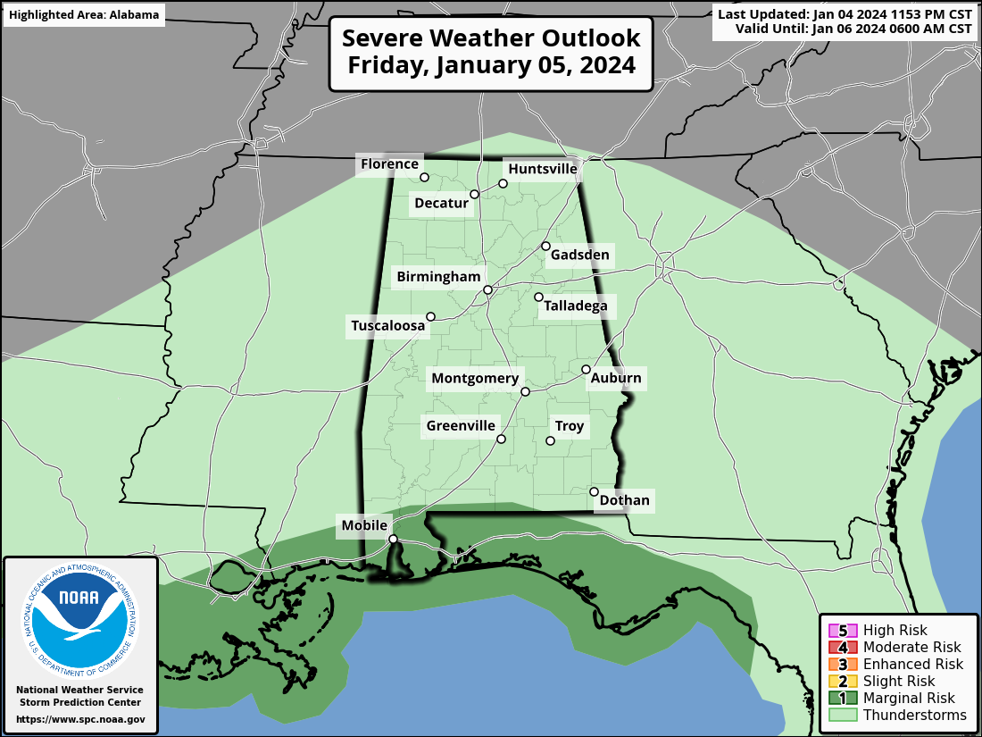
For most of Alabama, the most widespread rain will come in the window from 4:00 this afternoon to 4:00 a.m. tomorrow. Rain amounts of around one inch are likely.
THE ALABAMA WEEKEND: Any lingering showers Saturday will end early, and most of the day will be dry although clouds will linger. Sunday will be rain-free with a mix of sun and clouds; highs over the weekend will be in the 50s.
NEXT WEEK: A dynamic weather system will bring rain and thunderstorms back to Alabama Monday night and Tuesday. SPC has defined a risk of severe thunderstorms for the southern third of Alabama for Monday night and early Tuesday morning.
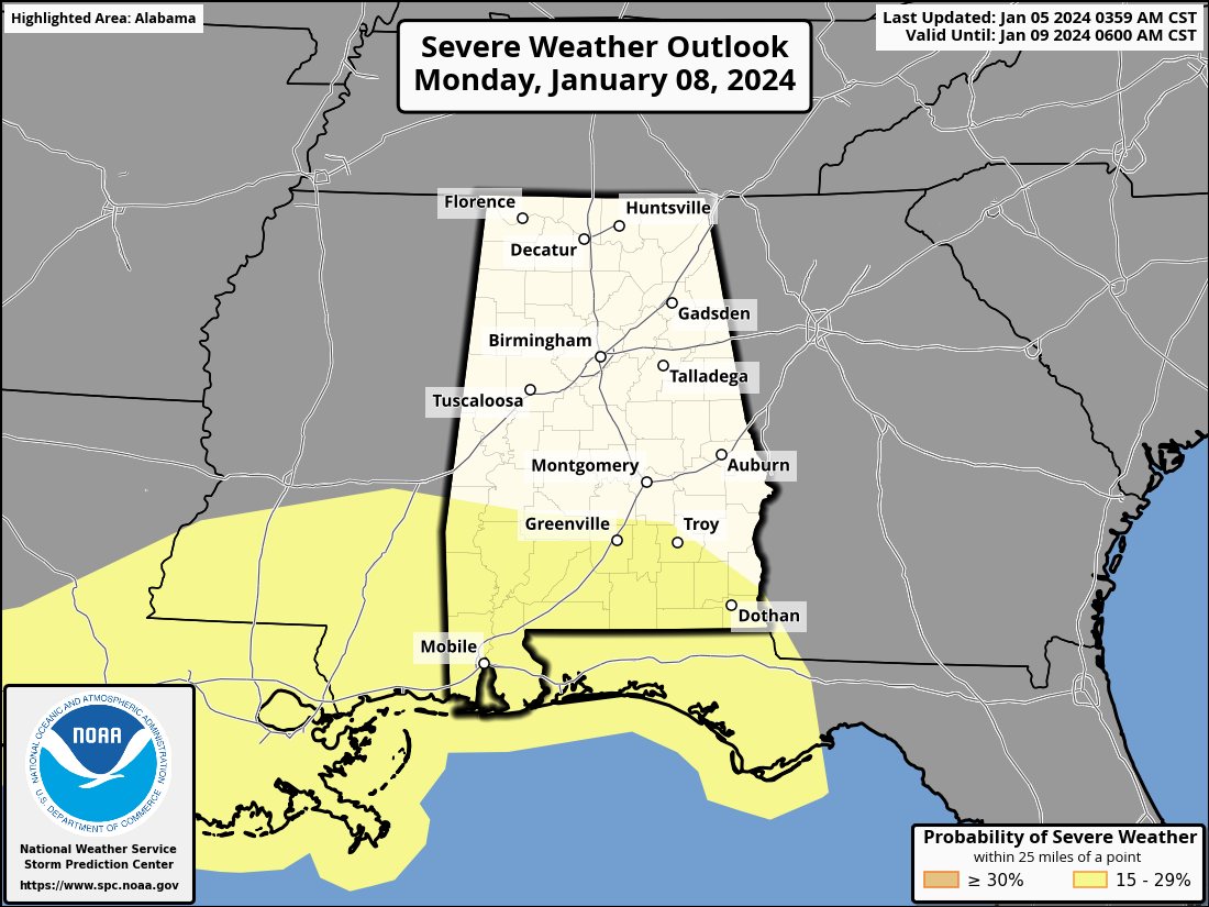
Thunderstorms over South Alabama Monday night will be capable of producing strong winds, and an isolated tornado or two is possible as well. Rain will be heavy at times statewide Monday night into Tuesday, and amounts of 1-2 inches are likely. Gradient winds (not related to thunderstorms) will be strong as well, with gusts to 40 mph likely in spots.
The weather will be dry Wednesday and Thursday, and yet another rain producing system arrives on Friday. Still no sign of any bitterly cold air, or high impact winter weather events for Alabama for the next 7-10 days. See the video briefing for maps, graphics, and more details.
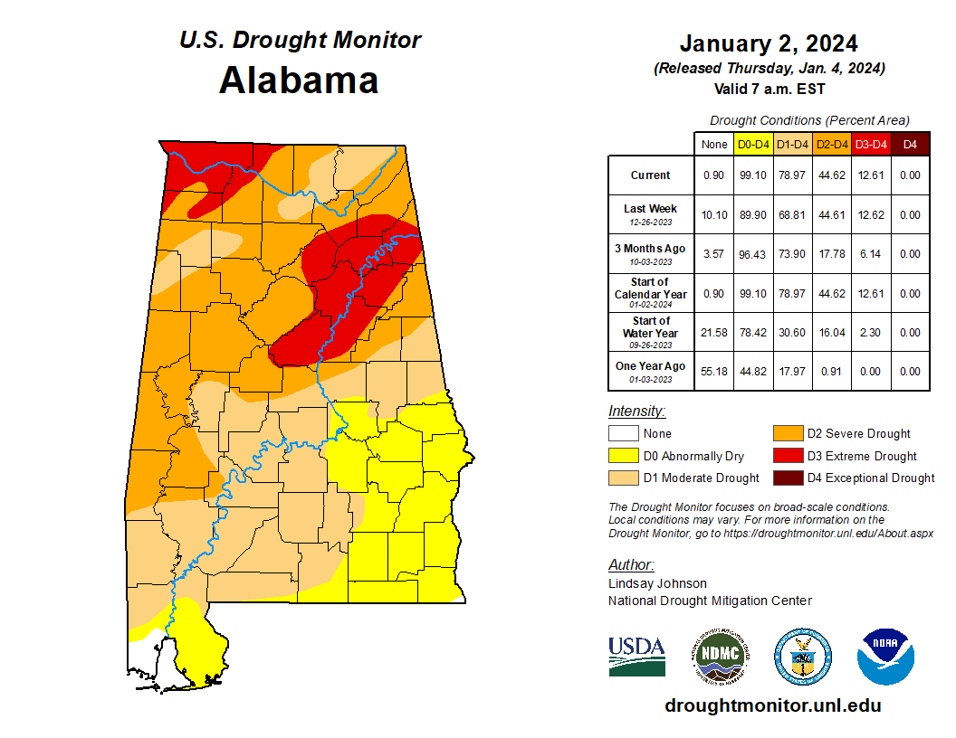
DROUGHT MONITOR: The new drought monitor was released yesterday, showing 79 percent of Alabama in drought conditions. A D3 “extreme drought” remains over parts of North Alabama.
ON THIS DATE IN 1912: Numerous record high temperatures were broken across central and northeast South Dakota and west-central Minnesota throughout the week. Some of the records were broken by as much as 12 to 17 degrees and held 80 to 90 years. Aberdeen surpassed their record high for January by 3 degrees with 63 degrees on Thursday, January 5th.
ON THIS DATE IN 1962: Two tornadoes, about 100 yards apart and each making paths about 100 yards wide, followed parallel paths from southeast to northwest through the edge of the Crestview, Florida’s residential area. These tornadoes killed one and injured 30 others.
Look for the next video briefing here by 3:00 this afternoon… enjoy the day!
Category: Alabama's Weather, ALL POSTS, Weather Xtreme Videos
About the Author (Author Profile)
James Spann is one of the most recognized and trusted television meteorologists in the industry. He holds the AMS CCM designation and television seals from the AMS and NWA. He is a past winner of the Broadcast Meteorologist of the Year from both professional organizations.Subscribe
If you enjoyed this article, subscribe to receive more just like it.


