Alabama Weather Update at 8 a.m.
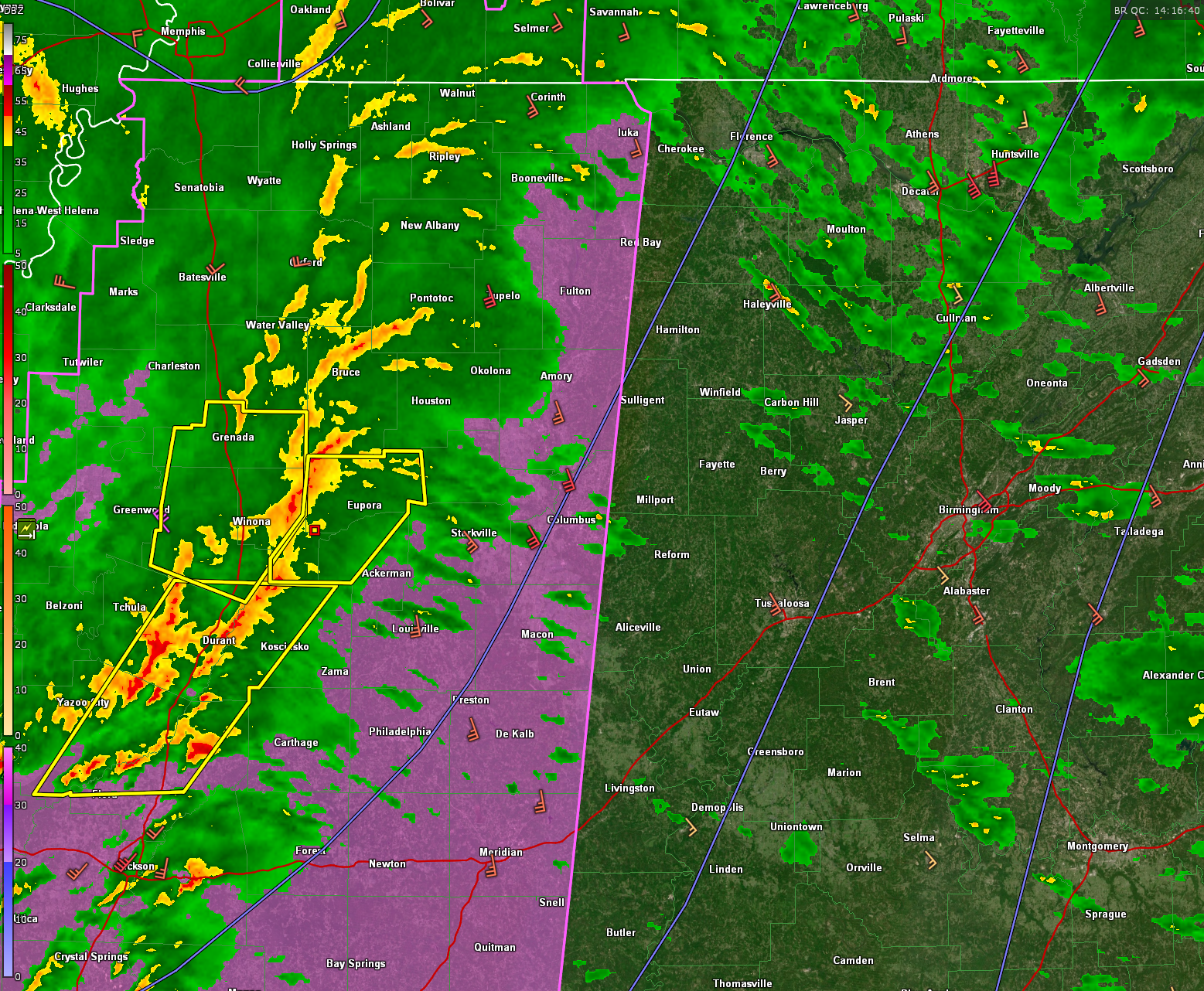
We are tracking a line of strong thunderstorms that are marching eastward across Mississippi at this hour. The main line extends from west of Corinth in North Mississippi to just east of Oxford, to near Winona and Canton on down I-55 to McComb. The line is moving east at about 30 mph.
The strongest storms are in the middle of the line from about Grenada to north of Jackson. There are a few severe thunderstorm warnings in effect at this time. and there has been a couple of tornado warnings.
Multiple trees and power lines were reported down near Indianaola in Sunflower County in the Delta. Winds just gusted to 50 mph at Greenwood in North Central Mississippi.
The Strom Relative Helicity is off the charts at over 500 m2/s2 and bulk shear is as well. Bulk shear values are approaching 70 knots.
CAPE decreases as you move north. It is around 1,250 joules over southern Mississippi, around 1,000 joules around Hazelhurst, around 900 joules near Jackson, and around 2-300 up around Durant.
The mass of storms north of Jackson is of primary concern now, with lots of spinning storms embedded in that mass. The storms to the south are more discrete, but if they get going they have access to higher instability and may present an issue with tornadoes as well.
Low pressure near the Tennessee/Arkansas border may help intensify the storms as we go through the morning, providing backing of the surface winds at the surface, which can help spin up tornadoes.
A tornado watch is in effect for much of Mississippi now. The SPC just issued a mesoscale discussion that mentions the necessity of a downstream tornado watch into Northwest Alabama shortly.
Based on the current eastward motion oof 30 mph, the storms will reach Lamar County between 9:30 and 10 a.m. They will reach Lamar County around 10 a.m., and Sumter County before 11 a.m. They should be to Tuscaloosa by noon and Birmingham around 12:15-12:30 p.m.
Across Alabama now, showers are increasing in coverage across much of the state, moving quickly to the northeast. Not much lightning yet: a little pocket north of Montgomery, and more over Northwest Alabama. Of course, there is much more back across Mississippi.
Gradient winds are strong across the state at this hour and increasing. Winds this hour are gusting to 43 mph at Huntsville, 32 mph at Tuscaloosa, 39 at Birmingham, 21 at Selma and 10 at Anniston. Wind advisories are in effect for every county n the state for winds gusting to 50 mph that will bring down trees, limbs, and power lines, causing scattered power outages.
WE will have frequent updates.
Category: Alabama's Weather, ALL POSTS, Severe Weather
About the Author (Author Profile)
Bill Murray is the President of The Weather Factory. He is the site's official weather historian and a weekend forecaster. He also anchors the site's severe weather coverage. Bill Murray is the proud holder of National Weather Association Digital Seal #0001 @wxhistorianSubscribe
If you enjoyed this article, subscribe to receive more just like it.


