Severe Storms Possible Today; Snow Possible Early Next Week
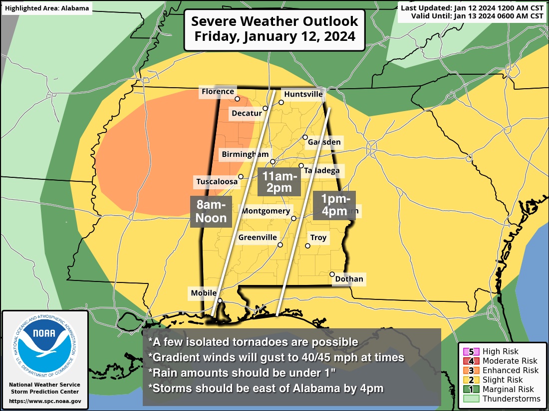
ACTIVE DAY AHEAD: A dynamic weather system will bring windy and wet weather to Alabama today. SPC maintains an “enhanced risk” (level 3/5) of severe thunderstorms for parts of Northwest and West Alabama… the rest of the state is in a “slight risk” (level 2/5).
The main limiting factor in today’s severe weather potential is the lack of surface based instability, but wind fields with the incoming system are impressive. Here are the key messages…
*The window opens up for severe storms in far West Alabama around 8:00 a.m…. the storms progress quickly eastward, and should be out of the state by 3-4 p.m.
*The main concern today will come from strong/damaging straight line winds with thunderstorms across Alabama. But, an isolated tornado or two is certainly possible, especially south of I-20 where instability values will be higher.
*Gradient winds (not related to thunderstorms) will be strong today. Winds will average 15-30 mph, with gusts to 45 mph possible. This could bring down a few trees, and scattered power outages are very possible (if not likely).
*Rain amounts should be under 1 inch for most places, and flooding is not expected.
As always, be sure you have a reliable way of hearing warnings today if they are needed. NEVER an outdoor warning siren. The baseline is a NOAA Weather Radio, and have emergency alerts enabled on your phone. Have helmets for everyone in your safe place. If you live in a mobile home know the location of the nearest shelter and how to get there quickly. Have transportation arranged.
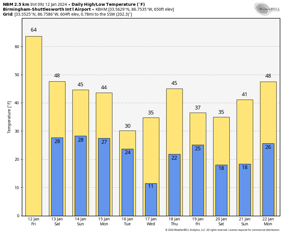
THE WEEKEND: The weather will be colder and dry tomorrow and Sunday. Lows will be in the 25-35 degree range both mornings, with highs in the 40s over North Alabama. South Alabama will see highs in the low to mid 50s both days.
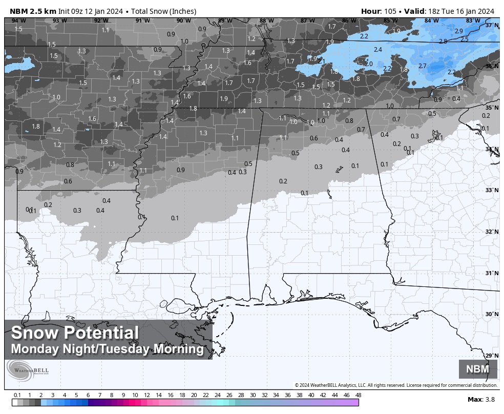
ARCTIC BLAST NEXT WEEK: The coldest air so far this season will blow into the Deep South early next week, and there is a chance of some snow over North Alabama as the cold air arrives late Monday, Monday night, and into Tuesday. For now global models suggest the best chance of accumulating snow will be along and north of I-20, with amounts generally under two inches. We should also mention some freezing rain or sleet will be possible across the central counties of the state.
Some travel impact is possible, but it is still too early to be specific. Once we get today’s system out here, we will be able to focus on the wintry precipitation Monday/Tuesday with a higher confidence forecast.
Temperatures will stay below freezing all day Tuesday, with wind chill values dipping into the single digits. Air temperatures will be in the 7-14 degree range over the northern half of Alabama by daybreak Wednesday, with upper teens all the way down to the Gulf Coast. This will be very similar to what we experienced in December 2022… make plans now for this cold wave.
See the video briefing for maps, graphics, and more details.
ON THIS DATE IN 1888: The Children’s or Schoolhouse Blizzard occurred on this day. The blizzard killed 235 people, many of whom were children on their way home from school, across the Northern Plains.
ON THIS DATE IN 2023: A total of 14 tornadoes touched down in Alabama. An EF-3 that moved through Autauga County was responsible for seven deaths in the Old Kingston community north of Prattville. An EF-2 tornado moved through the heart of Selma.
Look for the next video briefing here by 3:00 this afternoon… enjoy the day!
Category: Alabama's Weather, ALL POSTS, Weather Xtreme Videos
About the Author (Author Profile)
James Spann is one of the most recognized and trusted television meteorologists in the industry. He holds the AMS CCM designation and television seals from the AMS and NWA. He is a past winner of the Broadcast Meteorologist of the Year from both professional organizations.Subscribe
If you enjoyed this article, subscribe to receive more just like it.


