Midday Nowcast: The Deep Freeze
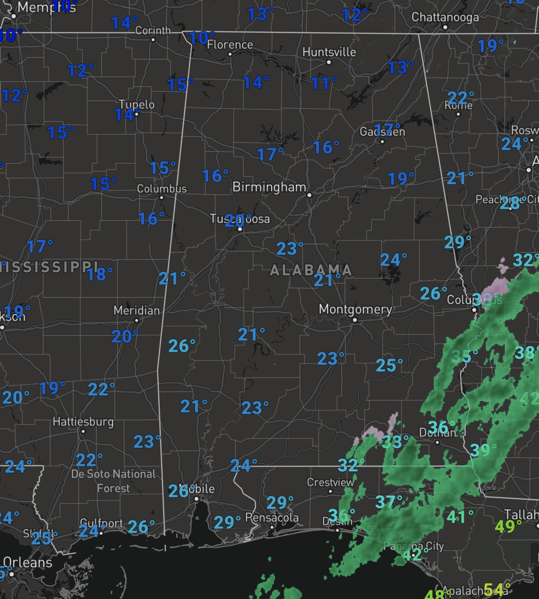
The precipitation has ended across most of the state, but temperatures are in the teens and 20s across Alabama and will not change much the rest of today. Roads remain icy and dangerous over much of North, Central, and West Alabama. With temperatures remaining below freezing today over the northern half of the state, road conditions won’t improve much until tomorrow when we go above freezing by late morning. Wind chills are in the single digits and teens across North/Central Alabama today.
Tonight, will be very cold, with lows in the 5°-15° range over the northern 2/3 of Alabama. Upper teens are possible all the way down to the Gulf Coast. Wind chills will be below zero for many spots. These values are dangerously cold, stay warm and stay safe as best you can. Prolonged sub-freezing temperatures may cause pipes to burst. Bitterly cold temperatures and wind chills can result in hypothermia or frostbite quickly. These conditions are life-threatening to those with prolonged exposure or without access to warmth.
REST OF THIS WEEK: Tomorrow will be sunny, with highs in the mid to upper 30s. Temperatures rise into the upper 40s Thursday, but clouds will increase through the day, and some light rain is likely late Thursday afternoon and Thursday night. For now, it looks like any freezing or frozen precipitation will be just to the north of Alabama. We could see a few flurries on the back side of the system late Thursday night after midnight, but for now no major impact is expected.
ANOTHER ARCTIC BLAST: The next surge of Arctic air invades the Deep South Friday. The sky will clear with highs in the 30s along with a brisk north wind, making those wind chills likely in the teens. Lows will be in the teens for most of the state Saturday and Sunday mornings. North Alabama will stay below freezing all day Saturday. Sunday will begin a slow warming trend as highs climb into 40s. Both days this weekend will feature sunshine in full supply.
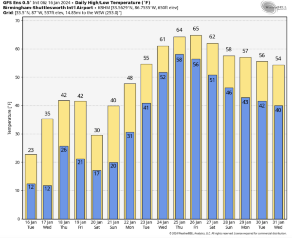
PATTERN FLIP: A drastic change in the weather for Alabama next week, as warmer weather returns. We go from the frigid Arctic air, to actually above average temperatures for much of next week. Afternoon highs will return the 60s by mid-week. The pattern will be active and rain chances will be in the forecast much of next week.
BEACH FORECAST CENTER: Get the latest weather and rip current forecasts for the beaches from Fort Morgan to Panama City on our Beach Forecast Center page. There, you can select the forecast of the region that you are interested in visiting.
WORLD TEMPERATURE EXTREMES: Over the last 24 hours, the highest observation outside the U.S. was 110.8F at Paraburdoo Aero, Australia. The lowest observation was -64.8F at Agayakan, Russia.
CONTIGUOUS TEMPERATURE EXTREMES: Over the last 24 hours, the highest observation was 85F at Sunniland, FL. The lowest observation was -36F at Briggsdale, CO.
Category: Alabama's Weather, ALL POSTS, Winter Weather
About the Author (Author Profile)
Macon, Georgia Television Chief Meteorologist, Birmingham native, and long time Contributor on AlabamaWX. Stormchaser. I did not choose Weather, it chose Me. College Football Fanatic. @Ryan_StinnetSubscribe
If you enjoyed this article, subscribe to receive more just like it.


