

Temps Above Freezing For Most Later Today; More Arctic Air Friday
FRIGID: Here are some temperatures across Alabama just before sunrise…
Haleyville 2
Muscle Shoals 4
Gadsden 6
Tuckers Chapel 6
Heflin 8
Morris 8
Bessemer 8
Huntsville 9
Chelsea 9
Trussville 9
Ashville 9
Leeds 9
Hueytown 9
Birmingham 11
Anniston 11
Auburn 11
Tuscaloosa 13
Greenville 14
Montgomery 16
Dothan 20
Mobile 20
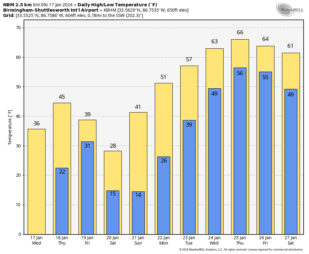
With sunshine in full supply, most of Alabama will climb above freezing this afternoon, but parts of the Tennessee Valley of North Alabama could hold at or below 32 all day. Tonight will be mostly clear with a low in the 15-25 degree range.
REST OF THE WEEK: Clouds move in tomorrow as temperatures rise into the 40s by afternoon. Light rain is likely tomorrow afternoon into tomorrow night; any “winter mischief” will stay in Tennessee this time. Then, another surge of Arctic air begins to arrive Friday as highs drop into the 30s and 40s.
THE ALABAMA WEEKEND: Lows will be in the teens again both Saturday and Sunday morning. Colder spots could see single digit lows over North Alabama early Saturday. The weekend will be dry with a sunny sky both days; the northern half of Alabama will stay below freezing all day Saturday, with mid 30s for South Alabama. Then, highs return to the 40s Sunday.
NEXT WEEK: A pattern flip means much warmer weather for the Deep South and the contiguous U.S. We will be dry Monday, but the rest of the week looks fairly wet with periods of rain daily Tuesday through Friday. Highs will be generally in the 50s Monday and Tuesday, followed by 60s Wednesday through Friday.
And, it looks like temperatures will remain above average around here through the end of January. See the video briefing for maps, graphics, and more details.
ON THIS DATE IN 1982: Strong chinook winds caused severe wind damage in Boulder, Colorado. A wind gust of 118 mph was recorded on the roof of the Environmental Research Laboratories (ERL), and a wind gust of 137 mph was measured atop the roof of the NCAR building
ON THIS DATE IN 1999: An F4 tornado tracked across southern Jacksonville, Tennessee, damaging more than 200 homes and 55 buses. The storm killed six people and injured 106.
ON THIS DATE IN 2013: One to three inches fell across the northern half of Alabama, with locally higher amounts of 4 to 5 inches also reported. Thundersnow, a very rare occurrance here in the South, was observed with the heaviest snow band as it moved across Tuscaloosa, Walker, Jefferson, and St Clair Counties.
Look for the next video briefing here by 3:00 this afternoon… enjoy the day!
Category: Alabama's Weather, ALL POSTS, Weather Xtreme Videos
About the Author (Author Profile)
James Spann is one of the most recognized and trusted television meteorologists in the industry. He holds the AMS CCM designation and television seals from the AMS and NWA. He is a past winner of the Broadcast Meteorologist of the Year from both professional organizations.Subscribe
If you enjoyed this article, subscribe to receive more just like it.


