Alabama Update at 2:30 p.m.
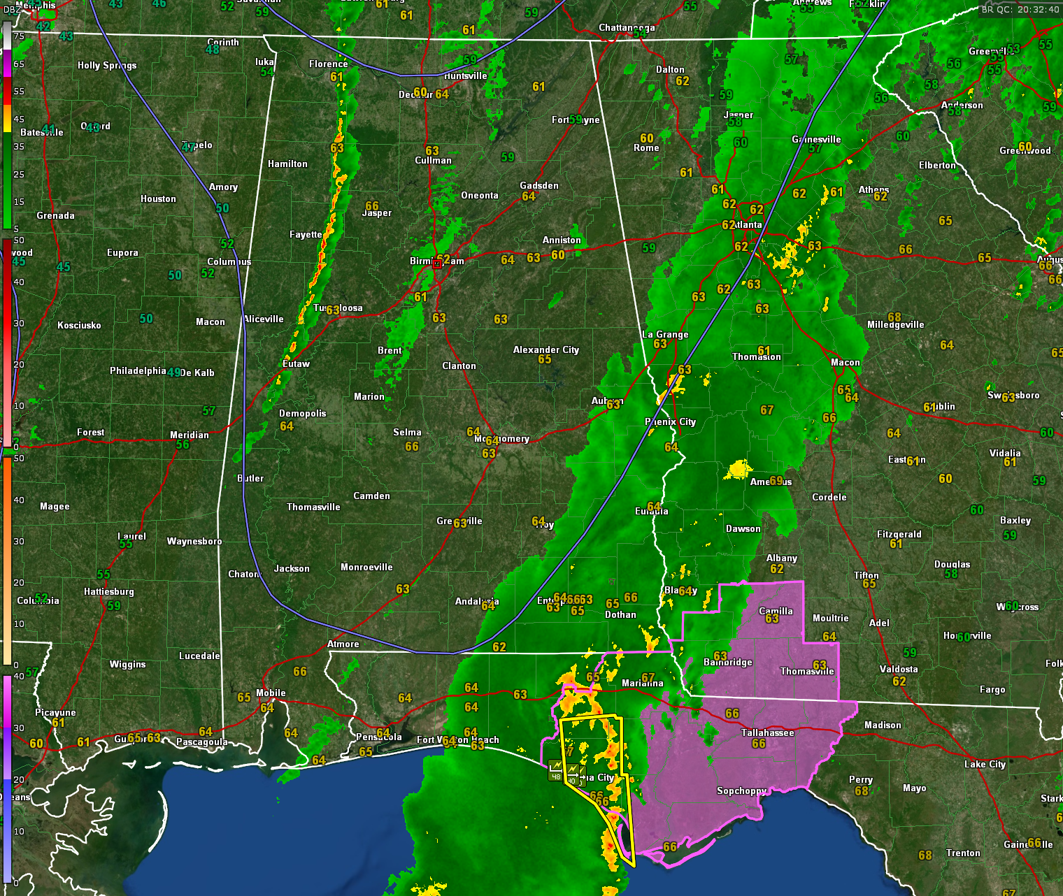
A line of convective heavy showers is moving across western Alabama ahead of a strong cold front. There are a few lightning strokes with this line, but very few.
It extends from Florence and Tuscumbia in Lauderdale and Colbert Counties to near Russellville in Franklin County to near Brilliant in Marion County to east of Fayette in Fayette County on into eastern Pickens County east of Gordo to just west of Union to near Gainesville, Epes, and Livingston in Sumter County.
This line of heavy showers is moving east at 40-45 mph. It will reach Tuscaloosa before 3 p.m. and Birmingham between 330 and 4 p.m.
They should continue to slowly intensify but shouldn’t increase to severe limits in the next hour. They could reach severe limits in some cases over Eastern Alabama east of I-65.
There is still a small chance of a damaging wind gust over eastern Alabama today from Madison to Locust Fork to Westover to Prattville to Andalusia.
Ahead of that, some light rain is moving through the Birmingham Metro now from southeastern Cullman County into western Blount, Central Jefferson and Bibb Counties.
The first round of storms that moved through Alabama this morning is now over the eastern Florida Panhandle. A severe thunderstorm warning is in effect for Washington, Bay and western Gulf counties.
A mesoscale convective vortex is located over Washington County with a line of strong storms extending back to the south from Wausau and Youngstown down to Tyndall AFB. These storms are approaching Mexico Beach and the St. Joseph Peninsula.
Getting several high wind reports now from Bay County including 48 mph at PC Beach and 40 mph at the PC Sports Complex.
A tornado watch is in effect until 6 p.m. CST for counties in southwestern Georgia ab the Florida Panhandle. There is a possibility of damaging wind gusts and a couple of brief tornadoes.
Category: Alabama's Weather, ALL POSTS, Severe Weather
About the Author (Author Profile)
Bill Murray is the President of The Weather Factory. He is the site's official weather historian and a weekend forecaster. He also anchors the site's severe weather coverage. Bill Murray is the proud holder of National Weather Association Digital Seal #0001 @wxhistorianSubscribe
If you enjoyed this article, subscribe to receive more just like it.


