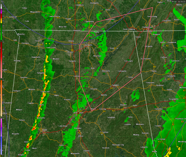
Mesoscale Discussion for Northeastern Alabama…Watch Not Anticipated But Tornado Possibility is There
Mesoscale Discussion 0094
NWS Storm Prediction Center Norman OK
0244 PM CST Sat Jan 27 2024
Areas affected…parts of northeastern Alabama into southeastern
Tennessee and adjacent northwestern Georgian
Concerning…Severe potential…Watch unlikely
Valid 272044Z – 272315Z
Probability of Watch Issuance…20 percent
SUMMARY…Showers and thunderstorms overspreading the region late
this afternoon may become capable of posing at least some risk for
producing a tornado or two.
DISCUSSION…Persistent convective development, spreading across the
southern Georgia/Alabama state border vicinity, western Florida
Panhandle and north central into northeastern Gulf of Mexico, has
impeded low-level moisture return to the warm sector of a developing
surface cyclone, farther inland across the central Gulf States into
Tennessee Valley. However, Rapid Refresh forecast soundings suggest
that weak boundary-layer destabilization is ongoing, ahead of the
eastward advancing cold front which trails the modest, but
deepening, surface low center as it migrates north-northeastward
through middle Tennessee. This is being aided by insolation beneath
the low/mid-level dry slot, and the onset of mid-level cooling,
which are contributing to sufficient conditional and convective
instability to support a line of strengthening thunderstorm
development near/just ahead of the front.
While this convection is generally low-topped in nature, strong
shear through the convective layer may contribute to further
organization and the evolution of embedded supercell structures.
The evolution of more discrete cells just ahead of this activity may
not be out of the question, as it advances toward the Cumberland
Plateau/southern Appalachians vicinity through early evening.
Across parts of northeastern Alabama into adjacent portions of
southeastern Tennessee and northwestern Georgia, Rapid Refresh
forecast soundings have indicated that weak boundary-layer
destabilization through 21-00Z may coincide with low-level
hodographs characterized by sizable clockwise curvature, before
trending linear near the approaching cold front. While the overall
environment, at best, may be marginal, there appears some window of
opportunity for convection to pose a risk for producing a tornado or
two through early evening.
..Kerr/Hart.. 01/27/2024
Category: Alabama's Weather, ALL POSTS, Severe Weather


