Dry Through Thursday; Showers Return Friday Afternoon
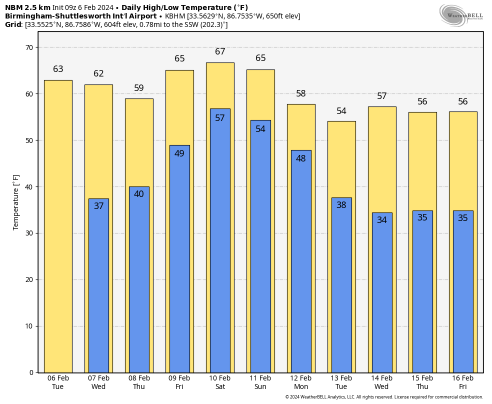
CHILLY NIGHTS, PLEASANT AFTERNOONS: We are forecasting sunshine in fully supply today with a nice warm-up… expect a high in the 60s statewide. Dry weather continues tomorrow and Thursday with chilly nights and pleasant afternoons. Then, on Friday, clouds return along with a chance of showers by afternoon with the approach of a cold front. Rain amounts won’t be too heavy Friday, and the high will be in the 64-72 degree range.
THE ALABAMA WEEKEND: The front will become stationary, meaning a wet weekend for the Deep South. We expect periods of rain Saturday and Sunday along with a thunderstorm or two. The weather will remain fairly mild for February with high in the 60s… South Alabama could see low 70s both days. Rain could very well linger into Monday morning; rain amounts of 1-2 inches are likely Friday through Monday.
REST OF NEXT WEEK: The weather looks dry Tuesday through Friday with seasonal temperatures. Highs in the 50s, lows in the 30s… See the video briefing for maps, graphics, and more details.
RAIN UPDATE: Here are rain totals since January 1 and the departure from average for the major reporting stations in Alabama…
Montgomery 11.19″ (+5.72″)
Tuscaloosa 10.24″ (+5.81″)
Muscle Shoals 10.01″ (+4.51″)
Mobile 9.14″ (2.69″)
Anniston 8.93″ (+3.25″)
Dothan 7.76″ (+2.21″)
Birmingham 7.71″ (+1.85″)
Huntsville 7.55″ (+1.72″)
ON THIS DATE IN 1978: A massive nor’easter buried the northeastern U.S. Storm totals’ cities, including 18 inches in New York City, 16 inches at Philadelphia, and 14 inches in Baltimore. The Boston MA area received 25 to 30 inches in “The Great New England Blizzard.” The mayor outlawed travel in the city for an entire week.
ON THIS DATE IN 2008: The “Super Tuesday” tornado outbreak was winding down. The event began on Super Tuesday, while 24 states in the United States were holding primary elections and caucuses to select the presidential candidates for the upcoming presidential election. The outbreak generated 87 tornadoes over 15 hours from the afternoon of February 5 until the early morning of February 6. The storm system produced several destructive tornadoes in heavily populated areas, most notably in the Memphis metropolitan area, in Jackson, Tennessee, and the northeastern end of the Nashville metropolitan area.
Seven tornadoes touched down in Alabama, including a pre-dawn EF4 that moved through parts of Lawrence and Morgan counties. The Aldridge Grove, Fairfield, Five Points, Midway, and Caddo communities were hardest hit. Another EF4 moved through Jackson County; the most significant damage occurred at the corner of County Road 60 and 177, between the Rosalie and Pisgah communities. One person was killed in that tornado.
Look for the next video briefing here by 3:00 this afternoon… enjoy the day!
Category: Alabama's Weather, ALL POSTS, Weather Xtreme Videos
About the Author (Author Profile)
James Spann is one of the most recognized and trusted television meteorologists in the industry. He holds the AMS CCM designation and television seals from the AMS and NWA. He is a past winner of the Broadcast Meteorologist of the Year from both professional organizations.Subscribe
If you enjoyed this article, subscribe to receive more just like it.


