Much of the Area Dry at Midday; Rain Affecting Portions of North Alabama
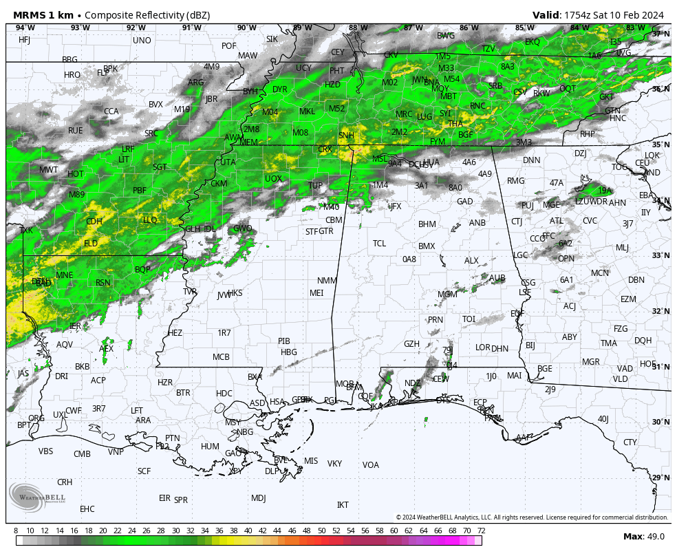
As we have reached the midday hour in North/Central Alabama, we have a line of light to moderate showers over the extreme north and northwestern parts of the area. This activity is very slowly moving to the east and will eventually spread over a good portion of the northern-third of the state by the end of the afternoon. Rain will be likely for locations north of a line from Tuscaloosa to Gardendale to Jacksonville, while chances drop as you move south. The activity will decrease during the evening and overnight, but nearly all the area will have a small chance of showers. Highs will top out in the upper 60s to the mid 70s, with overnight lows only falling into the mid 50s to the lower 60s.
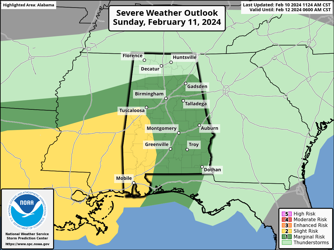
All of this activity is associated with a cold front that will wash out over the central portions of the area on Sunday. Rain and thunderstorms will be likely across the area, and we have the potential for strong to severe storms. A Slight risk is up for the west and southwestern parts of Central Alabama, mainly from Moundville to Orrville to Flomation in South Alabama. The rest of Central Alabama and portions of North Alabama south of a line from Detroit to Haleyville to Albertville to Cedar Bluff are under a Marginal Risk on Sunday. We do have the threat of tornadoes and damaging thunderstorm wind gusts up to 60 mph during a window from Sunday evening through a good portion of Monday morning. Please stay weather aware during that window, and have a way to be awakened if your location goes under a warning. Highs in the lower 60s to the mid 70s.
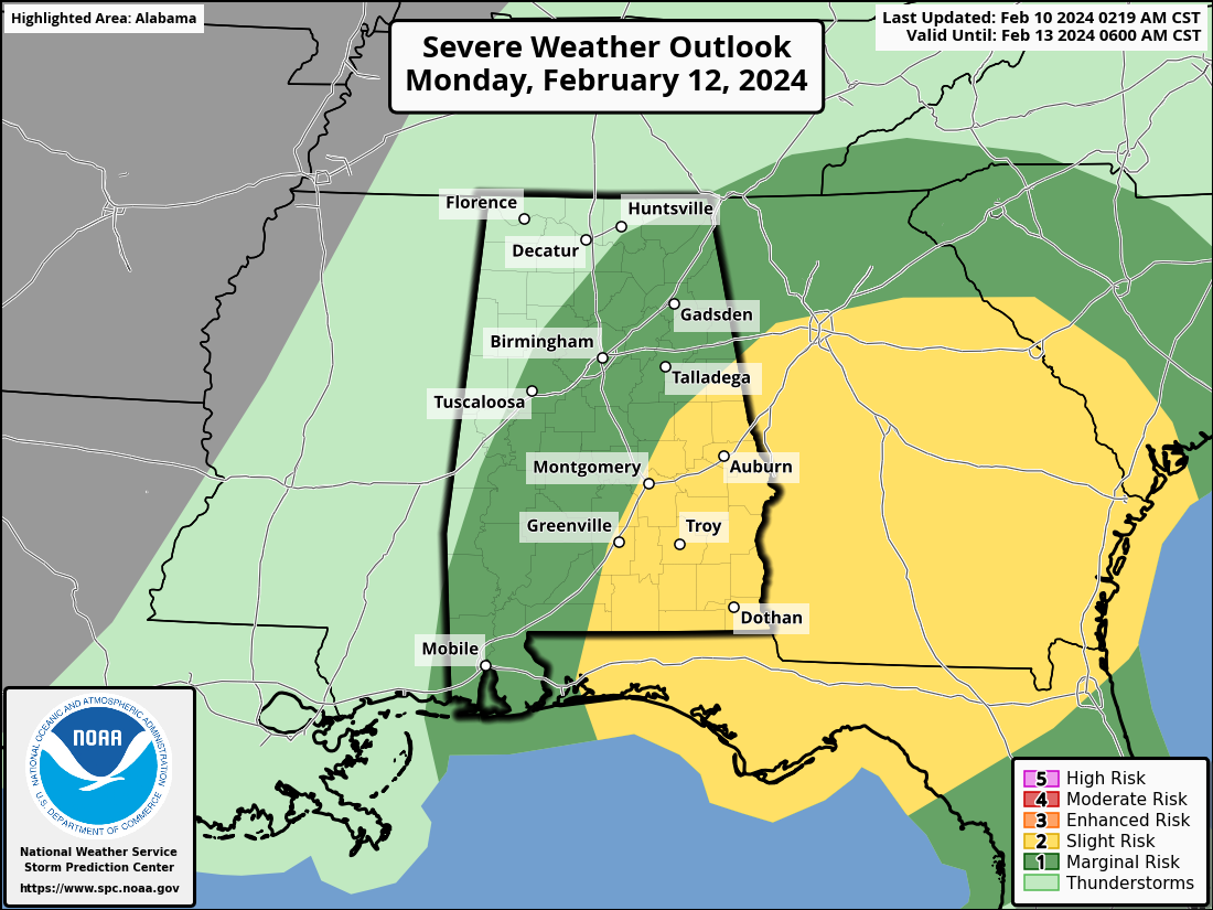
The front will be moving back northward as a warm front ahead of the main low associated with another cold front that will push through the area on Monday. Rain and storms will be likely once again, and once again, there will be a risk of strong to severe storms. This time, the Slight Risk will be on the eastern side of the state, with locations east of a line from Wedowee to Montgomery to Fort Deposit. Much of the rest of Central Alabama and a good portion of North Alabama is under a Marginal risk, including locations east of a line from Boligee to West Point to Bridgeport. Tornadoes and damaging wind gusts will be the main threats. The severe threat should be over by the start of the afternoon, but some rain and thunder may continue into the evening hours. We should be dry by midnight. Highs in the lower 60s to the lower 70s.
The rest of the work week kill be dry with OK temperatures. We are looking at plenty of sunshine for Tuesday and Wednesday, with a slow increase in clods starting on Thursday. By Friday, clouds will make the skies partly to mostly cloudy, and rain will begin to move into the area during the evening hours. Highs will be in the 50s and 60s through those upcoming four days.
Category: Alabama's Weather, ALL POSTS, Severe Weather
About the Author (Author Profile)
Scott Martin is an operational meteorologist, professional graphic artist, musician, husband, and father. Not only is Scott a member of the National Weather Association, but he is also the Central Alabama Chapter of the NWA president. Scott is also the co-founder of Racecast Weather, which provides forecasts for many racing series across the USA. He also supplies forecasts for the BassMaster Elite Series events including the BassMaster Classic.Subscribe
If you enjoyed this article, subscribe to receive more just like it.


