Midday Nowcast: Increasing Clouds, Some Rain and Storms Later Today
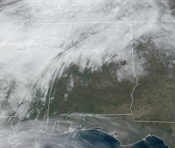
We are seeing widespread 70s today, but clouds are increasing ahead a cold front which will bring rain and a few storms to Alabama this afternoon and evening. Rain amounts will be under 1/2 inch and though some storms are expected the threat of severe storms is very low.
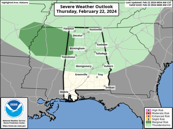
We do note, the SPC has introduced a “marginal risk” (level 1 of 5) across North Mississippi and this does extend into far West Alabama. A few storms in these areas could produce some gusty winds and hail.
THROUGH THE WEEKEND: Expect a clearing sky tomorrow with highs in the 60s. Then for the weekend, expect the nicest weekend of weather so far in 2024 for Alabama. Expect mostly sunny, pleasant days and fair nights both Saturday and Sunday. Highs Saturday will be closer to 60°, but temperatures will surge into the upper 60s and low 70s Sunday as the warming trend begins.
NEXT WEEK: The week starts off dry with splendid spring-like temperatures; highs will be in the mid and upper 70s. However, with spring-like warmth comes spring-like storms by the middle of the week as a strong cold front and dynamic storm system will bring the threat of severe weather to much of the South. The SPC has defined a risk of severe thunderstorms for about the northern 2/3 of the state Wednesday.
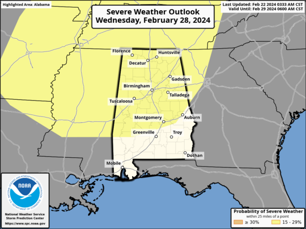
For now, it looks like a line of storms will pass through Wednesday night. The main upper support and strong wind fields will be north and west of Alabama, and this is where the best chance of severe storms will likely be and this could be quite the severe weather event for areas across the Mid-South. This threat is still 6-7 days out and a lot could easily change; just know we are watching it and there is nothing to worry about now. Enjoy the great weekend of weather ahead, and we will worry about next week’s system, next week. For the end of next week, cooler air will move back into the state, and highs will settle back down into the 60s, which are seasonable for this time of year.
BEACH FORECAST CENTER: Get the latest weather and rip current forecasts for the beaches from Fort Morgan to Panama City on our Beach Forecast Center page. There, you can select the forecast of the region that you are interested in visiting.
WORLD TEMPERATURE EXTREMES: Over the last 24 hours, the highest observation outside the U.S. was 115.3F at Paraburdoo Aero, Australia. The lowest observation was -77.3F at Vostok, Antarctica.
CONTIGUOUS TEMPERATURE EXTREMES: Over the last 24 hours, the highest observation was 99F at Rio Grande Village, TX. The lowest observation was 1F at Mackay, ID.
Category: Alabama's Weather, ALL POSTS
About the Author (Author Profile)
Macon, Georgia Television Chief Meteorologist, Birmingham native, and long time Contributor on AlabamaWX. Stormchaser. I did not choose Weather, it chose Me. College Football Fanatic. @Ryan_StinnetSubscribe
If you enjoyed this article, subscribe to receive more just like it.


