Midday Nowcast: Wet is the Word
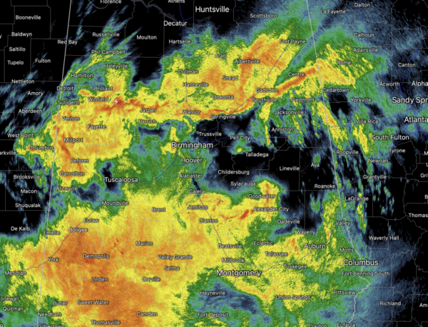
We are seeing a widespread soaking rain with embedded rumbles of thunder across Alabama today. Today is one of those days we can day there is a 100% of rain, with every part of the state seeing the wet stuff. The rainfall is heavy at times, and some areas of isolated flooding are possible. It is a cold rain with many locations in the 40s, and temperatures are going to struggle to climb into the 50s this afternoon. The mass of rain will shift eastward later this afternoon, but this evening and overnight, scattered areas of rain will remain in the forecast with lows in the upper 40s.
ACROSS THE USA: A powerful winter storm is underway across the west bringing heavy higher elevation mountain snow, dangerous blizzard for the Sierra Nevada Mountains, damaging winds, hazardous sea conditions and cold temperatures to much of the West through this weekend. Snow totals from this system in the mountains will be in the 5-10 feet range, and yes, you read that right, feet. Meanwhile, critical fire weather concerns increase this weekend for portions of the central and southern High Plains.
WARMER WEEKEND WEATHER: The sky will be remain generally cloudy, with some scattered showers possible both days. Nothing too heavy or widespread, and it won’t be a weekend washout by any means as rain chances will be in the 20-30% range; just be prepared for some rain at anytime. It will warmer with highs mostly in the upper 60s to low 70s tomorrow, followed by low and mid 70s Sunday.
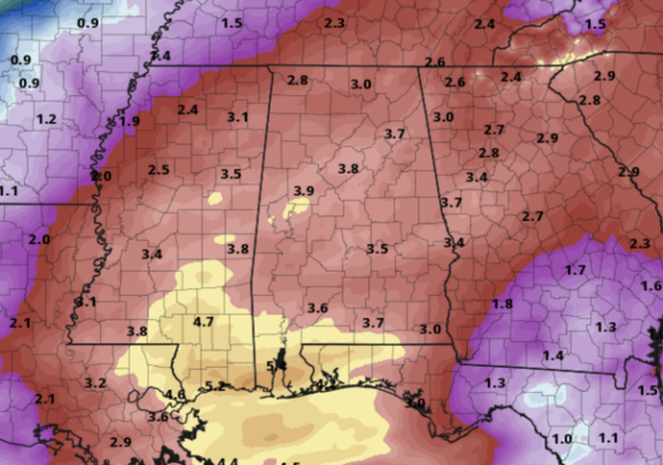
NEXT WEEK: Clouds, rain, and mild temperatures are the story next week with some scattered rain remaining possible Monday. Showers and storms are more likely Tuesday through Friday and some stronger storms possible towards the end of the week, but this remain too far out to know any specifics as model inconsistencies remain. Even though it will be cloudy and dreary most of the week, at least it will be very mild with highs mostly in the 70s. Rainfall totals over the next seven days will be in the 3-4 inch range for much of Alabama, with amounts in excess of five inches are expected near the Gulf Coast.
BEACH FORECAST CENTER: Get the latest weather and rip current forecasts for the beaches from Fort Morgan to Panama City on our Beach Forecast Center page. There, you can select the forecast of the region that you are interested in visiting.
WORLD TEMPERATURE EXTREMES: Over the last 24 hours, the highest observation outside the U.S. was 111.2F at Tarcoola, Australia. The lowest observation was -80.3F at Concordia, Antarctica.
CONTIGUOUS TEMPERATURE EXTREMES: Over the last 24 hours, the highest observation was 86F at Miles City, FL. The lowest observation was -17F at Mount Washington, NH.
Category: Alabama's Weather, ALL POSTS
About the Author (Author Profile)
Macon, Georgia Television Chief Meteorologist, Birmingham native, and long time Contributor on AlabamaWX. Stormchaser. I did not choose Weather, it chose Me. College Football Fanatic. @Ryan_StinnetSubscribe
If you enjoyed this article, subscribe to receive more just like it.


