Midday Nowcast: Wet Tuesday Forecast
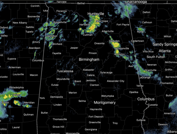
Periods of rain and storms continue across Alabama today and tonight. At the writing of this forecast, much of Central Alabama is seeing a break in the rain, but more rain and storms will develop through the afternoon and evening hours.
The rain could be heavy with rainfall totals near one inch; we are not expecting any severe thunderstorms, but we do expect some lightning and thunder at times. Temperatures today are ranging from the upper 60s to lower 70s.
TOMORROW/THURSDAY: A few isolated showers will remain possible these two days, but nothing widespread or heavy. We will continue to see a mix of sun and clouds and very mild temperatures with afternoon highs in the mid 70s.
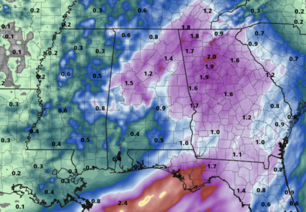
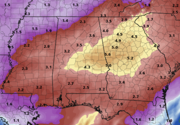
WET AND STORMY END OF WEEK: A dynamic weather system will bring rain and thunderstorms back to Alabama Friday and into at least part of the day Saturday. The SPC maintains a risk of severe thunderstorms for the southern third of Alabama Friday and Friday night as some strong to severe storms are possible down that way. However, the main concern with the end of week system will be the potential for flooding. The rainfall will be heavy at times, and flooding is very possible. Rain amounts Friday and into Saturday will be in the 2-4 inch range for much of Alabama, with isolated higher amounts.
DRY WEATHER RETURNS: Finally sunshine and a drier weather will return to Alabama Saturday. Sunday will be a mostly sunny, cooler day with a high in the upper 50s and low 60s. The drier pattern looks to persist into next week with highs in the 60s Monday and Tuesday, followed by 70s over the latter half of the week.
BEACH FORECAST CENTER: Get the latest weather and rip current forecasts for the beaches from Fort Morgan to Panama City on our Beach Forecast Center page. There, you can select the forecast of the region that you are interested in visiting.
WORLD TEMPERATURE EXTREMES: Over the last 24 hours, the highest observation outside the U.S. was 111.6F at Kano, Nigeria. The lowest observation was -77.8F at Amundsen-Scott South Pole Station, Antarctica.
CONTIGUOUS TEMPERATURE EXTREMES: Over the last 24 hours, the highest observation was 88F at Rio Grande Village, Castolon, and Lesley, TX. The lowest observation was -22F at Peter Sinks, UT.
Category: Alabama's Weather, ALL POSTS
About the Author (Author Profile)
Macon, Georgia Television Chief Meteorologist, Birmingham native, and long time Contributor on AlabamaWX. Stormchaser. I did not choose Weather, it chose Me. College Football Fanatic. @Ryan_StinnetSubscribe
If you enjoyed this article, subscribe to receive more just like it.


