An Update on the Alabama Weather Situation at 10:45 a.m.
Here is the current Day One Severe Weather Outlook for Alabama and surrounding areas:
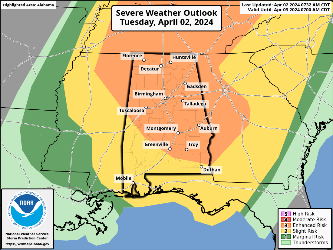
It will be updated in about 45 minutes.
As a potent weather system moves through the region, severe weather is forecast to affect North and Central Alabama today and into tonight.
SETUP
A strengthening surface low is approaching Chicago this morning. The pressure is expected to drop from 992mb to 989 mb by early this afternoon.
Current radar:
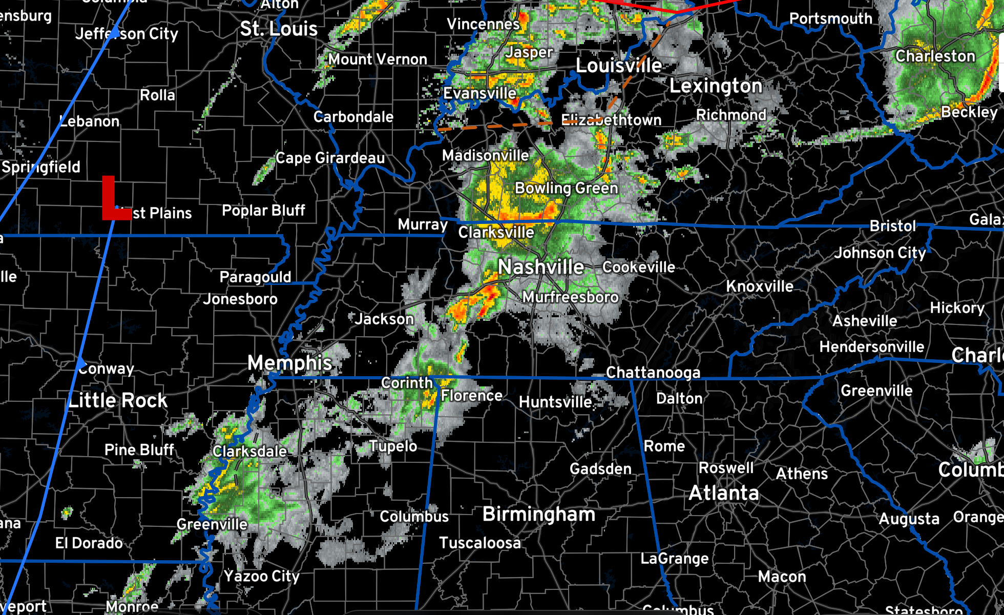
CURRENT SITUATION
…A tornado watch is in effect for southern Kentucky and western Tennessee now until 3 pm and a separate tornado watch for West Virginia, extreme southern Ohio, and northeastern Kentucky until 1 pm EDT.
…Strong thunderstorms associated with a Mesoscale Convective Complex are moving through Middle Tennessee. There are no warnings in Tennessee currently, but there were a few severe thunderstorm warnings in effect as well as a couple of tornado warnings a couple of hours ago. There are severe thunderstorm and tornado warnings in effect for West Virginia.
THREAT FOR ALABAMA
There is a threat of damaging winds, hail and a few tornadoes for areas from Ohio, Indiana and West Virginia, through Kentucky and Tennessee into Alabama, Mississippi, and Georgia.
…For Alabama: Primary concerns include damaging winds of up to 60-70 mph, hail up to the size of ping pong balls, and the possibility of several tornadoes.
…The greatest threat of hail and damaging winds is along and north of I-20.
…The tornado threat covers a large part of Alabama and includes the threat of stronger tornadoes.
SEVERE WEATHER PARAMETERS
…Instability will be running in the 750-1500 joules/kg range ahead of the line of storms, which is sufficient for severe storms.
…Bulk shear values will be running over 60 knots in the 0-6km layer, which is high.
…Storm relative helicity values in the 0-1 km range will increase as the system moves east across the Tennessee Valley. It will be sufficient for tornadoes across the entire Tennessee Valley, but could be worse over Northeast Alabama in places like Centre, Fort Payne, Gadsden, and Ragland.
…The maritime warm front will lift out of the Gulf during the late afternoon and evening, reaching Montgomery around 5 p.m. and Birmingham by 9 p.m. This richer moisture with dewpoints over 65F will briefly coincide with the better helicity after 6-7 p.m. across parts of Central Alabama.
Here is the tornado outlook:
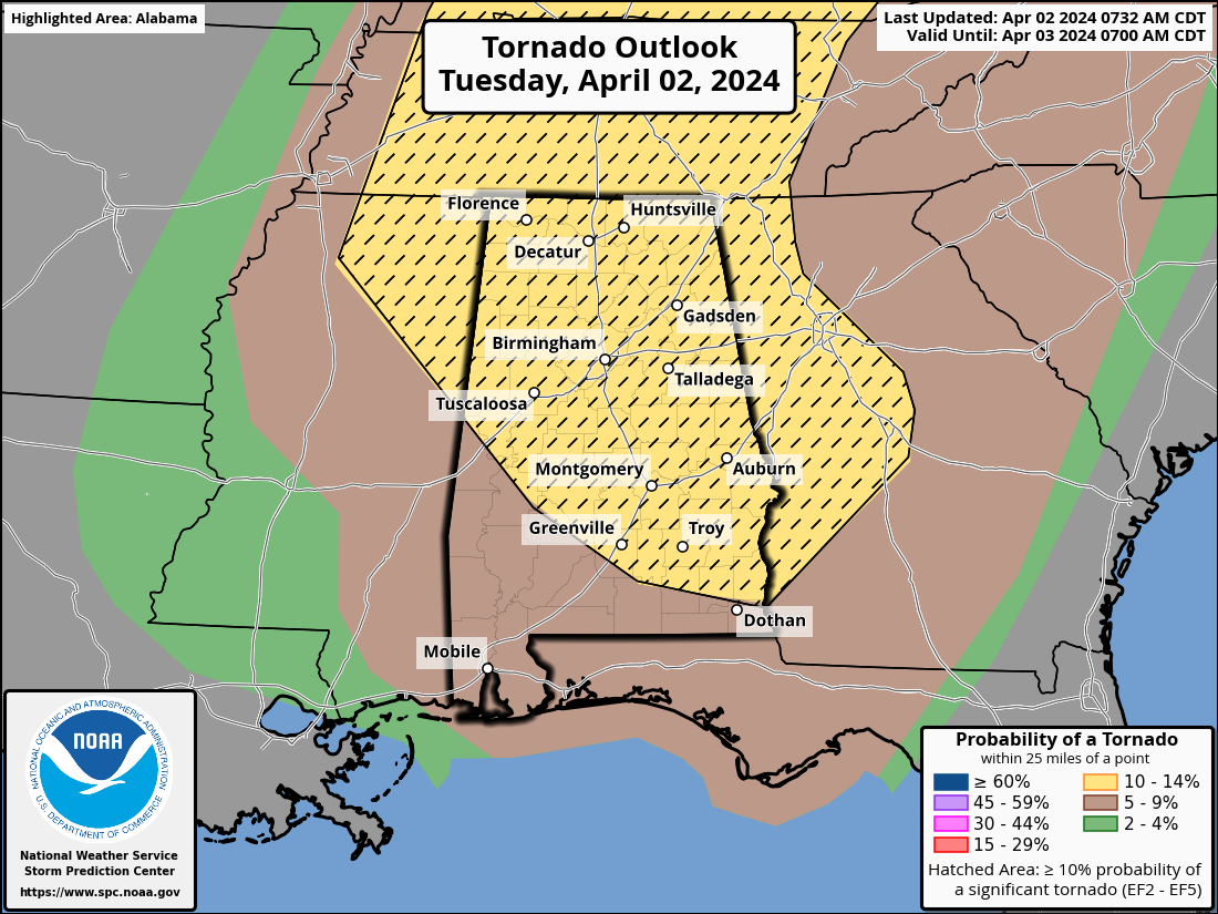
The hatched area indicates a greater than 10% chance of a significant tornado (EF2 or greater) within 25 miles of any point.
TIMING FOR ALABAMA
…The line of strong storms will develop ahead of the cold front and will reach Northwest Alabama around 3 p.m.
…A second line of storms will develop along and south of I-59 between West Alabama and the Birmingham Metro around 7 p.m. These storms could grow rapidly as they spread across Central Alabama through midnight. The storms should weaken after midnight.
…The threat will move into Georgia after 2 a.m.
Following the front, cooler and drier air will lead to a drop in temperatures and gusty conditions across Alabama on Wednesday.
Residents throughout North and Central Alabama are advised to stay vigilant and prepared. Having multiple methods to receive weather warnings is crucial, along with readiness for quick action should severe weather develop.
Category: Alabama's Weather, ALL POSTS, Severe Weather
About the Author (Author Profile)
Bill Murray is the President of The Weather Factory. He is the site's official weather historian and a weekend forecaster. He also anchors the site's severe weather coverage. Bill Murray is the proud holder of National Weather Association Digital Seal #0001 @wxhistorianSubscribe
If you enjoyed this article, subscribe to receive more just like it.


