Midday Nowcast: Increasing Severe Weather Threat Later Today and Tonight
STRONG STORMS ON THE WAY: The weather becomes very active later today and overnight across Alabama as a dynamic storm system will bring an organized band of showers and thunderstorms into Alabama.
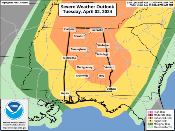
PLACEMENT: First off, all of Alabama is included in a risk of severe weather for this event, so don’t focus too much on the colors of the Storm Prediction Center’s severe weather outlook. All types of severe weather (tornadoes, damaging winds, and large hail) are possible throughout the state. For now, the Storm Prediction Center has expanded the “enhanced risk” (level 3/5) of severe thunderstorms to cover nearly all of Alabama for later today and into the overnight hours.
TIMING: The window for severe storms will open as early as 3PM across northwest portions of Alabama and then the threat will spread south and east through the state during the evening and overnight hours. The severe weather threat will be over with for the state by 5 or 6AM tomorrow.
THREATS: Stronger thunderstorms late this afternoon and tonight will have the potential to produce strong, damaging straight line winds and large hail. Some tornadoes are possible as well. The best dynamics with this system will be over the Ohio Valley, where a potential tornado outbreak is possible later today. But sill in Alabama there are enough ingredients in place that some tornadoes are possible for most of the state, especially within the “enhanced risk”.
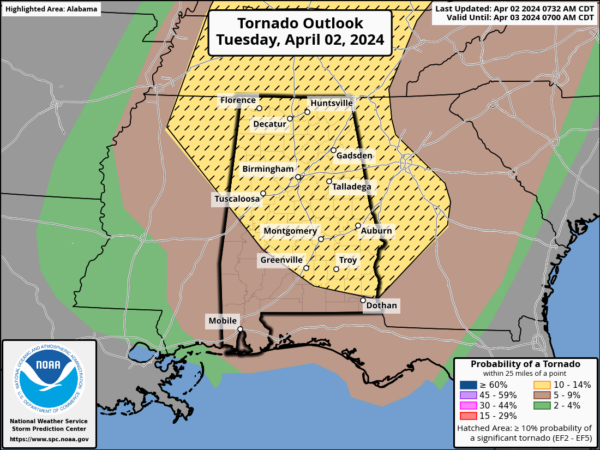
The SPC has a hatched area over Alabama in their tornado outlook, meaning in their opinion a strong tornado (EF-2 or higher) is a possibility. Additionally, winds of 70 mph are possible, and even large hail, up to ping pong ball size could occur.
Best case scenario is that we get away with just strong storms with gusty winds and some hail, but you have to plan on the worst case, which involves potential for a few tornadoes. As the late, great JB Elliot always said, “When it comes to thunderstorms in Alabama, expect the unexpected.”
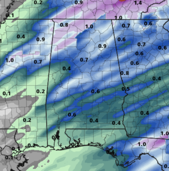
This will be a quick hitting system, and flooding is not expected as rainfall amounts will be in the 1/2 to 1 inch for the northern half of Alabama, and under 1/2 inch for the southern counties of the state. Certainly enough to wash away the current coating of pollen on everything.
CALL TO ACTION: With any severe weather event, but especially an overnight event, be ready to act immediately…Have multiple, reliable ways to receive severe weather alerts, NEVER, ever, ever rely on a outdoor siren. Every Alabama home and business needs a NOAA Weather Radio (the most popular model is the Midland WR-120, which is sold in most local big box retailers). The other way is your phone…be sure emergency alerts are enabled (look under settings, and notifications), and install the free ABC 33/40 Weather app.
Know the safe place in your house, and in that safe place have helmets for everyone. Bicycle helmets and batting helmets work well. We also recommend portable air horns and hard soled shoes for everyone. If you live in an apartment complex, you can’t be above the first level. Shelter with a friend on the ground level, or ask management if they can open the clubhouse during a tornado warning.
If you live in a mobile home, you cannot stay there during a tornado warning, they offer little to know protection from severe storms. Know the location of the nearest shelter, or business that is open 24/7. Know how to get there quickly.
BE A HERO: You can help us. Tell your friends, neighbors, and relatives about the threat, and what they need to do to get ready. And, if they fall in a tornado warning polygon, call them or text them to let them know about the threat. You are our most valuable resource in spreading the word!
Again, this is the core of our severe weather season in Alabama, so events like this are not uncommon. Many of you have anxiety about severe weather, especially those that have gone through tornadoes or other kinds of violent weather. Have comfort knowing that even on the biggest severe weather days, odds of any one home being hit by a tornado are very low. But, you have to pay attention and be prepared. We will get through the event together.
MUCH COOLER REST OF WEEK: Wednesday will be breezy and much cooler with highs in the upper 50s to lower 60s with lingering clouds.Thursday and Friday will be sunny and cool statewide with a high in the 60s, which are below average for the first week of April as average high for Birmingham is 72°.
GROWERS BEWARE: We have the potential for frost over the northern 2/3 of Alabama Friday, and possibly Saturday morning. Colder spots could see a freeze. Growers will need to monitor temperature forecasts and may need to protect sensitive vegetation. Just a point of reference, over the last 30 years, the average last freeze for Birmingham occurs on March 25th. However, during this time frame, the latest last freeze to occur was April 22, 1993. Again, we always say it is best not to plant anything before Tax Day (April 15th) just to be safe. Good news, this will likely be our last cold snap of the season for Alabama.
THE WEEKEND: Dry weather continues over the weekend with lots of sun. Temperatures will begin to moderate as well, as highs look to return to the 70s. Next chance of showers will be at some point around the middle part of the next week and another round of strong storms could be possible by midweek. Tis the season.
ECLIPSE WEATHER: We are less than week away from the eclipse when Alabama will experience a partial solar eclipse next Monday April 8th. For now we are forecasting a partly sunny sky, with temperatures near 70°.
BEACH FORECAST CENTER: Get the latest weather and rip current forecasts for the beaches from Fort Morgan to Panama City on our Beach Forecast Center page. There, you can select the forecast of the region that you are interested in visiting.
WORLD TEMPERATURE EXTREMES: Over the last 24 hours, the highest observation outside the U.S. was 117.9F at Nara, Mali. The lowest observation was -95.6F at Concordia, Antarctica.
CONTIGUOUS TEMPERATURE EXTREMES: Over the last 24 hours, the highest observation was 102F at Carrizo Springs, TX The lowest observation was -5F at Peter Sinks, UT.
Category: Alabama's Weather, ALL POSTS, Severe Weather
About the Author (Author Profile)
Macon, Georgia Television Chief Meteorologist, Birmingham native, and long time Contributor on AlabamaWX. Stormchaser. I did not choose Weather, it chose Me. College Football Fanatic. @Ryan_StinnetSubscribe
If you enjoyed this article, subscribe to receive more just like it.


