Severe Storms Possible Across Alabama Late This Afternoon/Tonight
ACTIVE WEATHER AHEAD: A dynamic weather system will bring showers and thunderstorms into Alabama later today and tonight. SPC maintains an “enhanced risk” (level 3/5) of severe thunderstorms for about the northern third of the state (from Birmingham north), with a “slight risk” (level 2/5) down to the Gulf Coast.

The window for strong to severe thunderstorms opens up around 3:00 p.m. over the northwest corner of the state… storms will move southeastward through the night.
THREATS: Heavier thunderstorms late this afternoon and tonight will have the potential to produce strong, damaging straight line winds and large hail. Also, a few tornadoes are possible, especially in the “enhanced risk” area over North Alabama. But, a tornado can’t be ruled out in other parts of the state.
We note SPC has a hatched area over North Alabama in their tornado outlook, meaning in their opinion a strong tornado (EF-2 or higher) is a possibility.
There is still a good bit of uncertainty in how this all plays out over the next 24 hours; the primary surface low is far north of Alabama, and clouds will likely limit instability values here to some degree. But, high resolution models hint at a secondary surface low forming over Mississippi with a stronger low level jet developing this evening.
Best case scenario is that we get away with just strong storms with gusty winds and some hail, but you have to plan on the worst case, which involves potential for a few tornadoes.
Simply have a reliable way of hearing severe weather warnings (never an outdoor siren!), and have a good plan if you happen to fall in a tornado warning polygon. If you live in a mobile home, know the location of the nearest shelter, and have transpiration available. Having a severe weather threat like this in Alabama during the first week of April is nothing unusual; we will get through the event together.
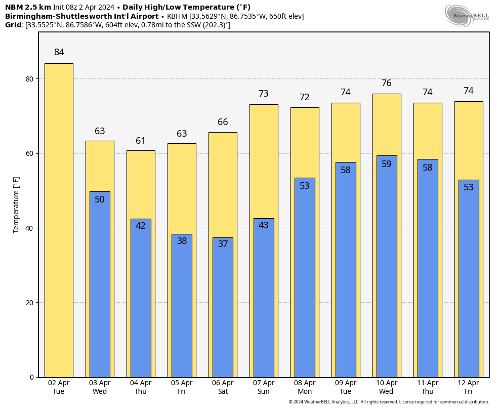
REST OF THE WEEK: Tomorrow will be a breezy and much cooler day for the state with highs in the 60s. Clouds will likely linger much of the day over the northern counties, with lots of sun for the southern part of Alabama. Dry weather continues Thursday and Friday with a good supply of sunshine both days.
FROST/FREEZE POTENTIAL: Lows will drop into the 30s for much of the state Friday and Saturday morning, with a good chance of frost. And, colder spots will have the potential for freezing temperatures. Growers will need to keep a close eye on temperature forecasts. On the positive side, there is a good chance this will be the last frost/freeze threat this season. for most places.
THE ALABAMA WEEKEND: Sunny weather continues over the weekend… the high Saturday will be in the 60s, followed by low to mid 70s Sunday.
NEXT WEEK: The weather looks unsettled for much of the week with some chance of rain on a daily basis. Stronger storms will be possible by mid-week… See the video briefing for maps, graphics, and more details.
ON THIS DATE IN 1957: An F3 tornado tore through Dallas, TX. 10 people were killed, and 216 were injured. Total damage was $1.5 million. This tornado was among the most photographed and studied in history.
ON THIS DATE IN 1982: Severe thunderstorms spawned fifty-six tornadoes in the central U.S., including seventeen in the Red River Region of Texas and Oklahoma. The tornadoes claimed thirty lives and injured 383 other persons. A violent tornado near Messer, Oklahoma left only the carpet tack strips on the slab of a house it destroyed and carried a motel sign thirty miles.
Look for the next video briefing here by 3:00 this afternoon.. enjoy the day!
Category: Alabama's Weather, ALL POSTS, Weather Xtreme Videos
About the Author (Author Profile)
James Spann is one of the most recognized and trusted television meteorologists in the industry. He holds the AMS CCM designation and television seals from the AMS and NWA. He is a past winner of the Broadcast Meteorologist of the Year from both professional organizations.Subscribe
If you enjoyed this article, subscribe to receive more just like it.


