Tornado Watch Issued Until 2 AM for Portions of North/Central Alabama
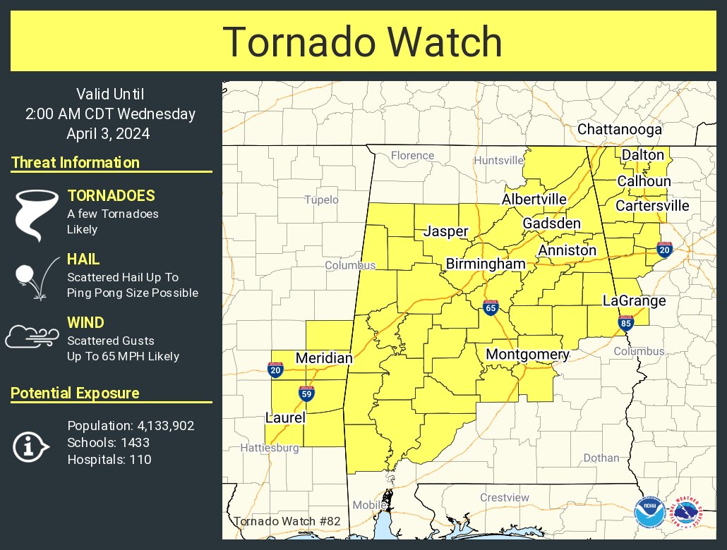
The National Weather Service has issued Tornado Watch 82 until 2 AM CDT Wednesday for 33 counties in central Alabama, including Autauga, Bibb, Blount, Calhoun, Chambers, Cherokee, Chilton, Clay, Cleburne, Coosa, Dallas, Elmore, Etowah, Fayette, Greene, Hale, Jefferson, Lamar, Lowndes, Marengo, Marion, Montgomery, Perry, Pickens, Randolph, Shelby, St. Clair, Sumter, Talladega, Tallapoosa, Tuscaloosa, Walker, and Winston. Stay weather aware and prepared for changing conditions. The Tornado Watch also includes Cullman, DeKalb, Jackson, and Marshall counties in North Alabama.
The NWS Storm Prediction Center has issued a Tornado Watch for portions of Alabama, effective Tuesday night and Wednesday morning from 7:00 PM until 2:00 AM CDT. The primary threats include a few tornadoes likely with a couple of intense tornadoes possible, scattered damaging wind gusts up to 65 mph likely, and scattered large hail events up to 1.5 inches in diameter possible.
Summary: Storms, including supercells, are expected to intensify across the region this evening. Tornado potential will steadily increase after sunset as a low-level jet considerably strengthens.
Remember, a Tornado Watch means conditions are favorable for tornadoes and severe thunderstorms in and close to the watch area. Stay alert and prepared for threatening weather conditions. Listen for later statements and possible warnings.
Category: Alabama's Weather, ALL POSTS, Severe Weather
About the Author (Author Profile)
Scott Martin is an operational meteorologist, professional graphic artist, musician, husband, and father. Not only is Scott a member of the National Weather Association, but he is also the Central Alabama Chapter of the NWA president. Scott is also the co-founder of Racecast Weather, which provides forecasts for many racing series across the USA. He also supplies forecasts for the BassMaster Elite Series events including the BassMaster Classic.Subscribe
If you enjoyed this article, subscribe to receive more just like it.


