Midday Nowcast: Sunshine and Blue Sky
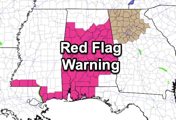
ABSOLUTELY GORGEOUS: The sky is severe clear across Alabama with tons of sunshine and blue sky. It is cool with temperatures in the low to mid 60s, and these are below average for this time of year, as the average high today is 72°. Winds are increasing this afternoon, averaging 10-20 mph with gusts as high as 30 mph, and these make it feel cooler. Combine the winds with the low humidity values in place and you have an increased fire threat; a Red Flag Warning is in effect for most of Alabama. No outdoor burning!!!
BIRMINGHAM ALMANAC: For April 4th, the average high for Birmingham is 72°. The record high is 88° set in 1934, while the record low is 29° set in 1987. We average 0.17” of precipitation on this date, and the record value is 3.75” set in 1957.
ACROSS THE USA: Heavy, wet snow with some significant sleet will continue over north-central New England and northeast New York and then spread north through Maine into Friday. Moderate impacts to travel and power outages are expected. A Pacific system coming onshore Thursday will bring low elevation rain to California and high elevation snow to the Sierras and the Rockies.
FRIDAY & THE WEEKEND: Growers beware, temperatures fall into the 30s tonight, but the winds will likely prevent areas of frost tomorrow morning, but still I’d cover sensitive vegetation. Tomorrow afternoon will be another sunny and cool day with highs in the mid 60s. With lighter winds Saturday morning, and lows in the 30s again, we are more likely to see areas of frost across North/Central Alabama. Saturday will be mainly sunny with highs in the mid to upper 60s. Saturday night will feature lows in the 40s, and Sunday will be mainly sunny with highs in the mid 70s. For the cold weather haters out there, this will likely be our last cold snap of the season for Alabama and temperatures in the 30s may not been seen again in Alabama until November.
NEXT WEEK: Monday will be a mostly cloudy day with a chance of showers, then occasional rain and a few thunderstorms are likely Tuesday and Wednesday as a surface low passes through the region. For now severe storms don’t look likely, but we will keep on eye on trends in the coming days. Rain amounts will be significant with totals of 2-3 inches for the western half of the state; 1-2 inches are likely for the eastern counties. A few lingering showers are possible Thursday, then dry and mild weather is likely Friday through the next weekend with highs will be in the 70s.
ECLIPSE WEATHER: We are four days away from the eclipse when Alabama will experience a partial solar eclipse on Monday April 8th around 2PM CDT. Unfortunately it looks like the sky will be generally cloudy. In the path of totality to the west and north, the best chance of a clear sky is over northern New England and Upstate New York.
BEACH FORECAST CENTER: Get the latest weather and rip current forecasts for the beaches from Fort Morgan to Panama City on our Beach Forecast Center page. There, you can select the forecast of the region that you are interested in visiting.
WORLD TEMPERATURE EXTREMES: Over the last 24 hours, the highest observation outside the U.S. was 119.3F at Kayes, Mali. The lowest observation was -96.9F at Vostok, Antarctica.
CONTIGUOUS TEMPERATURE EXTREMES: Over the last 24 hours, the highest observation was 93F at Hollywood North Perry Airport, FL. The lowest observation was 10F at Peter Sinks, UT.
Category: Alabama's Weather, ALL POSTS
About the Author (Author Profile)
Macon, Georgia Television Chief Meteorologist, Birmingham native, and long time Contributor on AlabamaWX. Stormchaser. I did not choose Weather, it chose Me. College Football Fanatic. @Ryan_StinnetSubscribe
If you enjoyed this article, subscribe to receive more just like it.


