Midday Nowcast: Sunny and Cool Friday
TODAY THROUGH THE WEEKEND: Today is another gorgeous day of weather with sunny, but cool conditions with highs in the mid 60s. Tonight, growers beware, temperatures fall into the 30s, we are likely to see areas of patchy frost across North and Central Alabama; protect any sensitive vegetation. For the cold weather haters out there, this will likely be our last cold snap of the season for Alabama and temperatures in the 30s may not been seen again in Alabama until November.
Tomorrow will be mainly sunny with highs in the mid to upper 60s. Tomorrow night will feature lows in the 40s, and Sunday will be mainly sunny with highs in the mid 70s. By the late afternoon Sunday, clouds will begin to increase and a few showers could reach Northwest Alabama Sunday night.
BIRMINGHAM ALMANAC: For April 5th, the average high for Birmingham is 73° and the average low is 49°. The record high is 88° set in 2010, while the record low is 32° set in 1992. We average 0.18” of precipitation on this date, and the record value is 2.74” set in 1956.
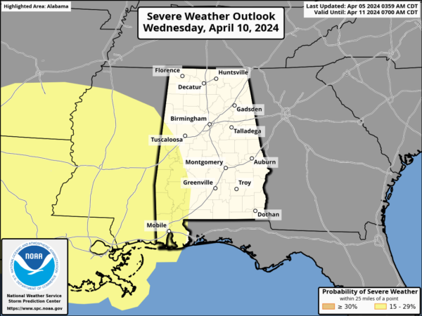
NEXT WEEK: Monday will be a mostly cloudy day with a chance of showers, then occasional rain and a few thunderstorms are likely Tuesday and Wednesday as a surface low passes through the region. There could be a window for stronger storms during this time, so we will keep on eye on trends in the coming days. We note the SPC has portions of Southwest Alabama in a risk of severe weather Wednesday on their “Day 6” convective outlook.
Rain amounts will be significant with totals of 2-3 inches likely for many locations, and some spots could see over three inches. We could see some areas of flooding develop through out the week. The rain and storms will finally push east late Thursday, and dry and mild weather is likely Friday through the weekend. Highs will be in the 70s.
ECLIPSE WEATHER: We are three days away from the eclipse when Alabama will experience a partial solar eclipse Monday afternoon from roughly 12:15 until 3:15; it peaks close to 2:00. Unfortunately it looks like the sky will be mostly cloudy, with perhaps the exception of Southeast Alabama. But, some thin spots are possible over the northern counties as well. And, don’t forget you need the proper eclipse glasses, make sure they are ISO certified.
BEACH FORECAST CENTER: Get the latest weather and rip current forecasts for the beaches from Fort Morgan to Panama City on our Beach Forecast Center page. There, you can select the forecast of the region that you are interested in visiting.
WORLD TEMPERATURE EXTREMES: Over the last 24 hours, the highest observation outside the U.S. was 115.3F at Tambacounda, Senegal. The lowest observation was -95.4F at Vostok, Antarctica.
CONTIGUOUS TEMPERATURE EXTREMES: Over the last 24 hours, the highest observation was 92F at Cotulla and Rio Grande Village, TX. The lowest observation was 4F at Austin, NV.
Category: Alabama's Weather, ALL POSTS
About the Author (Author Profile)
Macon, Georgia Television Chief Meteorologist, Birmingham native, and long time Contributor on AlabamaWX. Stormchaser. I did not choose Weather, it chose Me. College Football Fanatic. @Ryan_StinnetSubscribe
If you enjoyed this article, subscribe to receive more just like it.


