A Late Look at Alabama’s Weather: Severe Storms in Mississippi Should Weaken As They Move Into Alabama
Three mesoscale systems, three convective watches across the South tonight.
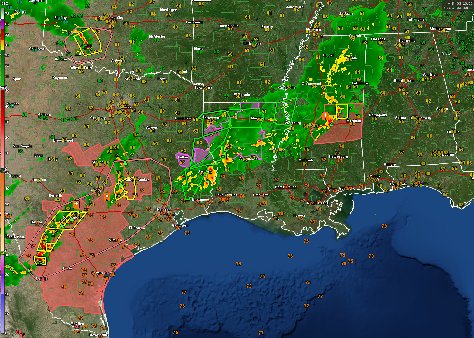
Closest to us here in Alabama is a severe thunderstorm watch for much of Central Mississippi that goes until midnight tonight. An MCS, or mesoscale convective system, is east of Jackson now, extending from Kosciusko to near Brandon down to Hazlehurst. The system is pushing east at 30 mph.
Severe thunderstorm warnings are in effect for parts of Newton and Neshoba Counties in Central Mississippi. There have been several reports of trees and power lines down in Madison County. 1″ hail was reported at Pocahontas in Hinds County. There have been numerous reports of small hail. There have also been reports of flooding.
A possible tornado was reported near Oakley in southern Hinds County. There was a brief TDS near Raymond, indicating brief tornado touch down.
These storms are weakening and are expected to go below severe limits before they reach West Alabama overnight. But we will babysit them just in case.
To the west of that system, storms over East Texas and western Louisiana are pushing east. A tornado watch remains in effect until 11 pm for extreme East Texas and North Central Louisiana. One line of storms extends from west of Natchitoches to near Jasper and Kirbyville.
A tornado warning is in effect for Jasper, Hardin, and Tyler counties in East Texas south of the City of Jasper.
These storms will reach Alabama after 8 am tomorrow, but again, they will be falling apart.
Other storms are over northern Louisiana now from west of Bernice to Minden to south of Shreveport. They are not severe at this time. Those are of no consequence to us in Alabama.
Finally, storms in the Texas Hill Country have prompted a severe thunderstorm watch for Central and South Texas tonight. Lots of reports of large hail from Temple to Round Rock to Hondo to the Mexican border. Severe thunderstorm warnings are in effect for places like Big Wells, western San Antonio, and areas southwest of College Station.
These storms will cross southern Louisiana during the morning hours and get into Southwest Alabama by late morning, by which time they will be re-intensifying. There is a severe weather threat for South Alabama, mainly south of a line from Eutaw to Marion to Montgomery to Clayton. There is a marginal risk south of a line from Vernon to Bessemer to Tuskegee to Eufaula.
But high resolution guidance tonight indicates that the severe weather threat is not major. It certainly is higher the further south and southwest you go in Alabama into the Panhandle. I will note that the SPC Day Two for tomorrow is much more ominous. And the situation can change, so pay very close attention to updates tomorrow.
But for tonight, set your Weatheradio and go to bed.
It will be windy tomorrow, with wind gusts to 40 mph even away from storms.
A flash flood watch is in effect for the northern two thirds of the state tomorrow as well. Rainfall amounts of 2-4 inches will be common with isolated higher amounts.
Category: Alabama's Weather, ALL POSTS, Severe Weather
About the Author (Author Profile)
Bill Murray is the President of The Weather Factory. He is the site's official weather historian and a weekend forecaster. He also anchors the site's severe weather coverage. Bill Murray is the proud holder of National Weather Association Digital Seal #0001 @wxhistorianSubscribe
If you enjoyed this article, subscribe to receive more just like it.


