Windy, Wet, Stormy Weather For Alabama Through Tonight
ACTIVE WEATHER DAY: Light rain is falling early this morning over the northern third of the state, otherwise the sky is mostly cloudy with temperatures generally in the 60s.
SEVERE STORM POTENTIAL: Rain becomes more widespread across Alabama this afternoon and tonight, along with the potential for strong thunderstorms. We believe the main risk of severe storms will be across far South Alabama and the Florida Panhandle, along and south of a line from Grove Hill to Evergreen to Headland. A few isolated severe storms are possible as far north as U.S. 80 (Demopolis to Selma to Montgomery to Opelika).
The window for severe storms opens up around 12 noon across far Southwest Alabama, with the storms progressive eastward during the afternoon and evening hours. The storms should be out of the southeast corner of the state by 2 a.m.
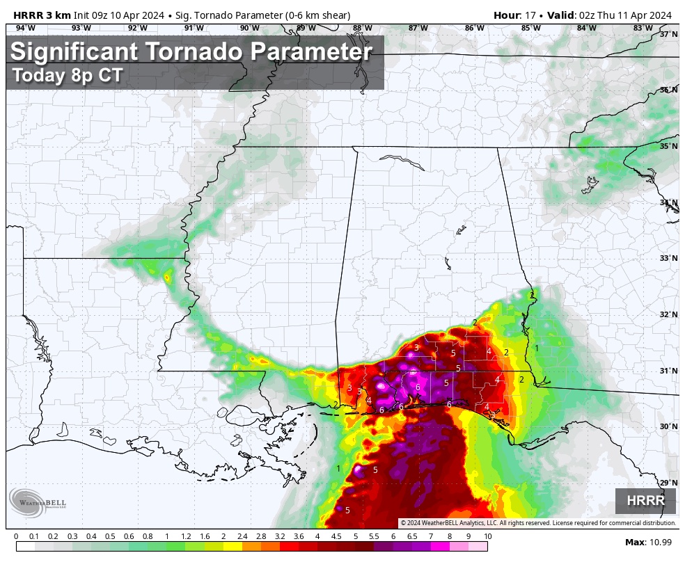
Storms over South Alabama this afternoon and tonight will be capable of producing strong, possible damaging winds, and a few isolated tornadoes. As always, have a reliable way of hearing severe weather warnings and have a good plan.
For the northern half of Alabama, there will be no surface based instability, and the chance of severe thunderstorms is very low.
RAIN AMOUNTS: The good news is that the amount of rain expected over the northern half of the state is now much lower, generally one inch or less. Heaviest rain will be over South Alabama, where amounts around two inches are likely. A flash flood watch remains in effect there.
GRADIENT WIND: Non-thunderstorm winds will ramp up statewide today, gusting as high as 35/40 mph in spots. There is also the chance a “wake low” forms on the back edge of the big rain mass this evening, which could lead to higher gusts due to the tight gradient.
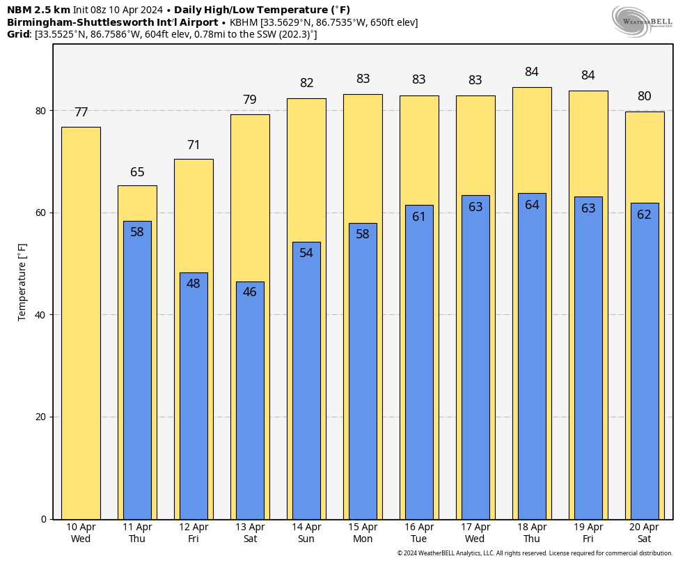
Tomorrow will be a mostly cloudy, breezy, and cooler day with a few lingering showers; the highs will be in the 60s for most communities. Best chance of seeing some sun tomorrow is over the southern third of the state.
FRIDAY AND THE WEEKEND: The weather will be dry with sunny days and fair nights. The high Friday will be in the low 70s, followed by 80 degree warmth Saturday and Sunday. Coolest morning will come early Saturday with lows down in the 40s.
NEXT WEEK: An upper ridge will set the stage for the warmest week so far this year with daily highs in the 80-85 degree range. The ridge will also keep the big rain producers west and north of the Deep South… the week looks dry. See the video briefing for maps, graphics, and more details.
ON THIS DATE IN 1979: This day was known as “Terrible Tuesday” to the residents of Wichita Falls, Texas as a tornado rated F4 on the Fujita scale ripped through the city. A massive F4 tornado smashed into Wichita Falls killing 43 persons and causing 300 million dollars in damage. Another tornado struck Vernon, Texas killing eleven persons.
Look for the next video briefing here by 3:00 this afternoon… enjoy the day!
Category: Alabama's Weather, ALL POSTS, Weather Xtreme Videos
About the Author (Author Profile)
James Spann is one of the most recognized and trusted television meteorologists in the industry. He holds the AMS CCM designation and television seals from the AMS and NWA. He is a past winner of the Broadcast Meteorologist of the Year from both professional organizations.Subscribe
If you enjoyed this article, subscribe to receive more just like it.


