Midday Nowcast: Windy, Wet, and Stormy Wednesday for Alabama
FLOOD WATCH: Has been trimmed back some, but still includes most of Central and South Alabama as heavy rainfall the next 12-18 hours could bring flooding issues to the state. Rainfall potential remains in the 2-4 inch range, with isolated higher amounts, mainly south of Birmingham.
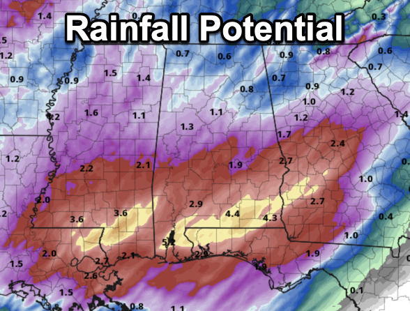
We could see flash flooding and flooding issues, plus rivers and stream could see much higher flows.

For northern portions of the state, rain amounts will be closer to one inch, with little to no flooding issues anticipated. But of course we will watch rainfall trends through this event.
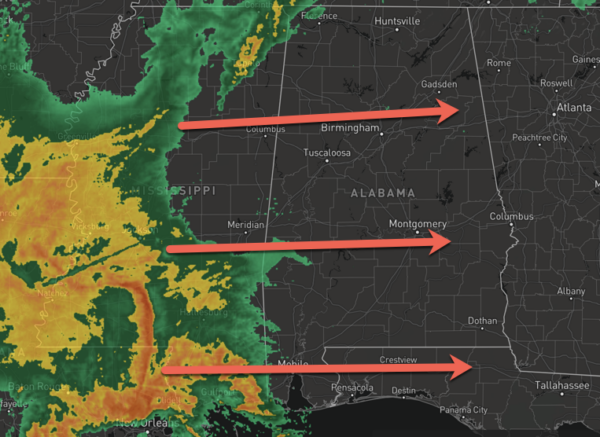
STORM THREAT: Some strong to severe storms remain possible through the afternoon and evening hours as the dynamic storm system moves through the Deep South. However, there is not a lot of instability across much of Alabama today, as the best instability remains near the immediate coast. We continue to believe the main risk of severe storms will be across far South Alabama and the Florida Panhandle, along and south of a line from Grove Hill to Evergreen to Headland. A few isolated severe storms are possible as far north as U.S. 80 (Demopolis to Selma to Montgomery to Opelika).
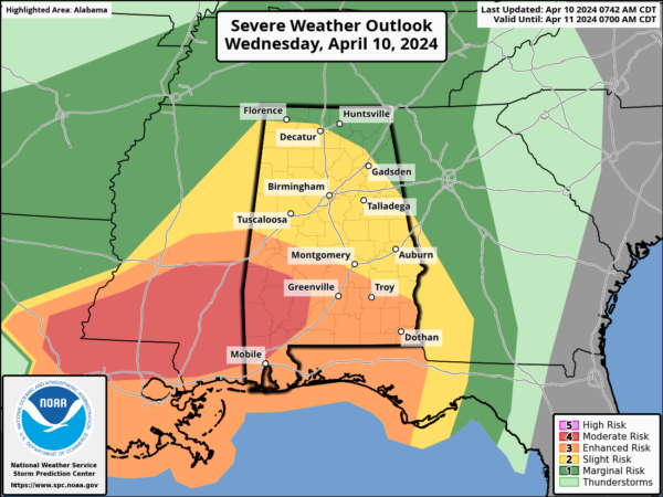
Storms over South Alabama this afternoon and tonight will be capable of producing strong, damaging winds, and a few isolated tornadoes. As always, have a reliable way of hearing severe weather warnings and have a good plan. For the northern half of Alabama, there will be no surface based instability, and the chance of severe thunderstorms is very low.
GRADIENT WIND: Non-thunderstorm winds are ramping up statewide today, gusting as high as 35/40 mph in spots. There is also the chance a “wake low” forms on the back edge of the big rain mass this evening, which could lead to higher gusts due to the tight gradient. These winds could certainly bring down trees down and cause power issues later today.
The heavy rainfall and strong storm threat will be winding down by midnight for much of Alabama.
BIRMINGHAM ALMANAC: For April 10th, the average high for Birmingham is 74° and the average low is 51°. The record high is 88° set in 1995, while the record low is 29° set in 1996. We average 0.18” of precipitation on this date, and the record value is 1.74” set in 2015.
Tomorrow will be a mostly cloudy, day with some risk of lingering showers over the northern half of the state. It will be cooler and breezy, and temperatures will struggle to climb out of the 60s.
FRIDAY & THE WEEKEND: Friday will feature tons of sunshine and highs in the low 70s. The weekend will be warm and dry with lots of sun Saturday and Sunday along with afternoon highs around 80°. Lows will be in the 40s Saturday morning, followed, by 50s Sunday morning.
NEXT WEEK: An upper ridge will set the stage for the warmest week so far this year with daily highs in the low to mid 80s. There could even be some upper 80s across South Alabama through the week. The ridge will also keep the big rain producers west and north of the Deep South and the week looks dry.
BEACH FORECAST CENTER: Get the latest weather and rip current forecasts for the beaches from Fort Morgan to Panama City on our Beach Forecast Center page. There, you can select the forecast of the region that you are interested in visiting.
WORLD TEMPERATURE EXTREMES: Over the last 24 hours, the highest observation outside the U.S. was 122.4F at Joba, Oman. The lowest observation was -94.9F at Dome A, Antarctica.
CONTIGUOUS TEMPERATURE EXTREMES: Over the last 24 hours, the highest observation was 101F at Zapata, TX. The lowest observation was 0F at Peter Sinks, UT.
Category: Alabama's Weather, ALL POSTS, Severe Weather
About the Author (Author Profile)
Macon, Georgia Television Chief Meteorologist, Birmingham native, and long time Contributor on AlabamaWX. Stormchaser. I did not choose Weather, it chose Me. College Football Fanatic. @Ryan_StinnetSubscribe
If you enjoyed this article, subscribe to receive more just like it.


