

Midday Nowcast: Some Showers and Storms
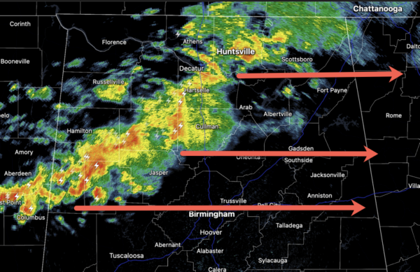
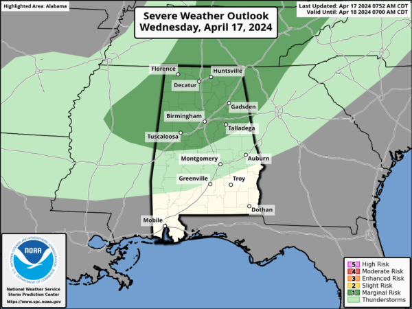
Showers and storms are continuing to push east through North/Central Alabama late this morning and into the afternoon as a dynamic storm system passes well north of Alabama. The SPC has a Level 1 risk of severe storms for the northern half of Alabama today, but we are not expecting much of a severe threat, and any threat would come from hail and gusty winds.
Rain amounts will be near 1/2 inch where the rain falls, but many locations will remain dry. We note some lightning is showing up on the radar, so make sure you are not outdoors when the showers and storms roll through. With the added clouds, we are only seeing highs in the upper 70s to low 80s.
Tomorrow will be dry with temperatures surging into the mid and upper 80s, and should be the warmest day for most of Alabama so far this year. Showers are possible tomorrow night ahead of another front.
BIRMINGHAM ALMANAC: For April 17th, the average high for Birmingham is 75° and the average low is 52°. The record high is 90° set in 1955, while the record low is 33° set in 1986. We average 0.17” of precipitation on this date, and the record value is 2.80” set in 1900.
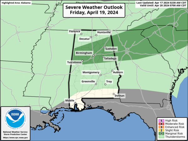
FRIDAY AND THE WEEKEND: We will mention a chance of widely scattered showers and possibly a thunderstorm Friday, but a decent part of the day should be dry with a high in the low 80s, a few strong storms are possible, but like today, we are not expecting much in the way of a severe threat.
The front will sag southward over the weekend, and moisture will ride up and over the cool air behind the front, meaning periods of rain both Saturday and Sunday. There could be a rumble of thunder, but no risk of severe storms, and rain amounts should be mostly 1/2 inch or less.
There will be some breaks in the rain, and the weekend won’t be a total wash-out. Temperatures will trend cooler; the high Saturday will be in the 70s, and then on Sunday many communities across North Alabama will have a hard time getting out of the 50s with 60s expected for Central Alabama.
RACE WEEKEND: The sky will be mostly cloudy at Talladega over the weekend with occasional showers both days. No way at this point to know the exact timing of the rain, but just understand delays will be possible for the races Saturday, and the Geico 500 Sunday. No wash-out, but be ready for some rain at times. The high Saturday will be in the mid 70s, followed by low 60s Sunday with a cool north breeze. Some thunder can’t be ruled out, but there is no risk of severe storms, and rain amounts should be fairly light.
NEXT WEEK: Most of the week will be dry with a warming trend; the high will be close to 80 by Wednesday. Still no sign of any high impact weather event (severe storms, flooding) for at least the next 7-10 days for Alabama.
BEACH FORECAST CENTER: Get the latest weather and rip current forecasts for the beaches from Fort Morgan to Panama City on our Beach Forecast Center page. There, you can select the forecast of the region that you are interested in visiting.
WORLD TEMPERATURE EXTREMES: Over the last 24 hours, the highest observation outside the U.S. was 116.2F at Maine-Soroa, Niger. The lowest observation was -99.6F at Vostok, Antarctica.
CONTIGUOUS TEMPERATURE EXTREMES: Over the last 24 hours, the highest observation was 111F at Rio Grande Village, TX. The lowest observation was 14F at Berthoud Pass, CO.
Category: Alabama's Weather, ALL POSTS
About the Author (Author Profile)
Macon, Georgia Television Chief Meteorologist, Birmingham native, and long time Contributor on AlabamaWX. Stormchaser. I did not choose Weather, it chose Me. College Football Fanatic. @Ryan_StinnetSubscribe
If you enjoyed this article, subscribe to receive more just like it.


