Midday Nowcast: Warm, Muggy Days; High Risk of Severe Storms for Plains Today
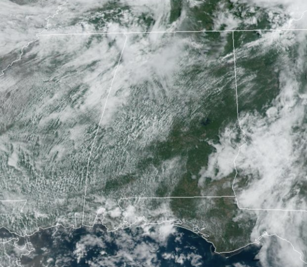
The morning rain and storms have moved out of the state, but more showers and storms are expected this afternoon. The rest of today we are seeing a mix of sun and clouds today with afternoon highs in the mid to upper 80s. Not much change in the weather tomorrow as we will again see a partly sunny sky with highs in the mid to upper 80s. Scattered, random showers and storms will once again be on the radar tomorrow across the state, mainly during the afternoon and evening hours.
A few strong storms are possible, and we note the SPC has a “marginal risk” (level 1 of 5) of severe storms tomorrow for much of the state. If there are any severe storms, the threats will be hail and gusty winds. Of course, warm season storms are prolific rain producers, so don’t be surprised if there are areas of isolated flash flooding.
BIRMINGHAM ALMANAC: For May 6th, the average high for Birmingham is 80° and the average low is 58°. The record high is 92° set in 1952, while the record low is 38° set in 1968. We average 0.16” of precipitation on this date, and the record value is 3.85” set in 1967.
SEVERE WEATHER OUTBREAK: A major severe weather outbreak is expected today and tonight across the Plains. Multiple strong, long-tracked tornadoes, as well as very large hail and severe thunderstorms gusts are expected.
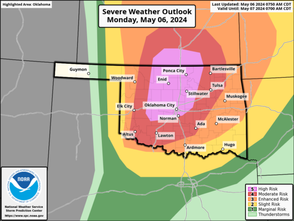
The Storm Prediction Center has issues are “High Risk” (level 5 of 5) of severe storms today for portion of Oklahoma and Kansas. The High Risk includes the Oklahoma City and Wichita Metropolitan areas.
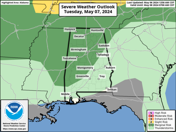
WEDNESDAY/THURSDAY: Wednesday will likely be the warmest day so far this year with many places touching 90°. This will make the air unstable, and will open the door for more strong to severe thunderstorms by afternoon and into Wednesday night.
The SPC has defined a severe weather threat for the northern half of the state, and the main concern will come from hail and strong winds. The main dynamic support/wind profiles needed for tornadoes will be north and west of Alabama based on current model data.
Some showers or thunderstorms are possible Thursday; for now no severe weather risk is defined since the air could be worked over by storms Wednesday night. The high Thursday will be in the mid 80s.
MARVELOUS MOTHER’S DAY WEEKEND: A refreshing, cool, dry airmass will drop into Alabama, setting the stage for sunny pleasant days and clear cool nights. Highs will be mostly in the 70s, with lows in the 50s. Colder spots across North Alabama could easily dip into the 40s Saturday morning. Enjoy these temperatures, as this could be the last time we see lows in the 40s and 50s until October or November.
BEACH FORECAST CENTER: Get the latest weather and rip current forecasts for the beaches from Fort Morgan to Panama City on our Beach Forecast Center page. There, you can select the forecast of the region that you are interested in visiting.
WORLD TEMPERATURE EXTREMES: Over the last 24 hours, the highest observation outside the U.S. was 128.1F at Joba, Oman. The lowest observation was -101.9F at Concordia, Antarctica.
CONTIGUOUS TEMPERATURE EXTREMES: Over the last 24 hours, the highest observation was 97F at Rio Grande Village, TX. The lowest observation was 10F at Berthoud Pass, Monarch Pass, and Wolf Creek Pass, CO.
Category: Alabama's Weather, ALL POSTS
About the Author (Author Profile)
Macon, Georgia Television Chief Meteorologist, Birmingham native, and long time Contributor on AlabamaWX. Stormchaser. I did not choose Weather, it chose Me. College Football Fanatic. @Ryan_StinnetSubscribe
If you enjoyed this article, subscribe to receive more just like it.


