

Strong Storms This Morning; More Storms Possible Tonight/Early Tomorrow
RADAR CHECK: A line of thunderstorms is pushing southward through the Tennessee Valley early this morning. So far most of the storms have remained below severe limits, but we note a tornado watch is in effect until 10am for areas north of a line from Millport to Jasper to Cullman to Fort Payne.
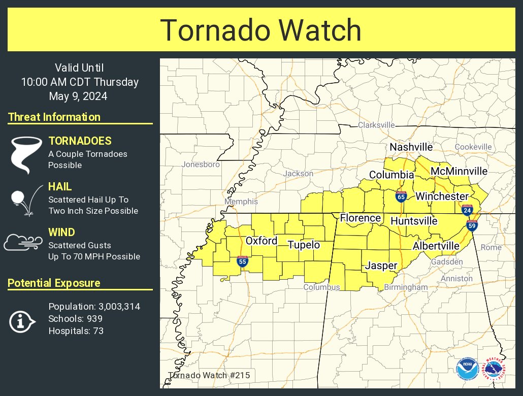
The main concern this morning involves strong thunderstorm winds, but a brief, isolated tornado can’t be ruled out. The storms will continue to move southward, reaching the I-20/59 corridor by 8/9 a.m. (Tuscaloosa, Birmingham, Anniston, Gadsden). They drift into southeast Alabama by early afternoon.
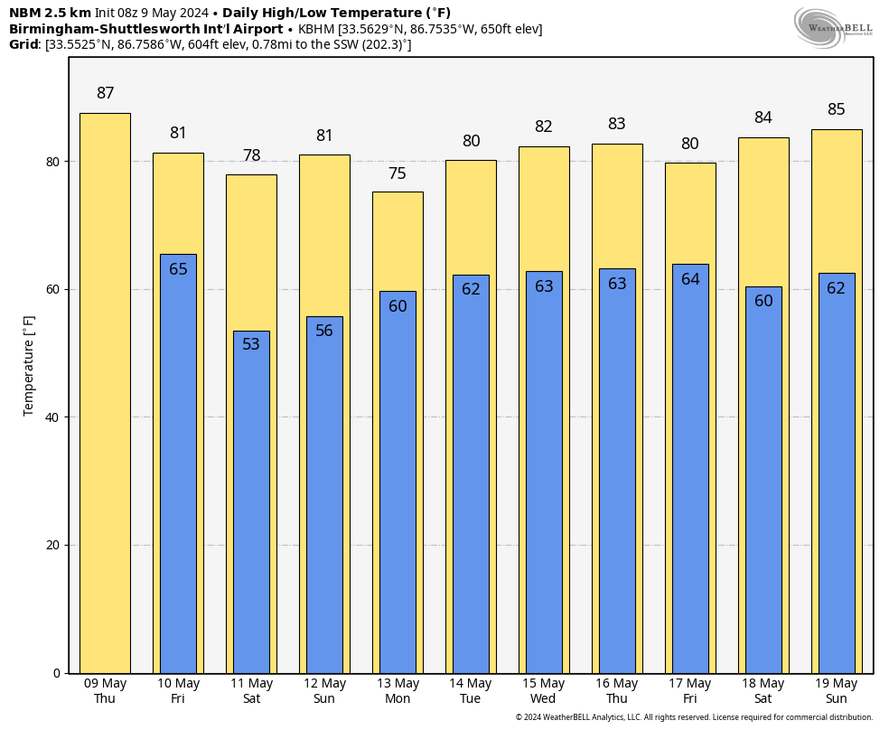
Much of the state will be dry during the afternoon and evening hours, with some sun along with highs in the mid to upper 80s.
TONIGHT: Another batch of rain and storms is expected to develop over the southern 2/3 of Alabama tonight, generally after 9:00 p.m. These storms, where they form, will be capable of producing damaging winds. An isolated tornado or two is also possible. The highest coverage of storms will likely be south of I-20 (Tuscaloosa to Birmingham to Anniston), and especially south of U.S. 80 (Demopolis to Selma to Montgomery to Opelika).
SPC has a level 3/5 “enhanced risk” defined for this potential tonight over much of Central and South Alabama.
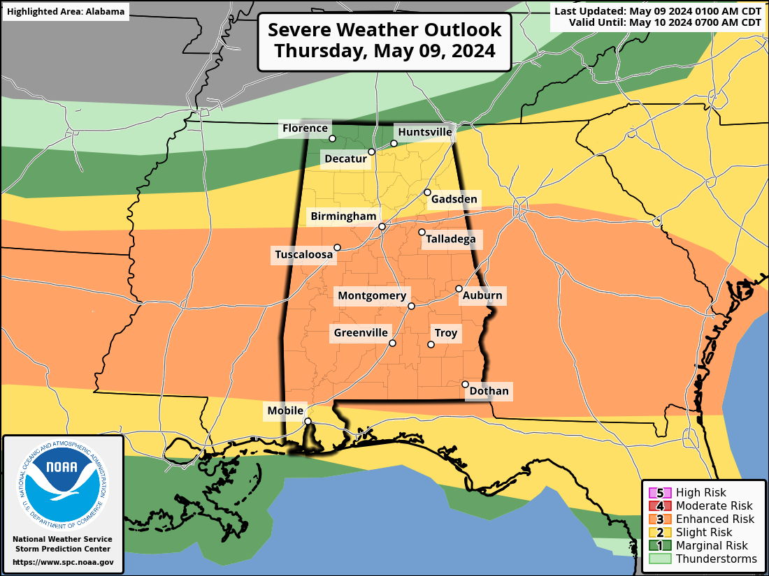
The storms will linger into early tomorrow morning over Southeast Alabama, and should be out of the state by mid-morning. Otherwise, tomorrow will feature a clearing sky with a high around 80 degrees.
THE ALABAMA WEEKEND: A cool, dry continental airmass will cover Alabama Saturday. We start the day with a low in the 47-55 degree range… then with a sunny sky the high will be in the upper 70s over the northern counties, with low 80s to the south. Sunday will be another mostly sunny day with a high in the low 80s for most communities.
NEXT WEEK: Showers and a few thunderstorms return to Alabama Monday into Tuesday morning. Then, after a dry day Wednesday, occasional showers and storms are likely Thursday and Friday. See the video briefing for maps, graphics, and more details.
ON THIS DATE IN 1933: An estimated F4 tornado moved through Monroe, Cumberland, and Russell Counties in Kentucky along a 60-mile path. The town of Tompkinsville, KY was the hardest hit with 18 people killed.
Look for the next video briefing here by 3:00 this afternoon… enjoy the day!
Category: Alabama's Weather, ALL POSTS, Weather Xtreme Videos
About the Author (Author Profile)
James Spann is one of the most recognized and trusted television meteorologists in the industry. He holds the AMS CCM designation and television seals from the AMS and NWA. He is a past winner of the Broadcast Meteorologist of the Year from both professional organizations.Subscribe
If you enjoyed this article, subscribe to receive more just like it.


