Midday Nowcast: A Couple of Dry Days; More Rain and Storms Return Friday
Drier air is moving into Alabama today and will continue into tomorrow. Both these days will be mainly dry with only a few isolated showers over the northeastern portions of the state today. Highs today and tomorrow will range from the low to mid 80s with more sun than clouds.
BIRMINGHAM ALMANAC: For May 15th, the average high for Birmingham is 82° and the average low is 61°. The record high is 94° set in 1899, while the record low is 43° set in 1917. We average 0.16” of precipitation on this date, and the record value is 3.00” set in 1983.
RAIN AND STORMS RETURN: Rain returns to Alabama during the day Friday ahead of the next storm system. Some showers are possible Friday morning, the more widespread rain and storms will come Friday afternoon and Friday night. The SPC has defined a “slight risk” (level 2/5) of severe thunderstorms for parts of West and Southwest Alabama, while the rest of the state is in a “marginal risk” (level 1/5).
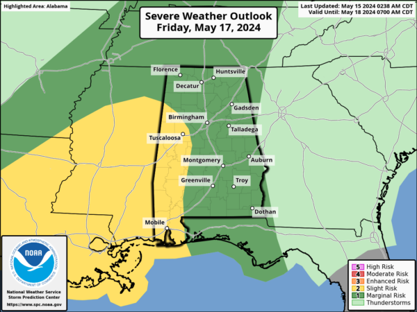
There is a good bit of uncertainty involving how the storm environment evolves. For now it looks like the higher chance of severe thunderstorms will be over the southern portions of the state, where better instability values will be in place. The main threats will come from strong, potentially damaging straight line winds and hail, but an isolated tornado is certainly possible.
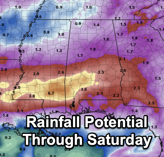
Rain could also be heavy at times late Friday and Friday night, some flooding issues could develop over the southern half of the state and rainfall potential for southern sections of the state will be in the 3-4 inch range, while 1-2 inches are possible for northern half of the state.
WEEKEND WEATHER: The weather looks to improve through the day Saturday. The day should start off wet but the rain should end during the morning, and we expect a clearing sky Saturday afternoon. Sunday should feature sunshine in full supply. Highs will be in the lower 80s Saturday, followed by upper 80s Sunday.
NEXT WEEK: An upper ridge will build over the region, and for now a decent part of next week looks dry with highs in the mid to upper 80s and more and more 90s will start to show up on the maps. Though most of the week looks dry, a few scattered showers will be possible, especially on Wednesday.
BEACH FORECAST CENTER: Get the latest weather and rip current forecasts for the beaches from Fort Morgan to Panama City on our Beach Forecast Center page. There, you can select the forecast of the region that you are interested in visiting.
WORLD TEMPERATURE EXTREMES: Over the last 24 hours, the highest observation outside the U.S. was 117.9F at Matam, Senegal. The lowest observation was -86.1F at Concordia, Antarctica.
CONTIGUOUS TEMPERATURE EXTREMES: Over the last 24 hours, the highest observation was 106F at Death Valley, CA. The lowest observation was 22F at Covington, MI.
Category: Alabama's Weather, ALL POSTS
About the Author (Author Profile)
Macon, Georgia Television Chief Meteorologist, Birmingham native, and long time Contributor on AlabamaWX. Stormchaser. I did not choose Weather, it chose Me. College Football Fanatic. @Ryan_StinnetSubscribe
If you enjoyed this article, subscribe to receive more just like it.


