Sunday Weather Video Briefing: Drier Through Midweek
Saturday worked out to be a fairly stormy day as scattered showers and storms developing in the heating of the day, aided by an upper level low just to our northwest. Some of the storms became severe, mainly with large hail, but there were a couple of wind damage reports as well. Rainfall was heavy in spots, but didn’t get out of control.
ON THE WEATHER MAPS: The upper low from yesterday has opened up into a trough this morning with the axis over Georgia and the Carolinas. This trough will move offshore of the East Coast over the next 24 hours and upper level high pressure will set up shop from Texas to New England. At the surface, the boundary that has been over South Alabama will move about midway down the Florida Peninsula, but low pressure will spin up along it, and this could throw a shower back into eastern sections of Alabama overnight. But overall, the day and the overnight will feature lower humidity, fewer clouds and few if any showers. Highs today will be in the lower and middle 80s. Lows tonight will be in the lower and middle 60s. Quite refreshing. Maybe the last time you will hear me say that until September.
TRANQUIL THROUGH MIDWEEK: Alabama’s weather will be nice through Wednesday as that upper level ridge holds strong. Daytime highs will start to warm toward summerlike readings, with highs climbing into the middle and upper 80s. Lows will be in the 60s each morning.
LATE WEEK FRONT: The ridge will break down enough enough by Thursday for a few showers and storms to edge down into North and Central Alabama Thursday afternoon. The front and its attendant showers and storms may push a little further south into Alabama on Friday.
WEEKEND OUTLOOK: Saturday should be drier, although a few showers could break out over eastern sections of the state. Another front will edge towards Alabama on Sunday, bringing additional showers and storms to the northern half of the area. Highs with be in the 80s and lows will be in the upper 60s.
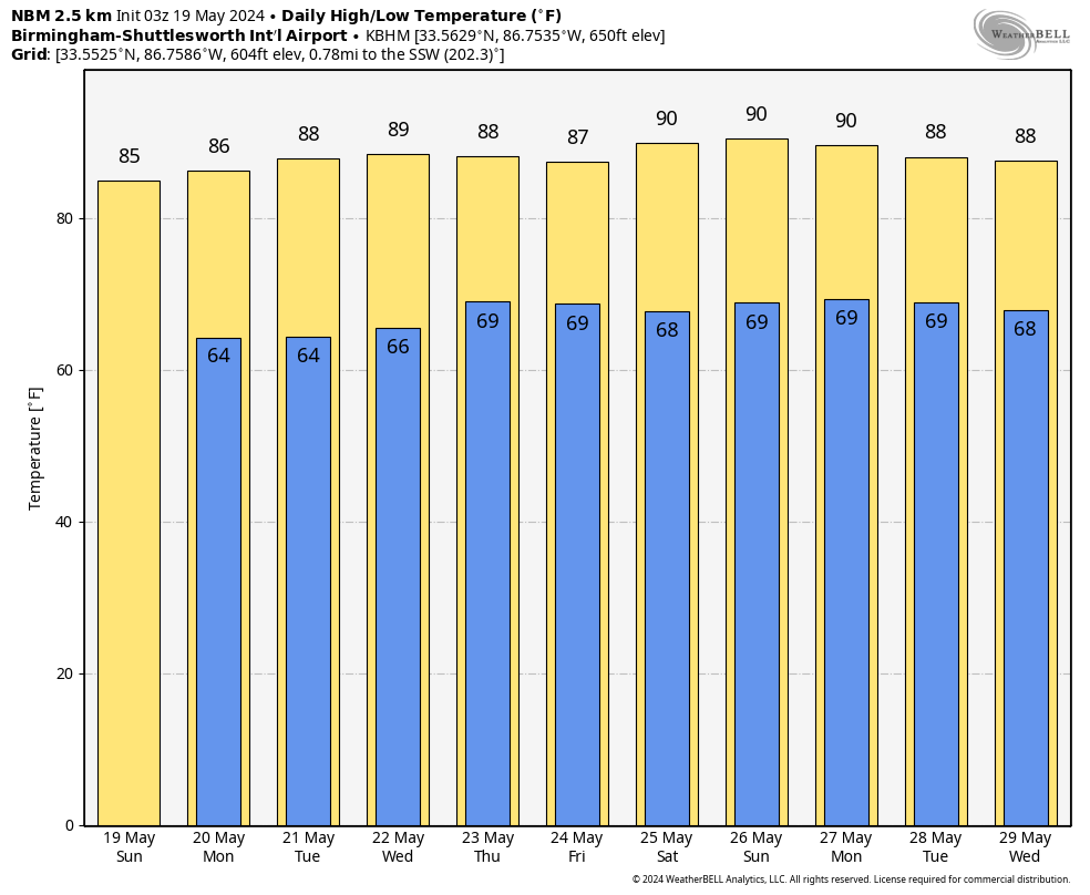
HOLIDAY FORECAST: The front will edge back north as a warm front on Monday, meaning showers and storms will be limited to the Tennessee Valley. It will be warm, with highs in the 80s still. Overnight lows will be in the 60s.
VOODOO COUNTRY: Things look unsettled in the Week Two period with showers and storms each day. Highs will be around 90F. Lows will be near 70F.
BEACH FORECAST CENTER: Please visit our Beach Forecast Center page to access the most up-to-date weather and rip current forecasts for the beaches spanning from Fort Morgan to Panama City. On this platform, you can choose the forecast specific to the region you intend to visit, ensuring you have accurate and relevant information for your plans.
E-FORECAST SIGN UP: Receive the Alabama Weather Blog’s comprehensive Seven-Day Forecast directly to your inbox via email, delivered twice daily. Recognized as the most detailed weather forecast accessible in Central Alabama, our service ensures you stay informed and prepared. Subscribe now to access this valuable resource at no cost!
Category: Alabama's Weather, ALL POSTS, Severe Weather
About the Author (Author Profile)
Bill Murray is the President of The Weather Factory. He is the site's official weather historian and a weekend forecaster. He also anchors the site's severe weather coverage. Bill Murray is the proud holder of National Weather Association Digital Seal #0001 @wxhistorianSubscribe
If you enjoyed this article, subscribe to receive more just like it.


