Hottest Weather So Far This Year By The Weekend
COOL START: Here are some of the cooler temperatures across Alabama early this morning just before sunrise…
Fort Payne 53
Cullman 54
Gadsden 55
Morris 56
Jasper 57
Pell City 57
Chelsea 58
Trussville 58
Decatur 59
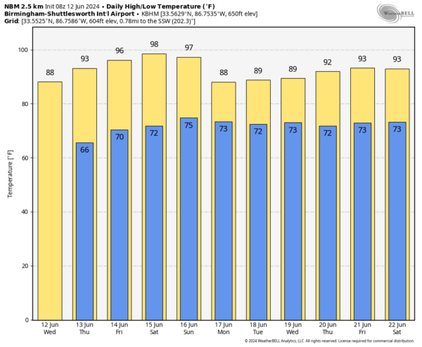
This could be the last time we see lows in the 50s until the fall. Today will be a sunny day with a high in the 88-92 degree range.
RISING HEAT LEVELS: The weather stays dry tomorrow through Saturday with mostly sunny days, fair nights, and a warming trend. Highs will be in the 90s, and by Saturday some spots might even touch the 100 degree mark. Heat index values will be over 100 degrees over the weekend.
Moisture levels rise a bit Sunday, and we will bring in the chance of a few scattered showers, but for now we aren’t expecting anything especially widespread.
NEXT WEEK: We will maintain the chance of a few showers on a daily basis through the week, but the deepest moisture will likely be west of Alabama. Rain amounts will be light and spotty; the higher rain coverage will be over the southern counties, but even there no wash-out. Heat levels drop with highs in the upper 80s and low 90s through the week. See the video briefing for maps, graphics, and more details.
TROPICS: A broad and elongated area of low pressure near the west-central coast of Florida is producing a large area of disorganized showers and thunderstorms. This system has moved little over the past few hours, but is expected to move northeastward across Florida and move offshore of the U.S. Southeast coast within the next day or so. Although upper-level winds are expected to be only marginally conducive, some slow development is possible while the system moves offshore of the U.S. Southeast coast. Regardless of development, heavy rainfall is forecast to continue across portions of the Florida peninsula during the next few days.
The chance of development over the next seven days is only 20 percent, and this feature will not impact the Central Gulf Coast (Gulf Shores over to Panama City Beach).
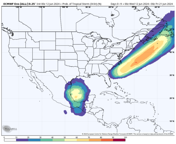
We do note the European global model suggests some potential for tropical storm formation in the far Southwest Gulf of Mexico in a week or so; it moves the tropical low into Mexico. Again, no impact on the Central Gulf Coast.
ON THIS DATE IN 1915: An estimated F4 tornado moved northeast from northwest of Waterville, Iowa crossing the Mississippi River two miles south of Ferryville, Wisconsin. A man and his daughter were killed in one of three homes that were obliterated southwest of “Heytman,” a small railroad station on the Mississippi River.
Look for the next video briefing here by 3:00 this afternoon… enjoy the day!
Category: Alabama's Weather, ALL POSTS, Weather Xtreme Videos


