Rain Chances Rise Later This Week With Lower Heat Levels
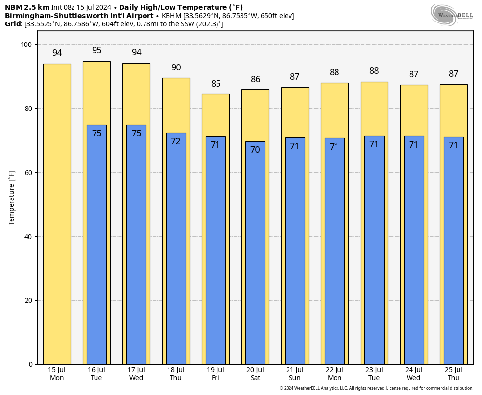
HOT SUMMER DAY AHEAD: We have some very classic summer weather for Alabama today and tomorrow. Partly sunny and hot with a few random scattered showers and thunderstorms around, mainly this afternoon and early tonight. Highs will be in the mid 90s, and the chance of any one location seeing rain is 25-35 percent.
Scattered showers and storms will begin to increase in number on Wednesday as the air becomes more unstable, and by Thursday and Friday we expect numerous showers and storms around. As always in summer, rain distribution won’t be very even, but the chance of rain for your front yard is 55-65 percent Wednesday, and near 70 percent Thursday and Friday. Highs drop into the 85-90 degree range Thursday and Friday because of clouds and rain.
THE ALABAMA WEEKEND: The weather stays unsettled with a good chance of occasional showers and thunderstorms Saturday and Sunday. The weekend won’t be a wash-out by any means, but rain is likely at times with highs only in the mid 80s.
We don’t expect much change through much of next week, with the opportunity of scattered to numerous showers and thunderstorms on a daily basis. This pattern has the potential to bring beneficial rain to the state, in fact reliable guidance from the European global model suggests a little over 4 inches of rain for much of Alabama through the rest of July. Highs next week will be in the 80s the northern 2/3 of the state, well below average. See the video briefing for maps, graphics, and more details.
TROPICS: Visible satellite imagery shows the large SAL (Sarahan Air Layer) covering much of the Atlantic basin. This is a mass of very dry, dusty air that forms over the Sahara Desert during the late spring, summer and early fall. The warmth, dryness and strong winds associated with the SAL suppress tropical cyclone formation and intensification. Accordingly, tropical storm/hurricane formation is not expected for at least the next seven days.
ON THIS DATE IN 1901: The city of Marquette, Michigan set their all-time record high temperature with 108 degrees F.
ON THIS DATE IN 2003: Hurricane Claudette made landfall along the middle Texas coast near Port O’Connor with winds of 85 mph. Two deaths (both from falling trees or tree limbs) have been attributed to Hurricane Claudette.
Look for the next video briefing here by 3:00 this afternoon… enjoy the day!
Category: Alabama's Weather, ALL POSTS, Weather Xtreme Videos
About the Author (Author Profile)
James Spann is one of the most recognized and trusted television meteorologists in the industry. He holds the AMS CCM designation and television seals from the AMS and NWA. He is a past winner of the Broadcast Meteorologist of the Year from both professional organizations.Subscribe
If you enjoyed this article, subscribe to receive more just like it.


