A Little Less Heat Today; A Few Scattered Storms Possible
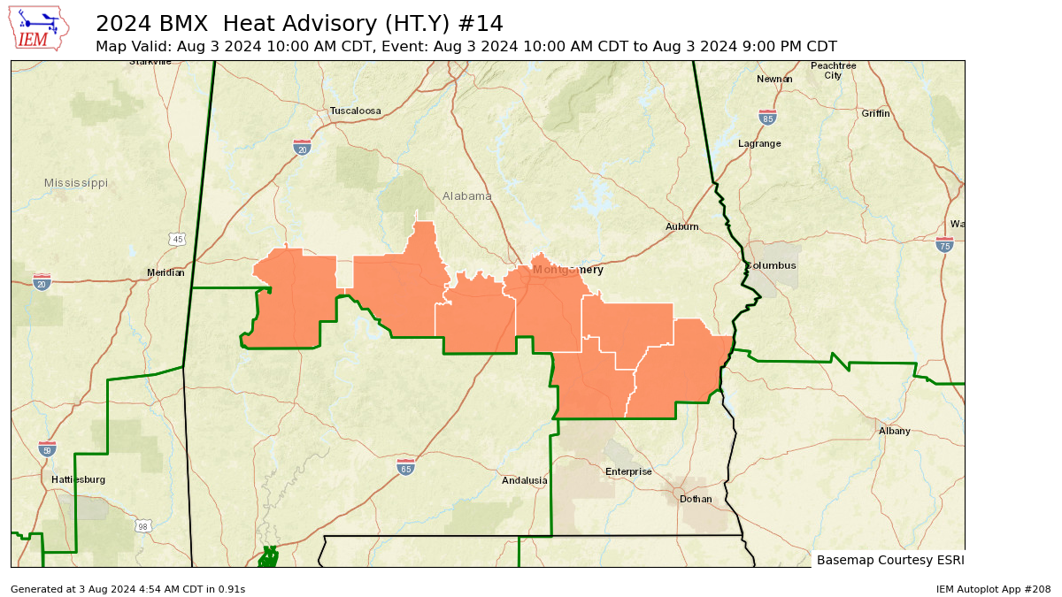
Heat Advisory in effect today for the far southern counties of Central Alabama.
While it will continue to be hot and humid today, it will be cooler than what we have seen over the past week. Skies will be sunny over the northwestern half of Central Alabama, while a few clouds will form with the heating of the day, and scattered showers and storms will be possible this afternoon over the southeastern half. Highs in the upper 80s to the mid 90s. Nearly the same story for Sunday as the northwestern half will stay dry with sunny skies, and the southeastern half will have some clouds with isolated to scattered showers and storms possible by afternoon. Highs in the lower to mid 90s.
We’ll be dry across Central Alabama on Monday, but the main focus will be on the tropical storm affecting the southeastern portions of Georgia and up into eastern South Carolina. No impacts from soon to be named Debby will be felt in our area. Highs in the lower to mid 90s. Heat starts to build on Tuesday and Central Alabama will be dry with mainly sunny skies. Highs in the mid to upper 90s. Some southwestern locations in the area may hit or be slightly over 100 degrees. The good news is that we’ll have lower humidity levels, so heat indices will be right around the actual temperatures.
The heat continues on Wednesday, along with the dry weather and lower humidity. We’ll be mainly sunny with highs ranging from the mid 90s to right around 100 degrees. On Thursday, we may actually see the development of a trough over the eastern half of the country that my lower our temperatures a little. However, skies will continue to be mainly sunny, and no rain is expected. Highs in the 90s. And at the end of the forecast period on Friday, there will be no big change from Thursday. Mainly sunny and hot with highs in the 90s.
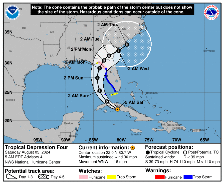
Tropical Depression #4 is currently over Cuba and is expected to become Tropical Storm Debby later today or tonight as it moves over the southeastern Gulf of Mexico. Tropical storm warnings and hurricane watches have been issued for much of the western coastline of the Florida Peninsula, with the current track showing a potential landfall on Monday morning between Apalachicola to Homosassa Springs. Tropical storm conditions are expected to start later today and continue through Sunday in the warned areas. Storm surge totals are expected to be in the 2-5 ft range. We could also see a spread of 5-15 in rainfall totals across portions of the southeast through Thursday morning. A few tornadoes are possible to the north and east of the center of circulation tonight through Sunday morning.
For now, the forecast keeps Debby below hurricane strength at her strongest point through the next 120 hours, but any slight change farther to the west in the forecast track would allow for strengthening, and a hurricane would become more likely.
Category: Alabama's Weather, ALL POSTS, Tropical, Weather Xtreme Videos
About the Author (Author Profile)
Scott Martin is an operational meteorologist, professional graphic artist, musician, husband, and father. Not only is Scott a member of the National Weather Association, but he is also the Central Alabama Chapter of the NWA president. Scott is also the co-founder of Racecast Weather, which provides forecasts for many racing series across the USA. He also supplies forecasts for the BassMaster Elite Series events including the BassMaster Classic.Subscribe
If you enjoyed this article, subscribe to receive more just like it.


