10pm CDT Tropical Update: We now have a tropical depression!
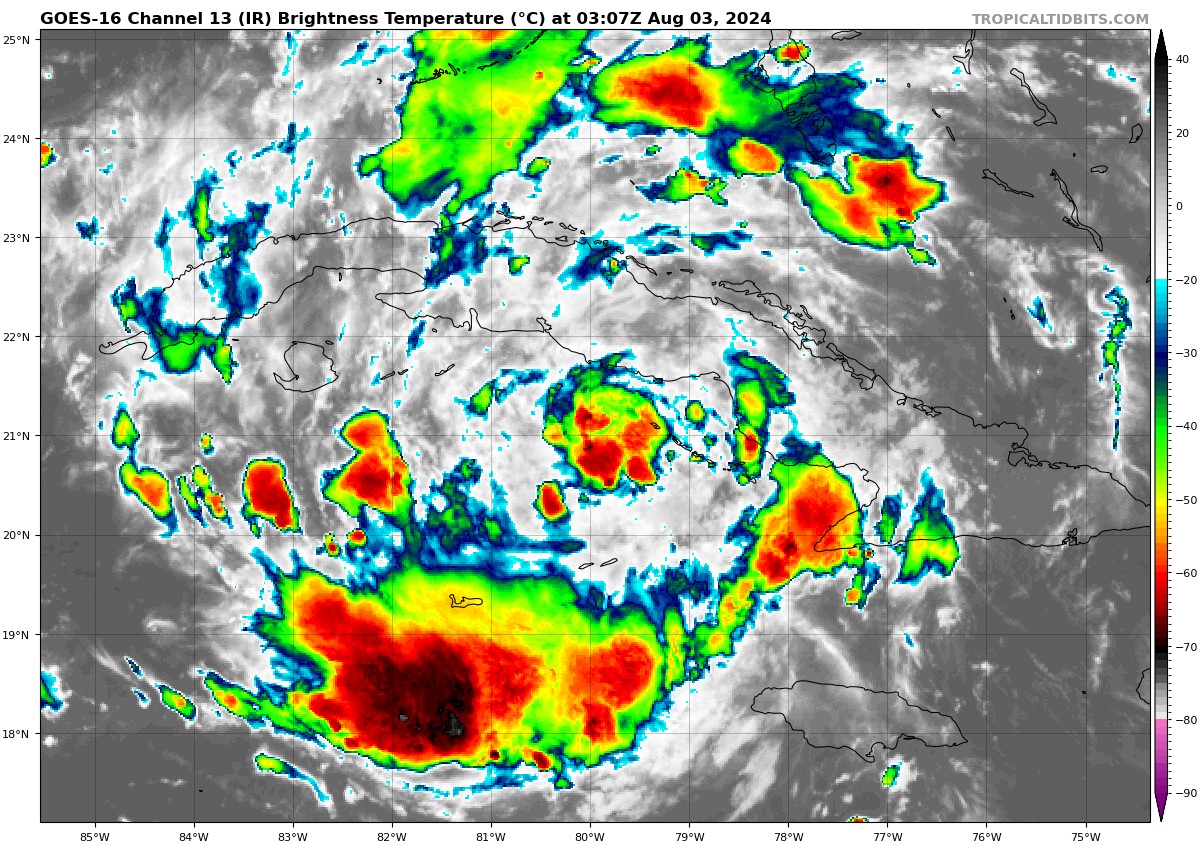
Infrared Satellite Image via Tropical Tidbits.
———————————————–
The 10pm CDT update from the National Hurricane Center has been issued and the disturbance we have been tracking has now become more defined and has developed a closed circulation. The system has organized enough to be deemed a tropical depression. Let’s dive into the latest update:
———————————————–
Public Advisory Information:
SUMMARY OF 1000 PM CDT…0200 UTC…INFORMATION
LOCATION…21.4N 79.7W
ABOUT 75 MI…125 KM S OF CAIBARIEN CUBA
ABOUT 260 MI…415 KM SSE OF KEY WEST FLORIDA
MAXIMUM SUSTAINED WINDS…30 MPH…45 KM/H
PRESENT MOVEMENT…WNW OR 285 DEGREES AT 17 MPH…28 KM/H
MINIMUM CENTRAL PRESSURE…1010 MB…29.83 INCHES
———————————————–
WATCHES AND WARNINGS: CHANGES WITH THIS ADVISORY:
A Tropical Storm Warning has been issued for the Dry Tortugas.
———————————————–
At 1100 PM EDT (0300 UTC), the center of Tropical Depression Four
was located near latitude 21.4 North, longitude 79.7 West. The
depression is moving toward the west-northwest near 17 mph (28
km/h). A turn toward the northwest is forecast on Saturday,
followed by a slower motion toward the north and then the northeast
on Sunday and Monday. On the forecast track, the center of the
depression will move across Cuba overnight and on Saturday, and then
move generally northward over the eastern Gulf of Mexico Saturday
and Sunday, potentially reaching the Florida Gulf coast late Sunday
or Monday.
Maximum sustained winds are near 30 mph (45 km/h) with higher gusts.
Strengthening is forecast during the next several days, and the
depression is expected to become a tropical storm on Saturday and
continue strengthening over the eastern Gulf of Mexico through the
weekend.
The estimated minimum central pressure is 1010 mb (29.83 inches).
———————————————–
Deep Dive Into The Discussion:
Per the NHC discussion there has been a slight shift to the west with the official track. Tropical depression 4 is still moving west-northwest at this hour. A turn toward the northwest and then north is expected over the weekend due to a break in the subtropical ridge caused by a trough over the eastern United States.
Since there has not been a turn northwest yet, the computer model guidance has shifted slightly more west with the track. The updated NHC forecast is a bit west of the previous forecast along the eastern edge of the main cluster of models.
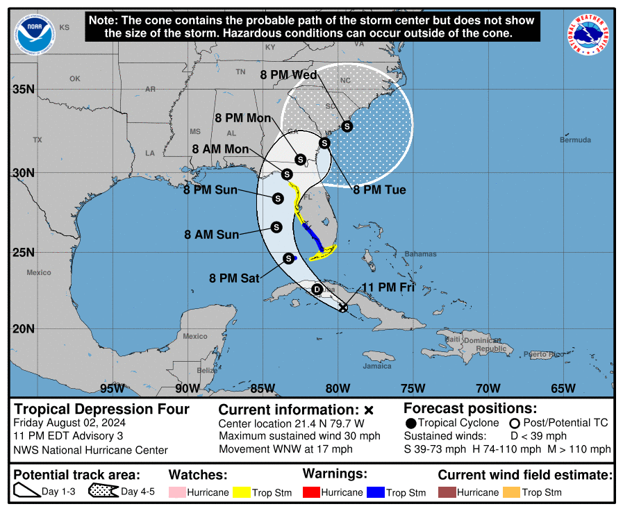
Notice in the track there is a still a turn into the Florida Big Bend area and then a slower crawl toward the southeast coast. From the discussion:
….the models seem to be showing the aforementioned trough leaving the cyclone behind early next week, which causes a much slower motion while the system is near the coasts of Georgia and South Carolina. As a result, the new NHC forecast is notably slower than the previous forecast, particularly on days 4 and 5.
Another note about the westward shift: This tropical system may stay over the warm waters of the Gulf longer, which gives it the potential to strengthen more. A good chunk of the guidance brings this system to hurricane strength before crossing into the Big Bend region.
A strengthening storm would mean bigger wind and surge impacts. And this will be a huge rain maker for portions of Florida and the southeast coast. As with all lanfalling systems, there is also a tornado risk. That risk will increase for the Florida Keys and western Florida Peninsula Saturday night into Sunday morning.
———————————————–
Alabama Impacts:
Even though there has been a slight shift to the west with the track, no impacts for most of the state. With an increased swell, there will be an increased rip current risk for the beaches of Alabama east to the Panhandle of Florida.
We of course will be monitoring this closely as this tropical depression makes it ways toward the state of Florida.
Category: Alabama's Weather, ALL POSTS, Tropical
About the Author (Author Profile)
Owner of Tornado Talk. Radio broadcast meteorologist with The Storm Report. WeatherBrains Panelist. B.S. Meteorology from Penn State University.Subscribe
If you enjoyed this article, subscribe to receive more just like it.


