430am CDT Update: Hurricane Debby Landfall Soon; Major Impacts For Portions of the Southeast This Week
Good Monday morning everyone! Very active start to the week with Category 1 Hurricane Debby close to landfall at this time. We will continue with frequent updates throughout the day to keep you informed on the latest.
The 4am CDT update is out and here is the summary:
SUMMARY OF 500 AM EDT…0900 UTC…INFORMATION
———————————————-
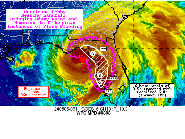
LOCATION…29.5N 83.7W
ABOUT 45 MI…75 KM NW OF CEDAR KEY FLORIDA
ABOUT 70 MI…115 KM SSE OF TALLAHASSEE FLORIDA
MAXIMUM SUSTAINED WINDS…80 MPH…130 KM/H
PRESENT MOVEMENT…NNE OR 15 DEGREES AT 10 MPH…17 KM/H
MINIMUM CENTRAL PRESSURE…979 MB…28.91 INCHES
No changes in watches and warnings. Full list here!
Debby is moving to the north-northeast around 12 mph and that slower movement is still forecast by late today and tonight. The eyewall is moving onshore and landfall will occur over the next few hours on the Florida Big Bend. Notice in the radar grab that the we still have deep convection moving in from Keaton Beach to Jena. It’s a wall of rain spreading north from the center encompassing a good chunk of north Florida. The WPC has issued a Mesoscale Precipitation Discussion. 6 hour rainfall totals of 3-5″ expected with locally higher amounts.
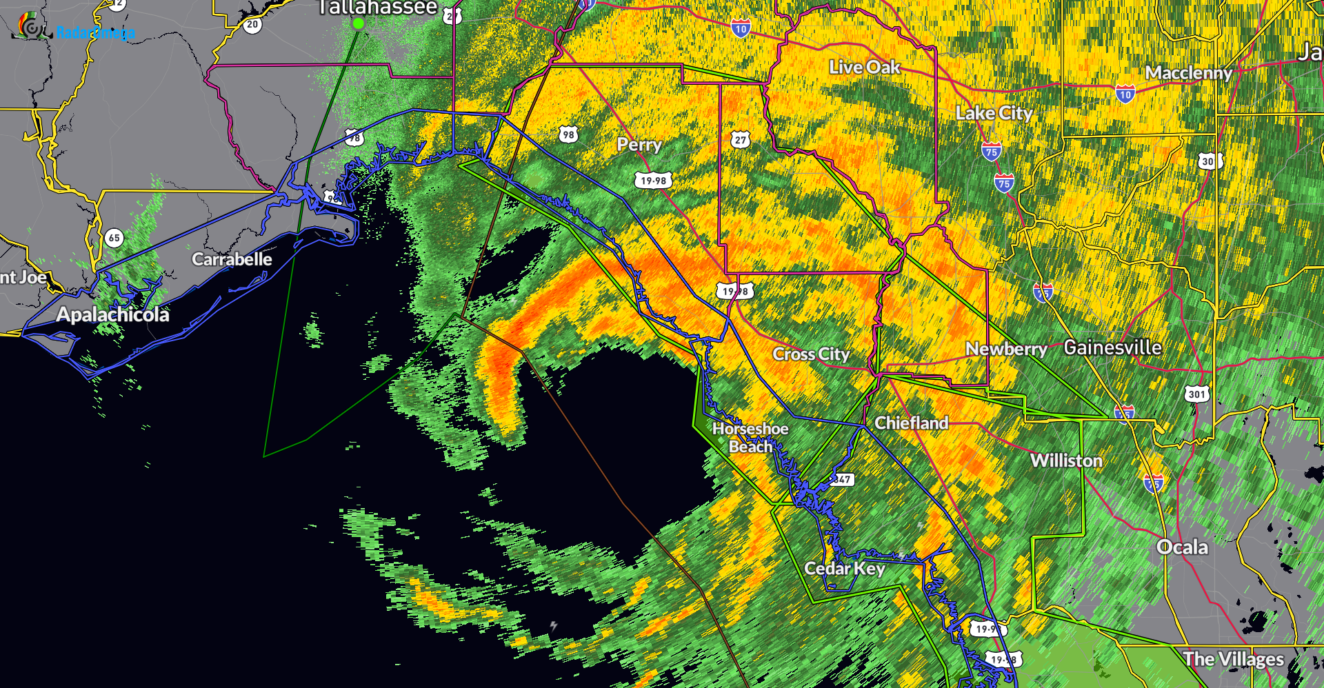
Sustained tropical storm force winds are being reported across the Big Bend. Horseshoe Beach and a sustained wind of 65 mph (gusts to 95 mph). Sustained winds greater than 60 mph reported as well near Steinhatchee. The hurricane hunters are still flying into Debby and report in that the storm has max winds at 70 kts. Little strengthening expected now before landfall.
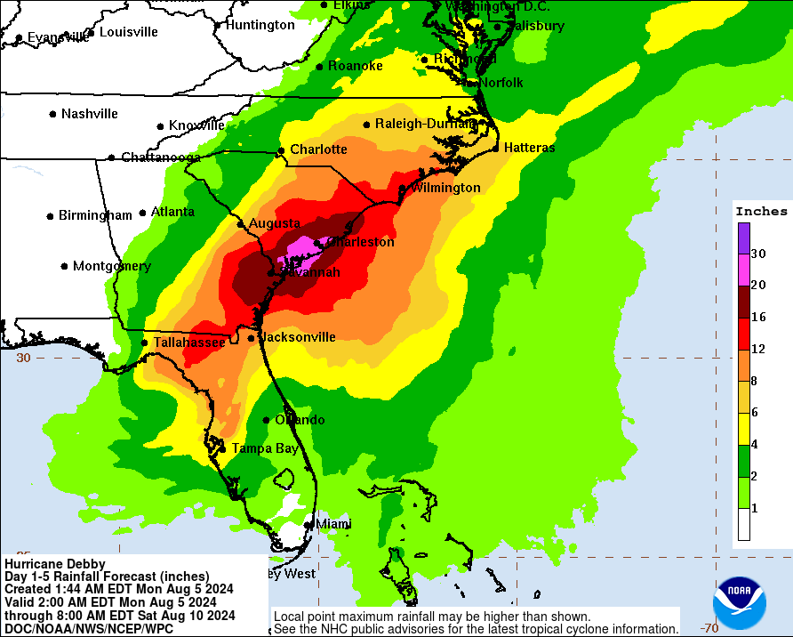
The wind at this time isn’t the main concern….it is the water. Catastrophic flooding is forecast for portions of the Florida, Georgia and South Carolina this week. Why? Debby is still expected to slow near the southeast coast. There is uncertainty on the track as the week goes on. The models bring Debby off the GA/SC coast by mid week and then back on shore before slowly moving north into central North Carolina by Friday night. Here is the official forecast cone from the NHC:
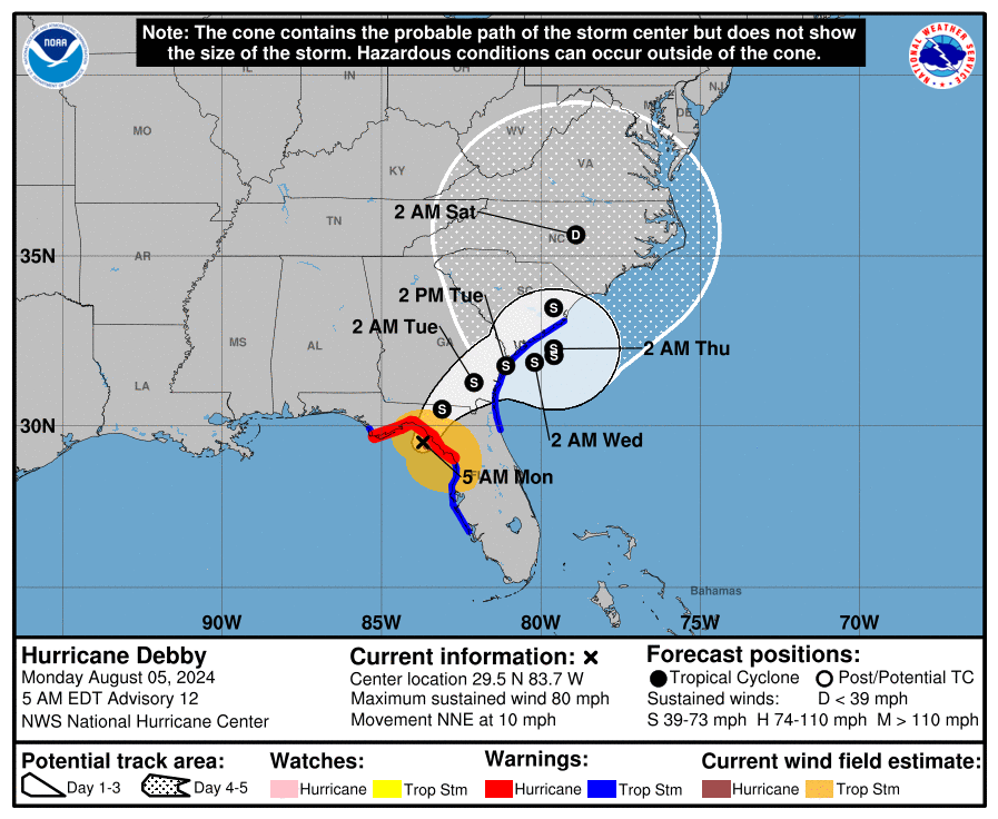
We can’t stress enough how concerning this is for our friends to the east. Over the next week, portions of southeast Georgia, the coastal plain of South Carolina, and southeast North Carolina could see 10-20 inches of rain, with locally up to 30 inches a possibility!
Coverage continues all day on the blog and on X. Follow us here!
About the Author (Author Profile)
Owner of Tornado Talk. Radio broadcast meteorologist with The Storm Report. WeatherBrains Panelist. B.S. Meteorology from Penn State University.Subscribe
If you enjoyed this article, subscribe to receive more just like it.


