Tropical Storm Debby Update – Late This Evening
CURRENT STATUS AND FORECAST
– Landfall and Current Location: Debby made landfall at 7 am EDT near Steinhatchee, Florida, as a Category 1 hurricane with winds of 80 mph. It has since weakened to a tropical storm with maximum sustained winds of 50 mph and is currently near the Florida/Georgia border.
– Track: Debby is moving through a weakness in the subtropical high and is now on a northeastward trajectory at 6 mph. It is expected to continue this path over southeastern Georgia before moving offshore near Brunswick and Savannah, Georgia, on Tuesday. The system will likely re-intensify as it moves over warm waters, potentially becoming a hurricane again. A second landfall is possible near Myrtle Beach, South Carolina, on Thursday with winds of 85-90 mph.
– Intensity: Debby is forecast to weaken while over land but could re-intensify once back over water. The National Hurricane Center predicts gradual strengthening, but it does not look like it will become a hurricane again. There is a lot of uncertainty there and anything could happen.
IMPACTS
1. Wind:
– Tropical Storm Force Winds: Expected along the Georgia and South Carolina coasts from Tuesday through Thursday, with the strongest winds likely on Thursday near Georgetown and Myrtle Beach.
2. Freshwater Flooding:
– Primary Concern: The flooding threat from Tropical Storm Debby is expected to be the most significant impact and will likely be what this storm is remembered for.
– Rainfall Totals: Storm totals in excess of 1 to 1.5 feet are expected, with heavy rainfall falling onto already saturated ground from a predecessor rain event (PRE) a few days ago. This combination significantly increases the flood risk.
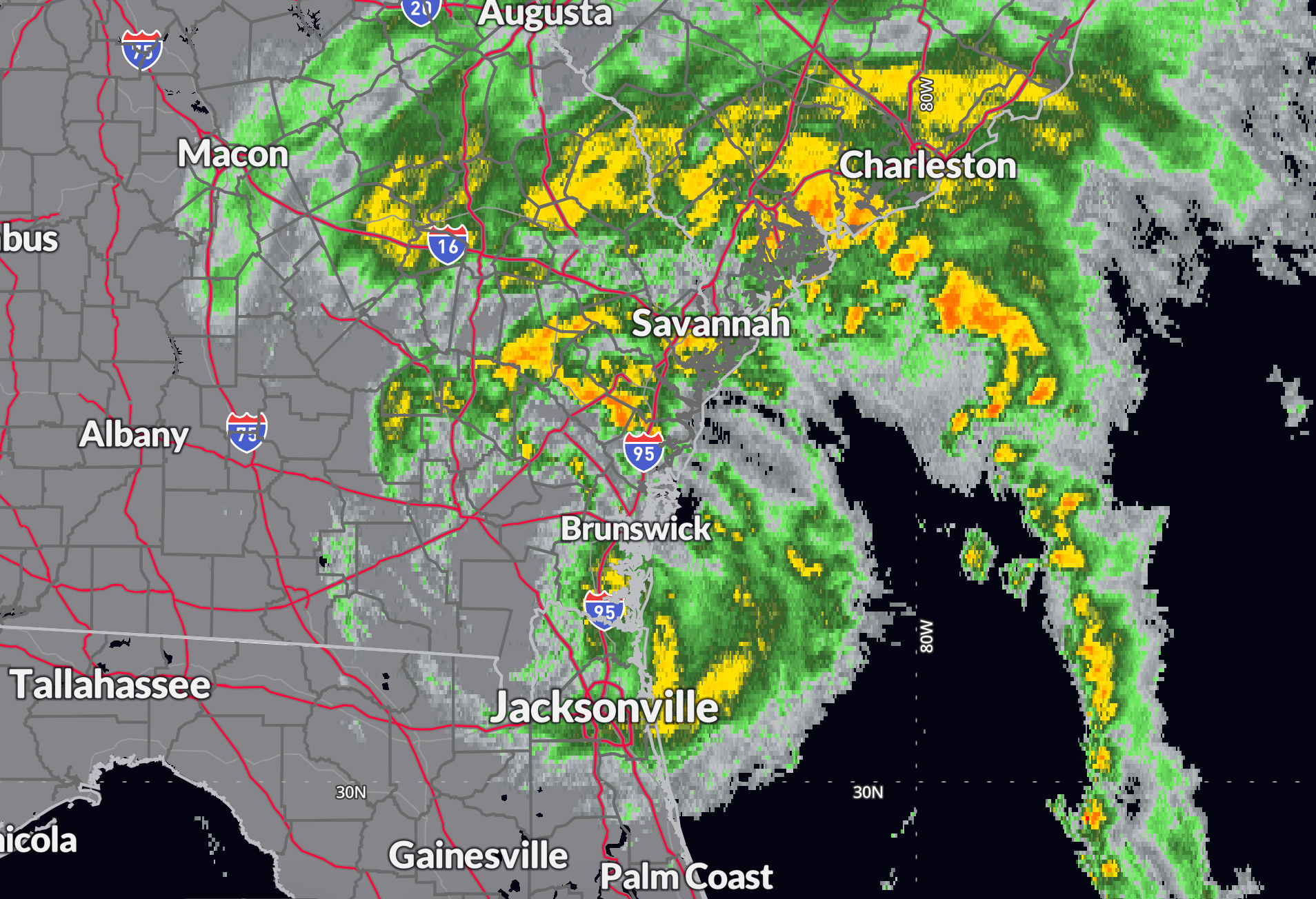
– Current Conditions and Forecast: According to the latest Mesoscale Precipitation Discussion, Debby is slowing down as it moves northeastward into southeast Georgia. Despite weakening, Debby is still capable of producing very heavy rainfall rates of 1.5 to 2.5 inches per hour, particularly along the immediate center. However, a corridor of low-level instability and convergent flow offshore is expected to enhance rainfall rates in eastern Georgia and the South Carolina Lowcountry. Rainfall rates within the stronger convective bands could reach 2 to 3 inches per hour, with localized heavier amounts due to mesocyclone activity. Additional rainfall totals of 3 to 6 inches are expected through midnight, with isolated heavier amounts possible, leading to life-threatening flash flooding and potentially catastrophic impacts on a localized basis.
– Southeastern Georgia & Southeastern South Carolina: Catastrophic flooding is possible, with 18 to 30 inches of rain and localized amounts over 3 feet. Major river flooding is expected, particularly in areas such as Savannah, Hilton Head, Charleston, Beaufort, and Myrtle Beach, continuing into the weekend.
– North Carolina: Central and eastern regions may see 5 to 10 inches of rain, with 12 to 18 inches in southeastern areas, leading to significant flooding risks.
– Mid-Atlantic & Southern New England: Heavy rainfall of 3 to 6 inches is likely, with potential for serious flooding late this week and into the weekend.
3. Storm Surge and Coastal Flooding:
– Georgia & South Carolina Coasts: A prolonged storm surge threat will persist through Wednesday and Thursday, with surge heights of 2 to 5 feet. This could result in moderate to significant coastal flooding, especially during high tide cycles.
4. Rip Currents:
– Dangerous rip currents are expected along the southeastern U.S. coast, particularly along the Georgia, South Carolina, and North Carolina coasts, as the storm moves offshore and strengthens.
5. Tornadoes:
– There is a potential for isolated tornadoes, especially in the areas affected by the storm’s rainbands. The risk will be highest in southeastern Georgia and South Carolina through Wednesday and Thursday.
ADDITIONAL DISTURBANCE IN THE CARIBBEAN
– Western Caribbean Sea and Southwestern Gulf of Mexico: A tropical wave over the eastern Caribbean Sea is producing disorganized showers and thunderstorms. Development of this system is expected to be slow over the next couple of days as it moves westward across the eastern and central Caribbean Sea. Environmental conditions are forecast to become more conducive for development later in the week, potentially leading to the formation of a tropical cyclone as the system moves across the western Caribbean Sea or the southern Gulf of Mexico.
– Formation chance through 48 hours: Low, 10 percent.
– Formation chance through 7 days: Low, 30 percent.
FORECAST FOR CHARLESTON
Based on current forecast track…Tropical Storm Debby is expected to bring strong wind gusts of up to 53 mph and a moderate storm surge to Charleston, SC. Northerly tropical storm force winds (39 mph) are anticipated to begin on Wednesday at 9 PM CDT, with the highest winds occurring around 11 AM CDT on Thursday, reaching sustained speeds of 44 mph from the northwest. Winds will decrease below tropical storm force by 3 PM CDT, with gusts above tropical storm force lingering for several more hours. While no significant wind damage is expected, heavy rainfall totaling approximately 20.7 inches over the next five days could lead to flooding. Additionally, there is a 74% chance of a storm surge reaching 3 feet above ground level.
FORECAST FOR SAVANNAH
Debby is expected to bring wind gusts of up to 48 mph to Savannah, GA. Easterly tropical storm force winds (39 mph) are anticipated to begin overnight at 3 AM CDT, with the highest winds occurring around 10 AM CDT, reaching sustained speeds of 40 mph from the east. Winds are expected to decrease below tropical storm force by 6 PM CDT, with gusts above tropical storm force lingering for several more hours. No significant wind damage is expected. The total rainfall forecast for the Savannah area over the next five days is approximately 12.1 inches, which could lead to localized flooding.
CONCLUSION
Residents in the affected areas should prepare for extreme weather conditions, including severe flooding, dangerous winds, storm surge, and possible tornadoes. The flooding threat, in particular, is expected to be the most significant and lasting impact of Tropical Storm Debby, with extreme rainfall on already saturated ground exacerbating the risk. Additionally, monitor the development of the disturbance in the Caribbean as it could develop further in the coming days. Follow local authorities’ instructions and stay informed of the latest updates as the situation evolves.
About the Author (Author Profile)
Bill Murray is the President of The Weather Factory. He is the site's official weather historian and a weekend forecaster. He also anchors the site's severe weather coverage. Bill Murray is the proud holder of National Weather Association Digital Seal #0001 @wxhistorianSubscribe
If you enjoyed this article, subscribe to receive more just like it.


