Sunday Morning Video Briefing: Dog Days Coming to an End
As we wrap up the second week of August, Central Alabama’s weather promises to deliver a blend of warm summer days and cool, comfortable mornings, setting the stage for a mostly dry and hot week ahead. With the Perseid meteor shower peaking this Sunday night, there’s plenty to look forward to in the skies. Let’s break down what to expect in the days ahead.
DOG DAYS COME TO AN END
Sunday, August 11th, marks the official end of the “Dog Days of Summer,” a period traditionally associated with the peak of summer heat and humidity. As this stretch comes to a close, we’re greeted with slightly cooler and drier air, signaling a subtle shift as we inch closer to the end of summer. While the days will remain warm, the drop in humidity will bring a much-welcome reprieve, especially in the mornings and evenings.
SYNOPTIC SETUP FOR SUNDAY
A large but flattened ridge extends across much of the southern half of the U.S., with a broad upper-level low centered over Ontario. This setup will support sunny and hot conditions across Central Alabama, though temperatures will be closer to normal due to a dry, northerly flow. Dew points will range from the 60s to lower 70s, making for seasonably pleasant conditions. Expect morning lows in the mid to upper 60s, with highs in the upper 80s to around 90°F.
PLEASANT WEATHER FOR SUNDAY
Sunday will feature comfortable conditions with plenty of sunshine. Expect highs to reach the upper 80s across much of Central Alabama, while the northern areas will enjoy slightly cooler temperatures in the mid-80s. Morning lows will dip into the mid-60s, offering a refreshing start to the day. The humidity will be lower than usual, making it feel much more pleasant for any outdoor activities. Clear skies during the evening will provide ideal conditions for viewing the Perseid meteor shower.
THE WEEK AHEAD: TYPICAL SUMMER PATTERN
As we move into the workweek, the dry air will gradually be replaced by more typical summer humidity. Monday and Tuesday will be mainly dry with highs in the low 90s. Morning lows will be in the upper 60s to around 70°F. By midweek, the pattern will shift, bringing back the familiar hot, humid conditions with scattered afternoon showers and thunderstorms. The northwesterly flow will set up by Tuesday, potentially leading to an active MCS (Mesoscale Convective System) pattern from Wednesday through Friday, increasing the likelihood of showers and storms. Temperatures will begin to rise, with the potential for reaching Heat Advisory criteria by the end of the week.
WEEKEND OUTLOOK: CLASSIC AUGUST WEATHER
Looking ahead to next weekend, the classic August heat returns in full force. Highs will climb into the mid-90s, with humidity making it feel even hotter. Rain chances will stay low, with just a few isolated afternoon thunderstorms possible, especially in the southeastern part of the state. It’s a weekend that will feel very much like the dog days of summer.
LOOKING AHEAD TO WEEK TWO
In the week two period, we expect the overall pattern of hot and mostly dry weather to persist. High pressure will likely remain in control, keeping temperatures above average and rain chances below average. We’ll continue to monitor for any potential shifts, especially as we approach the peak of hurricane season.
PERSEIDS AND AURORAS: A CELESTIAL DOUBLE FEATURE
As we prepare for the peak of the Perseid meteor shower this Sunday night into Monday morning, there’s an added bonus for sky watchers, particularly in northern latitudes. High solar activity over the past few days has propelled multiple coronal mass ejections (CMEs) toward Earth, including one launched by a strong X-class solar flare. The National Oceanic and Atmospheric Administration (NOAA) Space Weather Prediction Center has issued a geomagnetic storm watch, predicting impacts on August 11th and 12th. These CMEs could spark minor (G1) to strong (G3) geomagnetic storms, potentially creating opportunities to see and photograph mid-latitude auroras. While this won’t affect those of us in Alabama, those further north could witness both the dazzling Perseid meteor shower and stunning auroras, making for a truly spectacular celestial show this weekend.
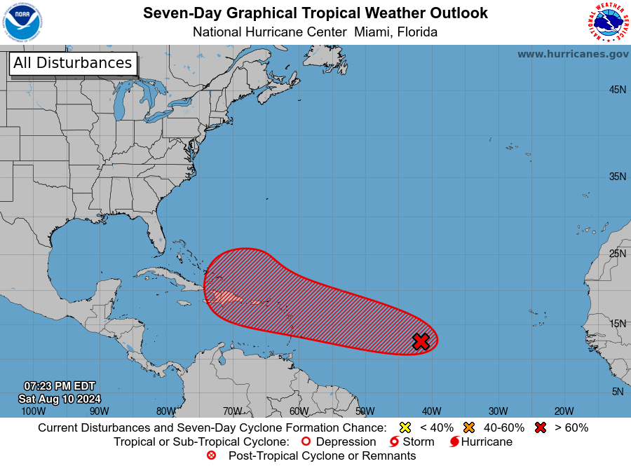
TROPICAL WEATHER WATCH
Invest 98-L, currently located about 1,300 miles east of the Lesser Antilles, is showing increasing signs of organization, with shower and thunderstorm activity becoming more concentrated. This system is expected to develop into Tropical Storm Ernesto by the time it reaches the northeastern Caribbean on Tuesday. Environmental conditions, though initially marginal, could become more conducive to development as the system nears 60°W longitude. If this happens, rapid intensification is possible as the system crosses the Leeward Islands, potentially bringing tropical storm conditions with winds of 50-70 mph to areas such as Guadeloupe, Antigua, and Barbuda by Tuesday. The system could further strengthen into a hurricane as it moves toward Puerto Rico and the Dominican Republic by Wednesday, with wind gusts of 65-90 mph and the risk of flooding and mudslides. Beyond this, the track remains uncertain, with potential influences from evolving weather patterns over the eastern U.S. and western North Atlantic. This could result in a range of outcomes, from a direct impact on the U.S. East Coast to a turn out into the open Atlantic, possibly threatening Bermuda. This is a developing situation that requires close monitoring in the coming days.
BEACH WEATHER UPDATE
If you’re planning a trip to the beaches along the Florida Panhandle from Pensacola to Panama City, expect classic summer conditions with highs in the mid-90s and heat indices frequently exceeding 100°F. The water temperatures are comfortably warm in the mid-80s, perfect for a dip to cool off. Surf heights will be around 1 foot, and while the risk of rip currents remains low, it’s always best to stay cautious, particularly near piers and jetties. Most days will be sunny with a slight chance of isolated afternoon thunderstorms, especially as we move into the latter half of the week.
WEATHERBRAINS UPDATE
In the latest episode of WeatherBrains, the team offered invaluable advice for aspiring meteorologists, focusing on the essential steps and challenges involved in pursuing a career in meteorology. The hosts shared personal experiences and guidance, making it a must-listen for anyone considering this path. Next week’s episode promises to be particularly intriguing as James Spann is set to host Dr. Jim Spann from NOAA’s Office of Space Weather Observation. Known for their shared name and the occasional mix-up on paper, this “Spann vs. Spann” episode will dive into the fascinating world of space weather while adding a touch of humor to the mix. Don’t miss it!
THIS DAY IN WEATHER HISTORY
…1860—The first of three significant hurricanes in 1860 struck the middle Gulf Coast, making landfall near the Mississippi-Alabama border. The storm caused severe flooding and loss of life in settlements along Lake Borgne, with storm surge flooding much of Water Street in Mobile, Alabama.
So, as we head into the new week, keep in mind that while the weather may not bring much excitement beyond the usual summer heat, the skies certainly will, with the Perseid meteor shower promising a spectacular display. Enjoy the pleasant conditions on Sunday and keep an eye out for those shooting stars!
Category: Alabama's Weather, ALL POSTS
About the Author (Author Profile)
Bill Murray is the President of The Weather Factory. He is the site's official weather historian and a weekend forecaster. He also anchors the site's severe weather coverage. Bill Murray is the proud holder of National Weather Association Digital Seal #0001 @wxhistorianSubscribe
If you enjoyed this article, subscribe to receive more just like it.


