Friday Afternoon Ernesto Update: Tropical Storm Force Winds Already Observed in Bermuda
Here is the latest update on Ernesto! We will be following the track of the hurricane through the weekend and documenting the impacts in Bermuda. A great follow in X is our friend Mark Sudduth with HurricaneTrack! Here is in Bermuda and is providing continuous updates!
Ernesto showing its strength now in Bermuda. This from John Smith’s Bay.@foxweather pic.twitter.com/V4sVxoOZmE
— Mark Sudduth (@hurricanetrack) August 16, 2024
———-
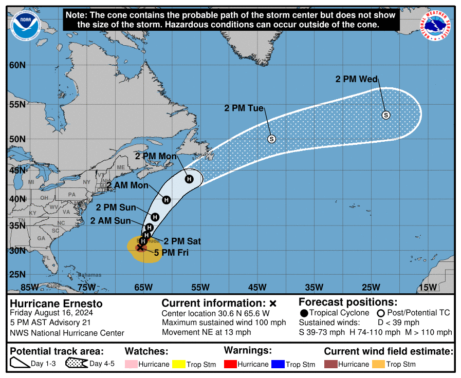
5pm AST Stats
LOCATION…30.6N 65.6W
ABOUT 125 MI…205 KM SSW OF BERMUDA
MAXIMUM SUSTAINED WINDS…100 MPH…155 KM/H
PRESENT MOVEMENT…NE OR 35 DEGREES AT 13 MPH…20 KM/H
MINIMUM CENTRAL PRESSURE…969 MB…28.62 INCHES
———-
No major changes in the with the thinking on where Ernesto is going. A pass near or over Bermuda is anticipated Saturday morning. Strength has not changed. Max sustained winds at the center of 100 mph. The hurricane wind extend 75 miles from the center and the tropical storm force winds reach up to 275 miles from the center. The Bermuda International Airport has reported already, sustained winds of 41 mph and a gust to 63 mph. That is just the start of it.
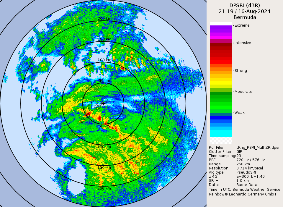
Ernesto has had a better look to it this afternoon. Per the NHC discussion, the hurricane hunters have denoted the eyewall structure has improved. You can see the eyewall in the radar snapshot below.
Here is the 250 KM Surface Rainfall Intensity Radar from the Bermuda Weather Office as of 519 AST. Hefty rain bands are already encompassing Bermuda and the rain will mount up over the next 24 to 36 hours. 6-12 inches locally more still forecast. Dangerous surge and destructive waves will come in as well.
Per Brian McNoldy, Senior Research Associate at the Univ. of Miami Rosenstiel School, the last time Bermuda was hit by a Cat 2 hurricane was in September 2020. The name of the storm was Paulette.
Here are a few more views of what it looks like in Bermuda this Friday afternoon:
#HurricaneErnesto already pounding #Bermuda with big waves. Tropical storm forced winds and power outages have already started. @jpetramala @JordanHallWX anHallWX pic.twitter.com/JLYpYYJsIe
— WxChasing- Brandon Clement (@bclemms) August 16, 2024
In a dry slot between rainbands, but winds are starting to crank. Hotel vibrating from the gusts. Hurricane’s core is still many hours away. #Hurricane #ERNESTO in #Bermuda pic.twitter.com/4hQgOzAPAu
— Josh Morgerman (@iCyclone) August 16, 2024
High surf and rip current risk remains the big hazard of the east coast of the US.
About the Author (Author Profile)
Owner of Tornado Talk. Radio broadcast meteorologist with The Storm Report. WeatherBrains Panelist. B.S. Meteorology from Penn State University.Subscribe
If you enjoyed this article, subscribe to receive more just like it.


