Saturday Weather Briefing Video: Severe Weather Possible Today and Tomorrow
The week ahead brings a mix of weather events, from strong storms and oppressive heat to cooler, drier conditions as a cold front moves through. We’ll also keep an eye on Hurricane Ernesto as it impacts Bermuda today, while stargazers should prepare for a rare Supermoon Blue Moon on Monday night.
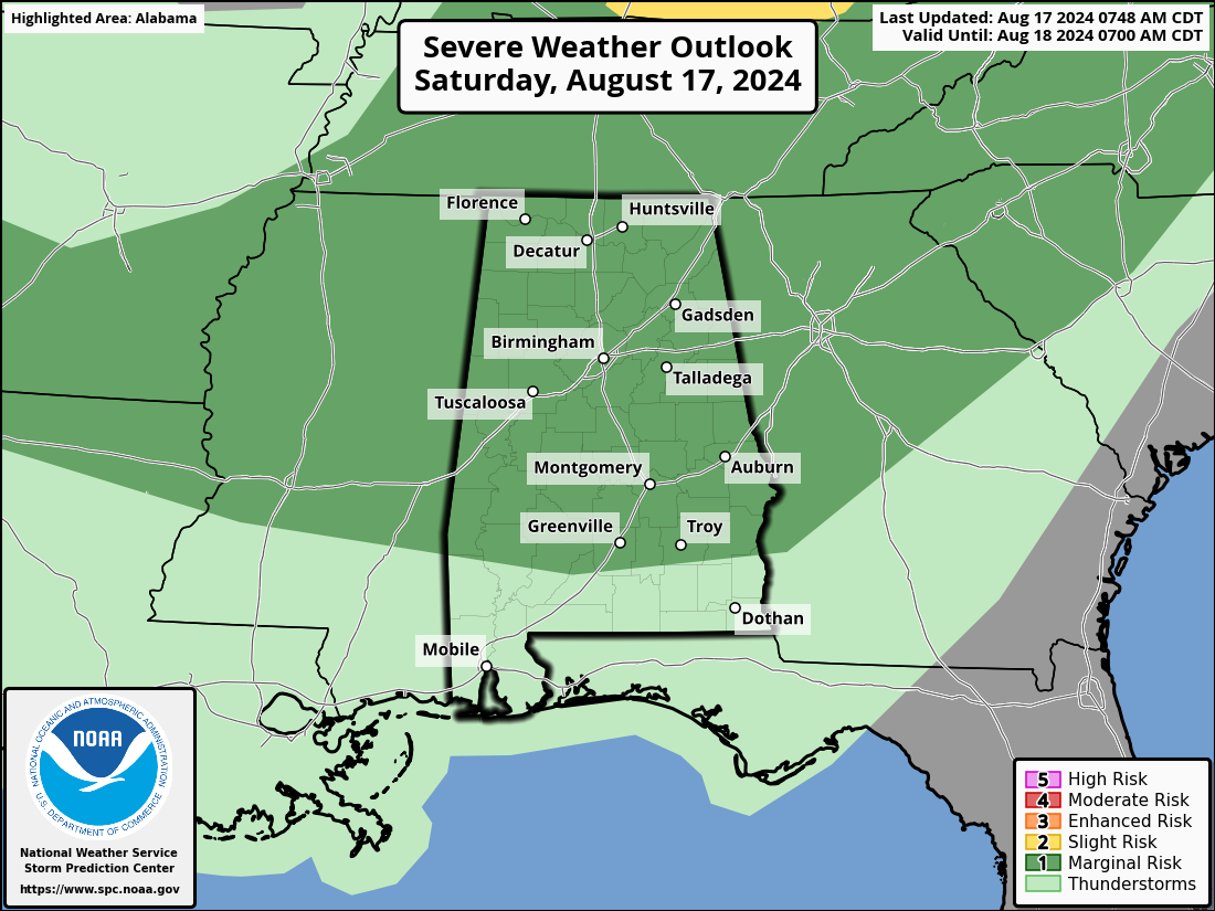
SEVERE WEATHER UPDATE: POTENTIAL FOR STRONG STORMS THIS WEEKEND
Showers and thunderstorms are expected across North and Central Alabama this weekend, especially during the afternoon and early evening hours. Some of these storms could become strong to severe, with the primary threats being damaging wind gusts, hail, and locally heavy rainfall.
Today, the northern areas are most likely to see storm development between 3 PM and 11 PM, with heat index values potentially exceeding 105 degrees before the storms arrive. On Sunday, the risk of severe storms extends across a broader area of Central Alabama, where more widespread storm coverage is expected along a frontal boundary. Damaging winds and quarter-sized hail are possible during this time.
Residents across North and Central Alabama should stay alert to changing weather conditions this weekend, particularly during the late afternoon and evening hours when storms are most likely to occur.
SATURDAY STORMS: STRONG WINDS POSSIBLE
Thunderstorms will develop late morning into the afternoon, with the strongest activity expected from the northern parts of the area down towards Clanton and Alex City. Expect mostly sunny skies in the morning, with a 60% chance of showers and thunderstorms in the afternoon. It will be humid, with highs in the mid-90s, and heat index values could reach up to 110°F.
OUTLOOK SUNDAY-MONDAY: STORMS THEN A BREAK
Sunday could see more storms, especially in the afternoon, as another shortwave moves through. By Monday, cooler and drier air will filter in, bringing a break from the oppressive heat. Highs will only reach the mid to upper 80s, and the humidity will drop noticeably, with a 40% chance of showers and thunderstorms on Sunday.
MID-WEEK TRANQUILITY: SUNSHINE AND COOLER NIGHTS
Tuesday through Thursday looks pleasant, with high pressure bringing mostly sunny skies and comfortable temperatures. Expect highs in the mid-80s and overnight lows in the upper 50s to low 60s, a welcome respite from the summer heat.
LATE WEEK CHANGES: MOISTURE RETURNS
By Friday, moisture will start to creep back into the region, leading to increasing clouds and a slight chance of showers. Highs will remain in the mid to upper 80s.
EARLY WEEKEND PEEK: UNSETTLED WEATHER AHEAD
Next weekend could see another round of storms as a new system approaches. Early indications suggest Saturday could be wet, so keep an eye on the forecast as we get closer.
WEEK TWO GLANCE: SEASONABLE WITH LOWER RAIN CHANCES
The following week looks seasonable with a mix of sun and clouds. Rain chances will be lower, and temperatures should hover around normal for this time of year.
BEACH PLANS? MOSTLY SUNNY WITH A CHANCE OF STORMS
For those heading to the Alabama and Northwest Florida beaches on Saturday, expect mostly sunny skies with a slight chance of afternoon thunderstorms. Surf heights will be around 2 feet, and the water temperature is in the upper 80s, perfect for a swim. The rip current risk remains low, but it’s always best to swim near lifeguards, especially near jetties and piers. Winds will be light from the south at 5 to 10 mph. With a high UV index, make sure to apply plenty of sunscreen. Looking ahead, Sunday will bring similar conditions with a chance of afternoon storms and low rip current risks. Early next week, surf heights will decrease slightly to 1 to 2 feet, with continued low rip current risks and sunny skies expected.
EYES ON THE TROPICS: ERNESTO IMPACTING BERMUDA
As of 7 a.m. Saturday morning, Hurricane Ernesto is currently battering Bermuda, with the island now experiencing the full force of the southern eyewall. After making landfall earlier this morning, Ernesto has brought extreme winds, torrential rain, and life-threatening conditions to the archipelago. Winds within the southern eyewall are expected to be sustained at 90 mph, with gusts exceeding 110 mph, causing widespread damage. The eye of the storm is passing directly over or very close to Bermuda, bringing a brief period of calm before the northern eyewall moves in with another round of intense winds and rain.
Bermuda is facing hurricane-force winds, heavy rainfall leading to flash flooding, and a dangerous storm surge that could inundate coastal areas. Power outages and structural damage are likely widespread across the island. Ernesto’s slow movement means that these hazardous conditions will persist through much of the morning before the storm begins to pull away later today.
As Ernesto moves northeastward away from Bermuda this afternoon, the focus will shift to the U.S. East Coast, the Bahamas, and Atlantic Canada, where swells generated by the hurricane will create dangerous surf and rip currents through the weekend. Cleanup and recovery efforts will begin in Bermuda once the storm has fully passed, but residents are urged to remain sheltered until local authorities declare it safe to emerge.
MOON MAGIC: SUPERMOON BLUE MOON MONDAY NIGHT
Mark your calendars for a rare celestial event on Monday night: a Supermoon Blue Moon. The moon will rise at 7:47 PM CDT in Central Alabama, offering a spectacular view. This phenomenon occurs when a full moon is both a supermoon, appearing 30% brighter and 14% larger than usual, and a Blue Moon, the third full moon in a season with four. Though it won’t actually be blue, the moon will be a stunning sight, especially as it rises near the horizon. Get your cameras ready for a beautiful display in the night sky.
WEATHERBRAINS RECAP: SPACE WEATHER WITH DR. JAMES SPANN
In the latest episode of WeatherBrains, the team welcomed Dr. James Spann, a Senior Scientist from NOAA’s Space Weather Center, to discuss the fascinating world of space weather. Dr. Spann shared his extensive experience from NASA to NOAA, delving into topics such as the increasing solar activity, the challenges of forecasting space weather, and the impact of solar events on Earth’s technology and communication systems. The episode also explored the differences in policy development between NASA and NOAA and highlighted the importance of partnerships in advancing space weather observations. The conversation provided deep insights into how space weather affects our daily lives, making it a must-listen for weather enthusiasts and professionals alike.
THIS DAY IN HISTORY: HURRICANE CAMILLE’S DESTRUCTIVE PATH
On August 17, 1969, Hurricane Camille was moving through the Gulf of Mexico, 250 miles south of the Alabama coast. Originally expected to hit the Florida Panhandle, Camille shifted west, prompting emergency warnings along the Gulf Coast. An Air Force reconnaissance flight recorded a record-low barometric pressure of 901 mb and winds of 190 mph, signaling catastrophic destruction ahead. When Camille made landfall in Pass Christian, Mississippi, with 200 mph winds and a 27-foot storm surge, 143 people perished along the coast, with another 113 dying in the Appalachian Mountains due to flash floods. Camille caused over $1 billion in damages and was later described as “the greatest storm of any kind ever to have affected the mainland of the United States.”
Category: Alabama's Weather, ALL POSTS, Severe Weather, Tropical
About the Author (Author Profile)
Bill Murray is the President of The Weather Factory. He is the site's official weather historian and a weekend forecaster. He also anchors the site's severe weather coverage. Bill Murray is the proud holder of National Weather Association Digital Seal #0001 @wxhistorianSubscribe
If you enjoyed this article, subscribe to receive more just like it.


