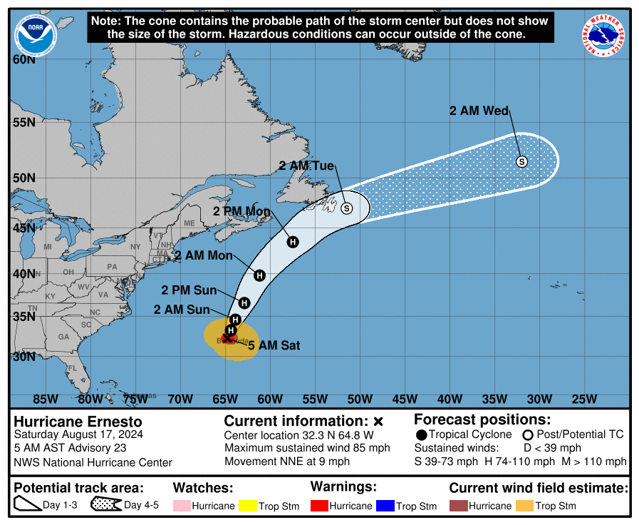
Saturday AM Ernesto Update: Made Landfall on Western Side of Bermuda
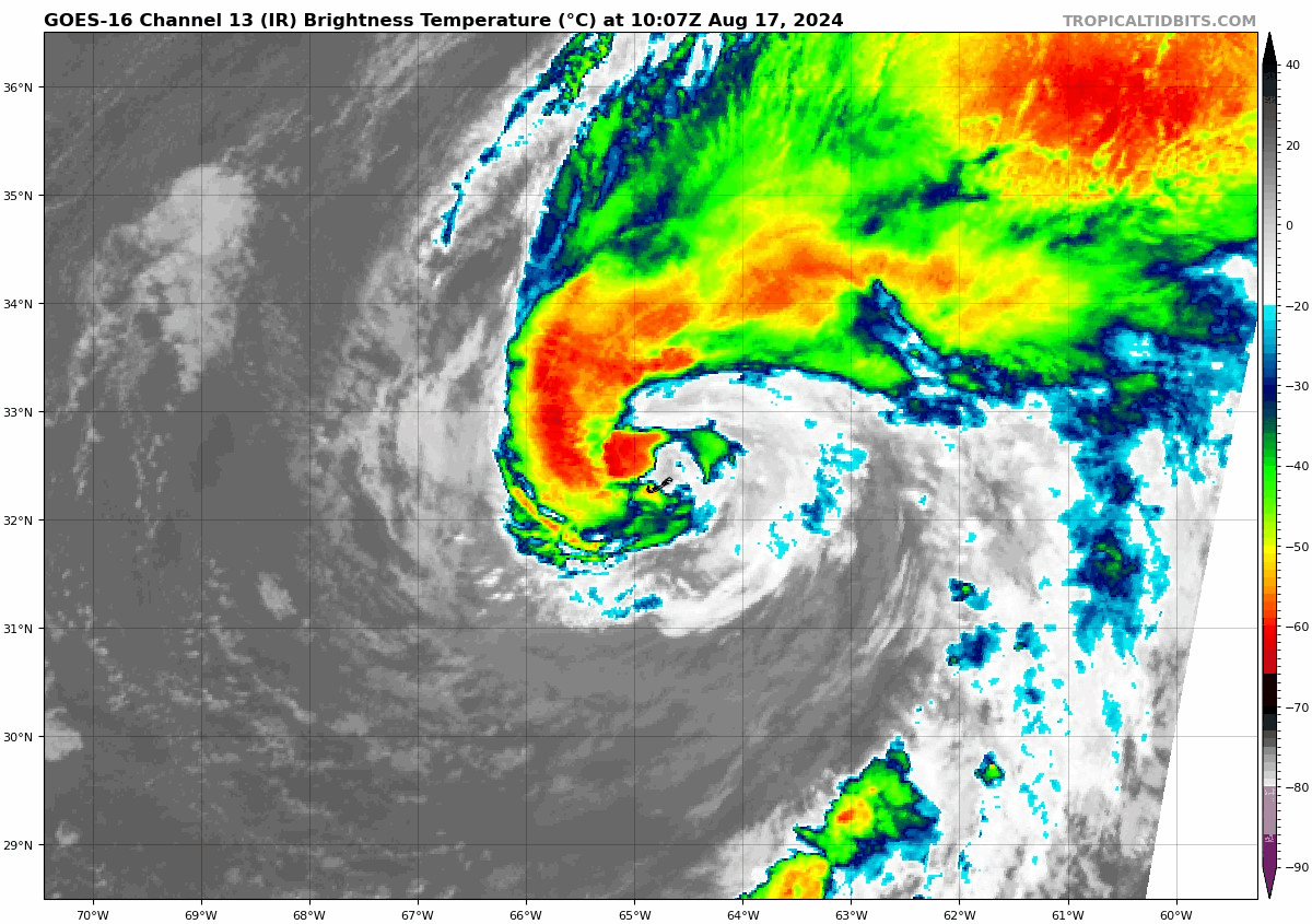
Good morning! Up and at ’em, looking at the latest on what Ernesto has been doing through the overnight hours and this morning. Per the NHC, this Category 1 hurricane made landfall at around 430am AST on the western side of Bermuda. Max winds were 85 mph and the pressure was 972 mb.
Dark but here is the eye of hurricane Ernesto as it moves over western Bermuda. Hint of a breeze, frogs and drizzle. Pressure steady at 972 mb. @foxweather pic.twitter.com/tgAuKwzm25
— Mark Sudduth (@hurricanetrack) August 17, 2024
A very ragged #HurricaneErnesto has made it ashore in #Bermuda @bclemms pic.twitter.com/2eltBYstkF
— Jonathan Petramala (@jpetramala) August 17, 2024
———-
Ernesto is moving to the north-northeast around 9 mph and this motion is expected today. A trough will pick up the ragged storm and move it more quickly to the northeast tomorrow and into early next. By Monday night, Ernesto will be near Newfoundland.
Much drier air has caused the system to become less organized, still big impacts have been felt across Bermuda. Will have a set of posts highlighting that.
Not a good deal of strengthening is forecast as Ernesto moves away from Bermuda. The water is plenty warm but the storm will be moving into a highly sheared environment on Monday, so any re-strengthening would be minimal. Ernesto is expected to become extratropical Monday night into Tuesday.
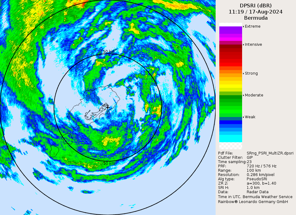
Most of Bermuda is without power this morning. High winds and heavy rain will persist for a few more hours. Here is the latest radar as of 719 AST. Southern part of the storm still needs to work through.
Some scenes of the impacts of Ernesto:
Great video of the waves from #Ernesto. Taken from @saildrone. @WKRG pic.twitter.com/z4crGhdYDd
— Ed Bloodsworth (@WKRGEd) August 17, 2024
Put a GoPro out to remote capture the waves coming in last night at a local resort. Those roll up doors didn’t stand a chance. #ernesto #Bermuda @foxweather pic.twitter.com/JlFTFrVFIQ
— Mark Sudduth (@hurricanetrack) August 17, 2024
Just after midnight in Paget Parish #Bermuda. Winds is starting to crank. #Hurricane #ERNESTO pic.twitter.com/6teBPNKpyP
— Josh Morgerman (@iCyclone) August 17, 2024
About the Author (Author Profile)
Owner of Tornado Talk. Radio broadcast meteorologist with The Storm Report. WeatherBrains Panelist. B.S. Meteorology from Penn State University.Subscribe
If you enjoyed this article, subscribe to receive more just like it.


