A Few Late Morning Notes on Ernesto
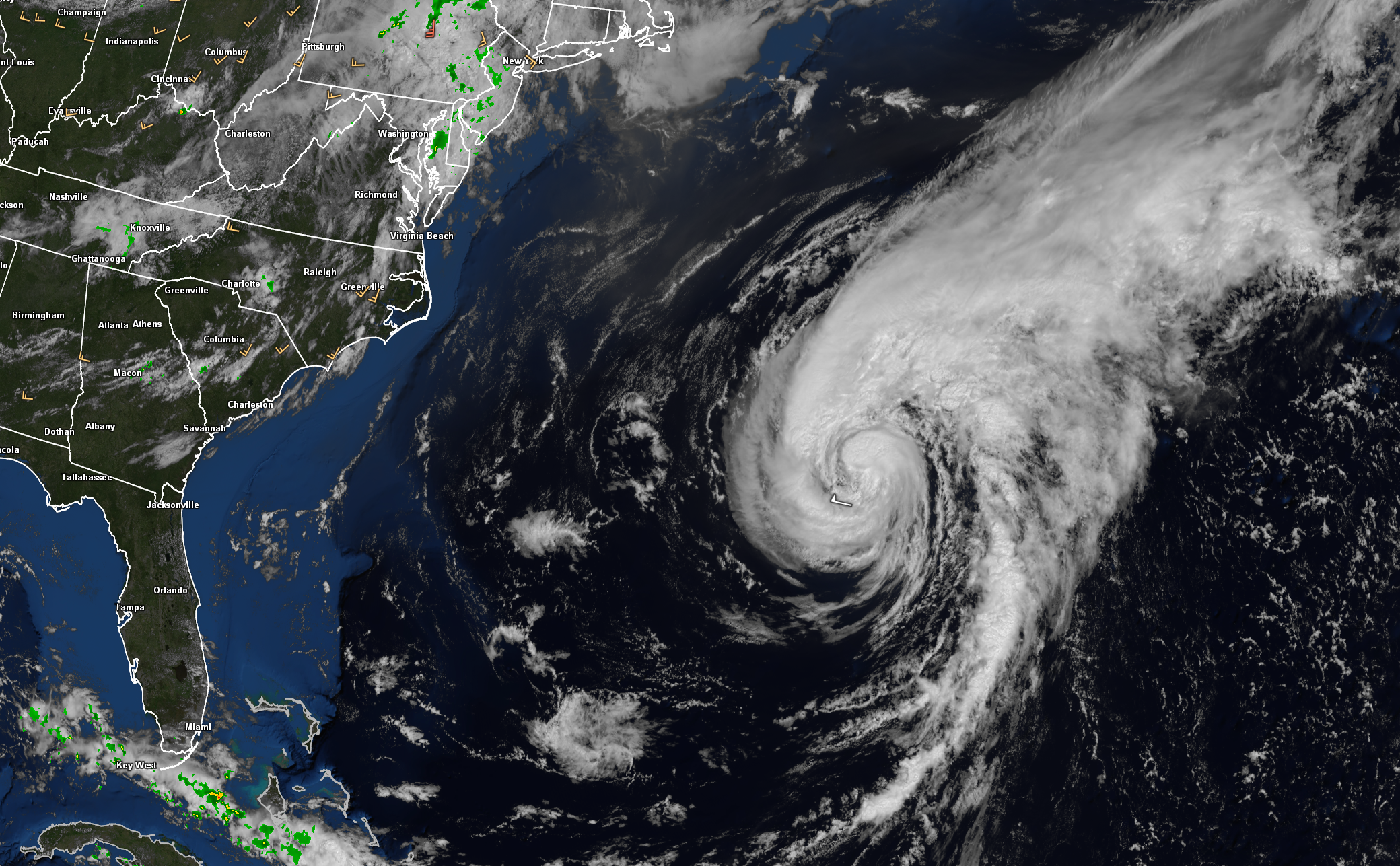
Hurricane Ernesto made landfall at 430 a.m. AST in Southhampton Parish, Bermuda with a central pressure of 972 mb and 85 mph. The last storm to make landfall in Southhampton was Gonzalo in 2014. The last storm to directly impact Bermuda was Paulette in 2020. It was a category 1 hurricane with 90 mph winds.
The actual central pressure on the island may have been 970 millibars. L.F. Wade International Airport recorded 969.98 at 8:07 a.m. AST. That would tie Ernesto with the 1922 hurricane and Gonzalo in 2014 as the lowest pressures measured during landfall on the island. Data was lost at L.F. Wade durign the peak of the storm during Fabian.
Hurricane Man, Josh Morgerman reported a “dirt” eye, with lots of “junk” in it. Winds at L.F. Wade calmed down after 5 a.m., but continued to average of 8-22 mph until the southern eyewall moved back over the station after 9 a.m. Since then, winds have gusted as high as 48 mph. Winds gusted to 84 mph at 1:55 a.m. AST.
Dry are definitely worked into the western and southern half of the circulation, drying up any precipitation on that side of the storm.
Tropical storm force wind gusts will continue to impact Bermuda through this evening.
By 5am, 70% of the archipelago was without power. The National Museum of bermuda was reporting wind gusts to 103 mph as the archipelago was in the northern eyewall. Their peak wind gust was 109 mph.
Large swells are reaching the beaches of the United States East Coast. A couple of beach houses fell into the ocean at Rodanthe on the North Carolina Outer Banks.
At a NOAA Buoy 150 miles east of Hatteras, the wave height has been as high as 12 feet. The wave period is running 12 seconds, much longer than on a normal day.
On a normal day at the beach, the wave period—the time it takes for successive waves to pass a fixed point—is typically between 6 and 12 seconds. This period is generally associated with smaller, more consistent waves that are influenced by local winds and relatively calm ocean conditions. These waves are gentle, making for ideal conditions for swimming, wading, and other beach activities.
When there’s a hurricane offshore, the wave period can increase significantly, often reaching 15 to 20 seconds or more. This is due to the powerful winds and large-scale oceanic disturbances generated by the hurricane, which can create long-period swells that travel great distances. These swells are much larger, more powerful, and spaced farther apart compared to normal conditions. The longer wave period and increased wave height during a hurricane can lead to dangerous rip currents and strong undertows, making the ocean much more hazardous even if the storm is still far away. Beachgoers should exercise extreme caution and heed local warnings when a hurricane is in the vicinity.
Ernesto may strengthen a bit today over relatively warm water as shear relaxes.
Nova Scotia will not see significant impacts unless you live on Sable Island. Sable Island will experience some wild impacts, but less than 25 people live on the island. It is basically a sandbar 190 miles southeast of Halifax. Nova Scoita.
All of the recent model runs keep the center just offshore of Cape Race, Newfoundland, keeping the land areas of the Avalon Peninsula on the weaker western side of circulation, which will limit wind damage. The fast forward motion will limit flooding potential.
About the Author (Author Profile)
Bill Murray is the President of The Weather Factory. He is the site's official weather historian and a weekend forecaster. He also anchors the site's severe weather coverage. Bill Murray is the proud holder of National Weather Association Digital Seal #0001 @wxhistorianSubscribe
If you enjoyed this article, subscribe to receive more just like it.


