The Alabama Weather Summary at Noon: Heat Indices at or near 105; Heat Advisories in Effect
Heat index values
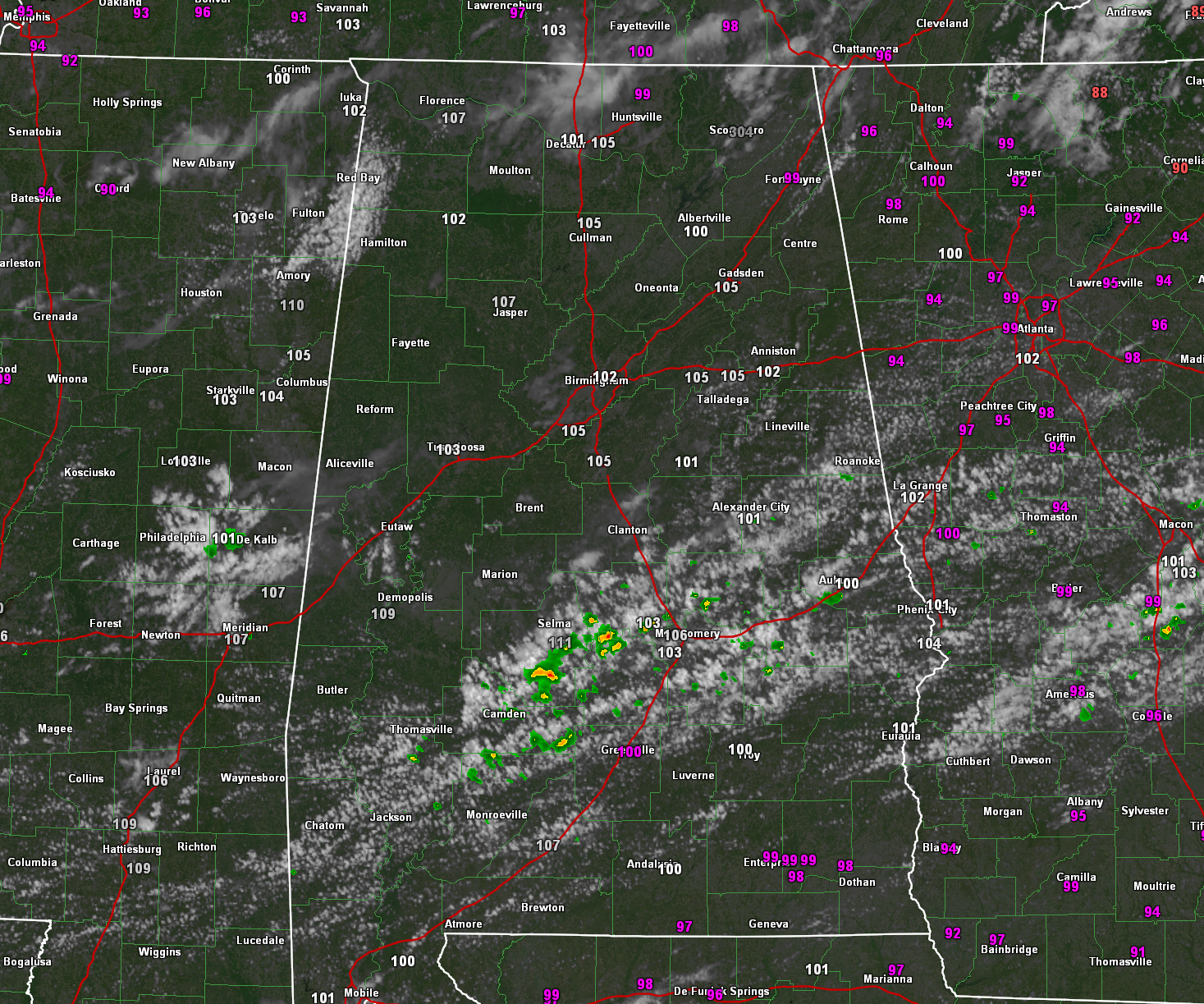
Skies are mostly sunny across the northern half of Alabama late this morning, with partly cloudy skies. An outflow boundar that pushed throguh the area this morning is producing partly sunny to mostly cloudy skies over South Central Alabama. A few showers are forming in the convergence and instability available in this area.
Temperatures this hour range from 88 at Auburn to 98 at Florence. It is 92 at Birmngham, 90 at Tuscaloosa and Anniston.
Heat index values are now hitting 105 at Pell City and Talladega, as well as Calera and Bessemer. Gadsden, Cullman, and Huntsville are at 105. Florence is at 107.
Just before noon, showers were developing from Wilcox and Dallas counties through Lowndes and Autauga counties up I-85 to Lee County where heavier showers were near Auburn. A few showers were in southeast Chilton County. Some lightning will be showing up shortly in Dallas County, as well as over in Lee county.
Another rounds of convection should fire around 3 p.m. near I-20, pushing south through the afternoon.
We will be watching all activity through teh afternoon for the threat of daamging winds.
NWS offices around the state maintain heat advisories for much of the state this afternoon as heat index values approach 106F in localized areas. The NWS in Mobile has issued a rare Excessive Heat Warning for Baldwin Central AL, Baldwin Coastal AL, Baldwin Inland AL, and Choctaw AL. Heat index value swill approach 114F in spots!
Take it easy if you are hanging out, playing, or working outside this afternoon.
The same will be true for Sunday afternoon, especially for areas across Central Alabama. The cold front should move through the Tennessee Valley during teh day on Sunday and into South Alabama by Monday morning. The front will make it well into the northern Gulf and a pretty fair piece down the Florida Peninsula by Tuesday.
We will have to watch this dying front over the Gulf for potential tropical development. None of the models are picking up on this, but that is always a possibility with a frontal system out over the Gulf this time of year.
Category: Alabama's Weather, ALL POSTS, Severe Weather
About the Author (Author Profile)
Bill Murray is the President of The Weather Factory. He is the site's official weather historian and a weekend forecaster. He also anchors the site's severe weather coverage. Bill Murray is the proud holder of National Weather Association Digital Seal #0001 @wxhistorianSubscribe
If you enjoyed this article, subscribe to receive more just like it.


