10 pm Update on Now Tropical Storm Francine
Tropical Storm Francine Advisory Number 14
NWS National Hurricane Center Miami FL AL062024
10:00 PM CDT Wed Sep 11 2024
Heavy Rains And Wind Gusts To Hurricane-Force Occurring In Metropolitan New Orleans
Summary Of 10:00 PM CDT Information
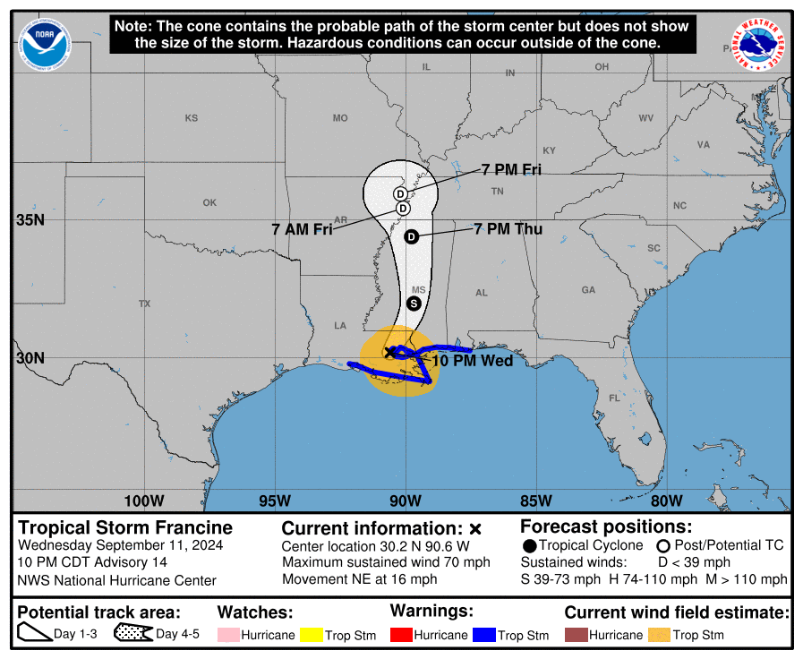
- Location: 30.2N 90.6W
- About: 35 mi (55 km) WNW of New Orleans, Louisiana
- Maximum Sustained Winds: 70 mph (110 km/h)
- Present Movement: NE or 45 degrees at 16 mph (26 km/h)
- Minimum Central Pressure: 982 MB (29.00 inches)
Watches And Warnings
Changes With This Advisory:
- The Hurricane Warning from Intracoastal City to Grand Isle has been downgraded to a Tropical Storm Warning. All Hurricane Watches have been discontinued.
- Hurricane and tropical storm warnings west of Intracoastal City have been discontinued.
- The Storm Surge Warning west of Avery Island has been discontinued.
Summary Of Watches And Warnings In Effect:
- A Storm Surge Warning Is In Effect For:
- Avery Island, Louisiana to the Mississippi/Alabama Border
- Vermilion Bay
- Lake Maurepas
- Lake Pontchartrain
- A Tropical Storm Warning Is In Effect For:
- Intracoastal City, Louisiana to the Alabama/Florida border
- Lake Maurepas and Lake Pontchartrain, including metropolitan New Orleans
Discussion And Outlook
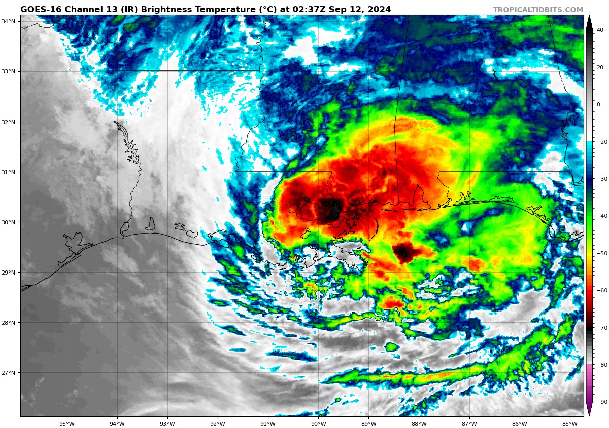
At 10:00 PM CDT, the center of Tropical Storm Francine was located near latitude 30.2 North, longitude 90.6 West. Francine is moving toward the northeast near 16 mph. A slower north-northeastward motion is expected during the next couple of days.
Maximum sustained winds are near 70 mph with higher gusts. Rapid weakening is forecast, and Francine is expected to become a tropical depression by late Thursday and a post-tropical cyclone Thursday night or early Friday.
Tropical-storm-force winds extend outward up to 140 miles from the center. Gusts to hurricane-force have been occurring in the New Orleans area.
The estimated minimum central pressure is 982 MB (29.00 inches).
Hazards Affecting Land
- Wind: Tropical storm conditions are expected to continue in portions of the warning area through early Thursday.
- Rainfall: Francine is expected to bring storm total rainfall of 4 to 8 inches, with local amounts to 12 inches across southeastern Louisiana, Mississippi, far southern Alabama, and the Florida Panhandle through Thursday night. This rainfall could lead to considerable flash, urban, and river flooding.
- Storm Surge: The combination of a dangerous storm surge and the tide will cause normally dry areas near the coast to be flooded by rising waters moving inland from the shoreline. The water could reach the following heights above ground somewhere in the indicated areas if the peak surge occurs at the time of high tide:
- Burns Point, LA to Port Fourchon, LA…5-8 ft
- Port Fourchon, LA to Mouth of the Mississippi River, LA…4-6 ft
- Mouth of the Pearl River, LA to Ocean Springs, MS…4-6 ft
- Lake Pontchartrain…4-6 ft
- Ocean Springs, MS to MS/AL Border…3-5 ft
- Intracoastal City, LA to Burns Point, LA…3-5 ft
- Lake Maurepas…3-5 ft
- Tornadoes: A few tornadoes are possible overnight across parts of southeast Louisiana, southern Mississippi, southern Alabama, and the Florida Panhandle. On Thursday, the tornado risk will move into additional parts of Alabama, southwest Georgia, and the Florida Panhandle.
- Surf: Swells generated by Francine are affecting much of the northern Gulf Coast, likely causing life-threatening surf and rip current conditions. Please consult products from your local weather office.
Category: Alabama's Weather, ALL POSTS, Severe Weather, Tropical
About the Author (Author Profile)
Scott Martin is an operational meteorologist, professional graphic artist, musician, husband, and father. Not only is Scott a member of the National Weather Association, but he is also the Central Alabama Chapter of the NWA president. Scott is also the co-founder of Racecast Weather, which provides forecasts for many racing series across the USA. He also supplies forecasts for the BassMaster Elite Series events including the BassMaster Classic.Subscribe
If you enjoyed this article, subscribe to receive more just like it.


