Midday Nowcast: Increasing Clouds Today; Much Colder Air Later this Week
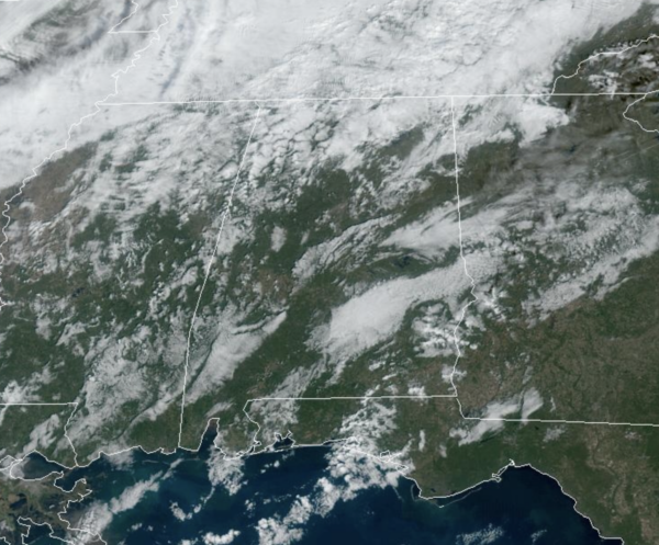
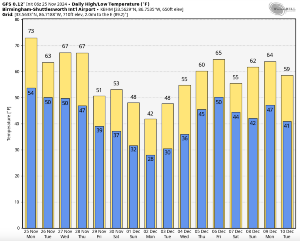
We are seeing increasing clouds today as cold front approaches the state. It is a mild day with many locations climbing into the low to mid 70s this afternoon. The front will bring showers to Alabama tonight and early tomorrow morning…there might be a rumble of thunder but there is no risk of severe storms and rain amounts will be light. The sky will clear tomorrow, becoming sunny by the afternoon. It will be a cooler day with highs closer to 60°.
BIRMINGHAM ALMANAC: For November 25th, the average high for Birmingham is 62° and the average low is 41°. The record high is 78° set in 1921, while the record low is 5° set in 1950. We average 0.14” of precipitation on this date, and the record value is 2.50” set in 1932.
ACROSS THE USA: Coastal/low elevation rain and high elevation snow will extend from the Pacific Northwest into parts of California early this week. Moderate to heavy snow is expected from the Intermountain West into the central Rockies through Tuesday. Several inches of snow is expected over the Upper Peninsula of Michigan into northeast Minnesota through Tuesday.
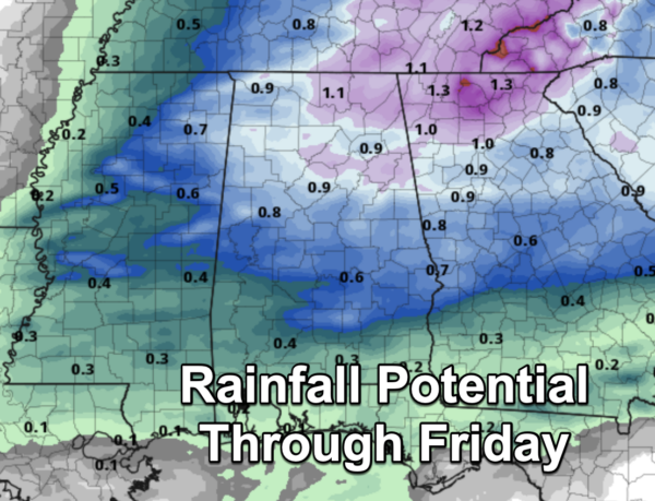
THANKSGIVING: Clouds will increase Wednesday, but the day will be dry with a high in the 60s. Another front will bring rain and a few thunderstorms into Alabama Wednesday night into Thanksgiving Day/Thursday. For now the main window for rain and storms will come from about midnight Wednesday night through noon Thursday. For now, the Storm Prediction Center has no formal severe weather risk area for any part of Alabama, however, at some point a “marginal risk” might be introduced, but with low instability values and unfavorable wind profiles the overall severe thunderstorm risk looks low. However, watch for any potential forecast changes in the coming days.
Rain amounts will be around one inch for the northern half of Alabama, with amounts of around 1/2 inch for the southern counties of the state.Temperatures on Thanksgiving Day will hold in the 50s over North Alabama, with 60s to the south.
BLACK FRIDAY AND THE WEEKEND: Much colder air invades the Deep South to end the week. The weather will be dry with sunny days and fair nights, but temperatures won’t get out of the 40s over the northern half of the state. A freeze is likely pretty much statewide by Saturday morning with many places in the 20s.
COLD START TO DECEMBER: A pattern flip will allow for a cold forecast for at least the first half of the final month of the year. A secondary surge of cold air arrives late in the weekend, and for Monday and Tuesday most places will see highs in the 40s and lows in the 20s. Some colder spots across North Alabama could reach the upper teens early Monday morning. Highs rise a bit, into the 50s over the latter half of the week with lows in the 30s. The air will be dry and there is no risk of any precipitation through the week.
IN THE TROPICS: The Atlantic Basin is quiet, with no tropical development expected and we are likely done with tropical systems this year. Hurricane season ends Sunday, November 30th.
WORLD TEMPERATURE EXTREMES: Over the last 24 hours, the highest observation outside the U.S. was 112.3F at Augrabies Falls, South Africa. The lowest observation was -62.3F at Dome A, Antarctica.
CONTIGUOUS TEMPERATURE EXTREMES: Over the last 24 hours, the highest observation was 91F at Rio Grande Village, TX. The lowest observation was -32F at Peter Sinks, UT.
Category: Alabama's Weather, ALL POSTS, Social Media


