Showers Tonight; Cooler Air Arrives Tomorrow
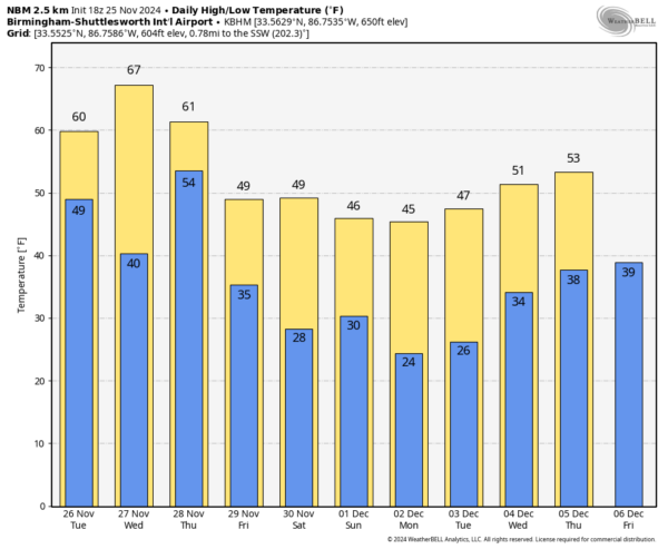
MILD NOVEMBER AFTERNOON: Temperatures are in the 70s across most of Alabama this afternoon with a partly sunny sky. Tonight clouds will thicken ahead of an approaching cold front. The front will bring showers to Alabama tonight and very early tomorrow morning…there might be a rumble of thunder but there is no risk of severe storms. Rain amounts will be light, and the sky becomes sunny during the day tomorrow with a high closer to 60 degrees.
THANKSGIVING: Clouds will increase Wednesday, but the day will be dry with a high in the 60s. Another front will bring rain and a few thunderstorms into Alabama Wednesday night into Thanksgiving Day/Thursday. Models still are not in good agreement concerning timing and wind fields; for now the best idea is that the main window for rain and storms will come from about midnight Wednesday night through noon Thursday. Just understand this could change in future forecasts as we get better clarity.
And there is no formal severe weather risk defined by SPC (NOAA’s Storm Prediction Center). At some point a “marginal risk” might be introduced, but with low instability values and unfavorable wind profiles the overall severe thunderstorm risk looks low. But, again watch for any potential forecast changes. Rain amounts will be around one inch for the northern half of Alabama, with amounts of around 1/2 inch for the southern counties of the state.
Temperatures on Thanksgiving Day will hover in the 50s over North Alabama, with 60s to the south.
FRIDAY AND THE WEEKEND: Much colder air invades the Deep South. The weather will be dry with sunny days and fair nights, but temperatures won’t get out of the 40s over the northern half of the state. A freeze is likely pretty much statewide by Saturday morning with many places in the 20s.
NEXT WEEK: A secondary surge of cold air arrives late in the weekend, and for Monday and Tuesday most places will see highs in the 40s and lows in the 20s. Some colder spots across North Alabama could reach the upper teens early Monday morning. Highs rise a bit, into the 50s over the latter half of the week with lows in the 30s. The air will be dry and there is no risk of any precipitation through Thursday. There is some hint of light rain by the end of the week… see the video briefing for maps, graphics, and more details.
IRON BOWL: The weather will be cold and dry Saturday in Tuscaloosa for this year’s Iron Bowl (Auburn at Alabama, 2:30p CT kickoff). The sky will be sunny, and temperatures will drop from near 48 at kickoff to near 40 by the final whistle.
ON THIS DATE IN 1950: A slow-moving, powerful storm system dumped heavy snow across much of the central Appalachians from November 22 to 30, 1950. Known as “The Great Appalachian Storm of 1950,” the system blanketed areas from western Pennsylvania southward deep into West Virginia with over 30 inches of snow. Several locations received more than 50 inches of snow, and Coburn Creek, West Virginia, reported the greatest snowfall total—a staggering 62 inches.
Frigid cold also stretched from the Northeast into the Ohio Valley and all the way down into the far Southeast. Temperatures fell to 22°F in Pensacola, 5° in Birmingham, 3°F in Atlanta, and 1°F in Asheville, NC. And this record cold led to widespread crop damage, particularly in Georgia and South Carolina. At the time, the Great Appalachian Storm of 1950 was one of the costliest storms on record, and it contributed to at least 160 deaths.
Look for the next video update here by 6:00 a.m. tomorrow…
Category: Alabama's Weather, ALL POSTS, Weather Xtreme Videos


