Midday Nowcast: Cold January Days; Increasing Chance of Winter Weather Troubles Friday
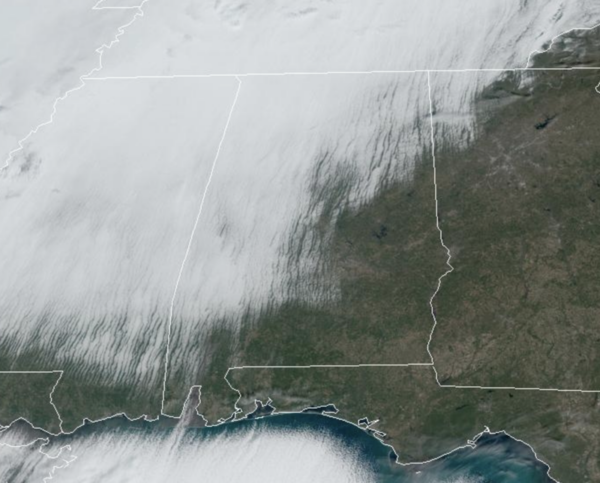
The morning clouds are giving way to afternoon sunshine across Alabama. Today through Thursday, we are experiencing cold days with highs in the upper 30s to lower 40s, despite tons of sunshine in the forecast. These temperatures are 10-15 degrees below average for this time of year. Nights are bone chilling with upper teens and lower 20s.
BIRMINGHAM ALMANAC: For January 7th, the average high for Birmingham is 54° and the average low is 35°. The record high is 74° set in 1989, while the record low is 7° set in 2014. We average 0.16” of precipitation on this date and the record value is 3.34” set in 1998.
WINTER WEATHER TROUBLES: Cold air is in place, and now we have to watch any precipitation moving into the region, and that will occur on Friday as a surface low develops along the Louisiana coast. With all the ingredients coming together, our chance of winter weather precipitation across the northern half of Alabama is increasing.
Here is what we are expecting at this point:
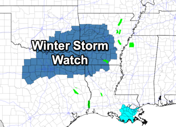
A Winter Storm Watch will likely be issued tomorrow for portions of North and Central Alabama. We are already seeing these issued to our west across North Texas, Oklahoma, Louisiana, and Arkansas today.
A mix of snow, freezing rain, and sleet will begin during the pre-dawn hours Friday across Alabama, while temperatures are below freezing. Impacts on travel are expected Friday morning across the northern half of the state. Temperatures should slowly warm into the mid 30s during the day Friday, so the it should become a rain and sleet event by the midday hours, and though surface temperatures should be above freezing, travel will not be advised. For North Alabama, snow or freezing rain could continue much of the day over the Tennessee Valley.
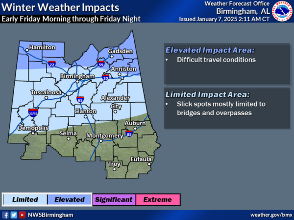
Snow potential for the Tennessee Valley for now is 2-4 inches with lighter amounts to the south (1/2 to 2 inches for places like Tuscaloosa, Birmingham, Anniston). Understand the forecast snow totals will change and could be raised higher as new model data comes in and we get better clarity. The ground and infrastructure will be cold and with lots of moisture moving into the state, these factors are favorable for a winter storm event over North Alabama. Also, placement of winter weather impacts will change as well. Some model data suggest some freezing rain is possible as far south as Selma, Montgomery and Phenix City.
The precipitation ends Friday evening, but we could see snow flurries or snow showers on Saturday on the back side of the departing storm system. We also note, temperatures will fall back below freezing Friday night, so icy travel is likely Friday night and into early Saturday.
As with any winter weather precipitation forecast in the Deep South, this forecast will change in the coming days, so make sure you are getting the most up-to-date forecast. As we get closer to the event, we will have a better understanding of how the event should play out. But my advice for preparation right now is to once you get in Thursday evening, plan to stay hunkered down through Friday, Friday night, and into Saturday as road and travel conditions will not be ideal.
Saturday and Sunday will remain cold with highs in the 40s and lows in the 20s. The cold weather will continue into next week as the pattern will continue allow for below-average temperatures. And again with cold air remaining in place, we may have to deal with more winter weather mischief in the coming weeks.
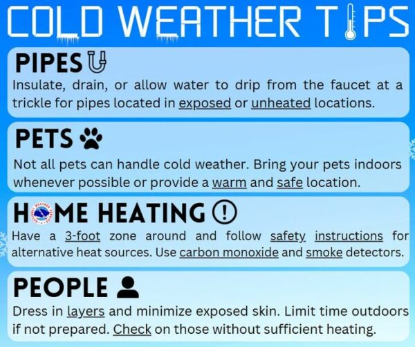
COLD WEATHER SAFETY: Everyone should review their cold weather safety involving pipes, pets, home heating, and people. For pipes, insulate, drain, or allow water to drip from the faucet at a trickle for pipes located in exposed or unheated locations. Not all pets can handle cold weather. Bring your pets indoors whenever possible or provide a warm and safe location. For alternative heating sources like space heaters and wood stoves, have a 3-foot zone around and follow safety instructions. Utilize carbon monoxide and smoke detectors. For people, dress in layers and minimize exposed skin. Limit time outdoors if not prepared. Check on those without sufficient heating.
WORLD TEMPERATURE EXTREMES: Over the last 24 hours, the highest observation outside the U.S. was 111.0F at Urandangi Aerodrome, Australia. The lowest observation was -51.7F at Kjusjur, Russia.
CONTIGUOUS TEMPERATURE EXTREMES: Over the last 24 hours, the highest observation was 83F at Hollywood and Atlantis, FL. The lowest observation was -16F at Forest Center, MN.
Category: Alabama's Weather, ALL POSTS, Social Media
About the Author (Author Profile)
Macon, Georgia Television Chief Meteorologist, Birmingham native, and long time Contributor on AlabamaWX. Stormchaser. I did not choose Weather, it chose Me. College Football Fanatic. @Ryan_StinnetSubscribe
If you enjoyed this article, subscribe to receive more just like it.


