Wet & Mild Today, Cold Spell Starts Sunday; Potential Winter Storm on Tuesday
For today, we’ll have a warm font that will push northeastward through Alabama, bringing warm temperatures and a good bit of moisture for showers and maybe even a few rumbles of thunder. However, those temperatures will begin to drastically drop as a strong cold front moves in during the evening hours, blasting the state with a very cold and dry airmass. While afternoon highs will top out in the upper 50s to the lower 70s from north to south, overnight lows will be in the upper 20s to the mid 40s from northwest to southeast. Don’t be surprised if we see some wrap-around snow flurries during the night and overnight hours.
Sunday will be much colder with diminishing clouds throughout the day. The dreaded 540 line will be all the way in South Alabama, meaning that we will see highs only in the lower 30s to the mid 50s. Lows in the lower teens to the lower 20s. The news is that once much of the northern half of the state drops below the freezing point on Sunday, highs may not reach above freezing again until Wednesday.
On Monday, after the bitterly cold start, there will be plenty of sunshine through the morning and into the early afternoon, before clouds start to move in from the west from the upcoming winter storm threat. There is no threat of any wintry precipitation for now, as that will begin to move in on Tuesday morning. Highs only in the mid 20s to the lower 40s from northeast to southwest.
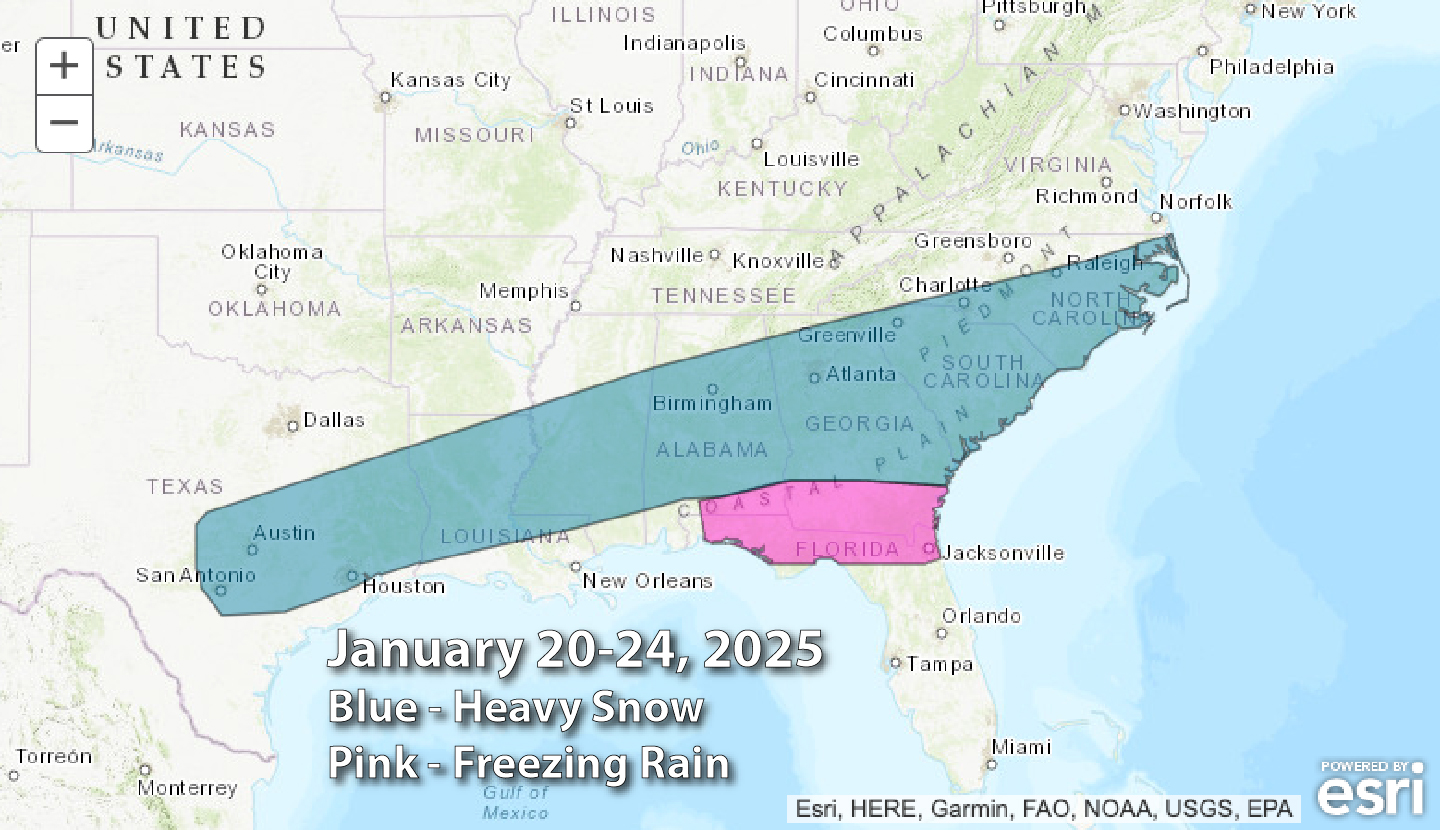
Ok, so here we get into the winter storm threat that will most likely affect much of Alabama on Tuesday. The Climate Prediction Center has outlined a good portion of the southeast, including much of Central and South Alabama with the potential of receiving heavy snow, while the southern and southeastern portions of the state with the potential of freezing rain. This in an increase in coverage area since previous updates.
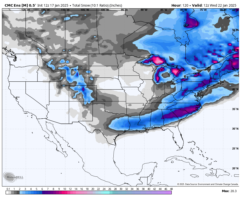
Canadian Model Ensembles total snow run valid 6am Wednesday.
At the time of production of this post late Friday night, the latest model ensemble runs have come in, and the European and the GFS models are in very close agreement that the heavier precipitation will be over the southern half of the state south of the I-20 corridor. However, the Canadian models have nearly the entire state receiving somewhere between 3–7 inches of snowfall. While I believe that is an outlier, we still can’t throw it out in the garbage.
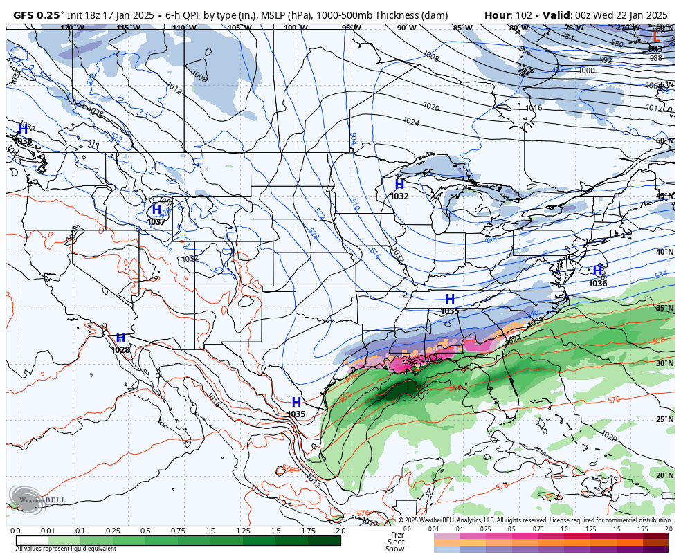
GFS valid at 6pm Tuesday evening.
Looking at the model runs, light snow will begin to move into the state as early as sunrise on Tuesday morning over the southwestern and western parts. By noon, much of Central Alabama will be seeing some light snowfall, as heavier snow and sleet start to move in over the southwestern portions. By 6PM, the southern half of the state is getting heavy snowfall and a mix of sleet and freezing rain, while a good chunk of the northern half is still getting light snow. And as we reach midnight, much of the activity has moves out of the northern half, while a wintry mix continues over the southern half. We’ll get a better idea of what and how much to expect once the higher-resolution models come into play. Highs are expected to reach the 30s statewide, but we may see those temperatures even struggle to make that if snowfall starts earlier.
After waking up with early morning lows in the lower teens to the lower 20s, it looks like that daytime highs will all finally get above freezing on Wednesday. High pressure will be off to our southwest over southern Mississippi, bringing in much drier air and some sunshine, hopefully to help melt away any snow and ice from the roadways and bridges. Afternoon highs back into the mid 30s to the lower 40s.
Thursday is looking to be a partly to mostly cloudy day across the state, and just a bit warmer. After the chilly start, afternoon highs will max out in the lower 40s to the lower 50s.
A deepening trough pushes the 540 line down over the northern Gulf of Mexico on Friday, and we could see a few snow flurries over the extreme northern portions of the state during the afternoon and evening, while a few sprinkles will be possible south of that. For now, we do not believe this will be an issue. Afternoon highs look to top out in the lower 40s to the lower 50s.
Category: Alabama's Weather, ALL POSTS, Social Media, Weather Xtreme Videos, Winter Weather
About the Author (Author Profile)
Scott Martin is an operational meteorologist, professional graphic artist, musician, husband, and father. Not only is Scott a member of the National Weather Association, but he is also the Central Alabama Chapter of the NWA president. Scott is also the co-founder of Racecast Weather, which provides forecasts for many racing series across the USA. He also supplies forecasts for the BassMaster Elite Series events including the BassMaster Classic.Subscribe
If you enjoyed this article, subscribe to receive more just like it.


