Midday Nowcast: Sunny Tuesday, Some Storms Thursday, Increasing Severe Weather Threat This Weekend
SPLENDID SPRING WEATHER: Today and tomorrow the weather is gorgeous across Alabama with sunshine in full supply and comfortable afternoon temperatures. Expect highs in the low and mid 70s both days, while night will be chilly with lows in the 40s.
AIR QUALITY ALERT: A “code red” air quality alert is in effect for the Birmingham metro (Jefferson and Shelby counties) today due to particulate pollution; smoke from a large prescribed burn (780 acres) over the Bankhead National Forest near the Winston/Lawrence county line was transported into the region late yesterday. Thankfully, the upper winds are shifting and the smoke will be moving move out of the Birmingham metro today.
BIRMINGHAM ALMANAC: For March 11th, the average high for Birmingham is 66° and the average low is 44°. The record high is 85° set in 1911, while the record low is 21° set in 1998. We average 0.19” of precipitation on this date and the record value is 2.75” set in 1968.
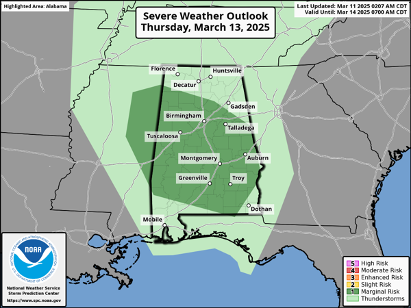
SOME STORMS THURSDAY: On Thursday, a quick moving system will bring rain back to Alabama. A few thunderstorms are possible, and the SPC has introduced a “marginal risk” (level 1 of 5) for severe storms Thursday across much of Alabama. A few storms could produce gusty winds and hail, but the overall threat is low due to lack of dynamic support. Rain amounts Thursday should be generally under 1/2 inch.
TOTAL LUNAR ECLIPSE THURSDAY NIGHT: The Moon will pass into Earth’s shadow and appear to turn red on late Thursday night and into the early morning hours of Friday.
In a total lunar eclipse, the entire Moon falls within the darkest part of Earth’s shadow, called the umbra. When the Moon is within the umbra, it appears red-orange. Lunar eclipses are sometimes called “Blood Moons” because of this phenomenon. You don’t need any special equipment to observe a lunar eclipse, although binoculars or a telescope will enhance the view. A dark environment away from bright lights makes for the best viewing conditions.
At Birmingham (and for most of Alabama), totality will begin at 1:26 AM CDT Friday March 14, ending at 2:31AM CDT. We are expecting clouds and showers Thursday, but hopefully clouds will move out by the time of the eclipse.
FANTASTIC FRIDAY: The Thursday system will be out of here and the weather looks incredible Friday…the day will feature a mix of and sun and clouds, with warm temperatures; highs will range from the upper 70s to lower 80s.
INCREASING SEVERE STORM THREAT SATURDAY: A very dynamic storm system will bring the threat of severe thunderstorms to the Deep South this weekend. On Friday, severe storms are expected to our west throughout the Mississippi Valley up into the Midwest, and this first round of storms could enter Northwest Alabama Friday night. As the entire system moves east, the severe weather threat will shift east into Alabama on Saturday and Saturday night. We are likely to have multiple rounds of severe storms Friday night through Sunday morning, a lot of discuss, so let’s dive right in…
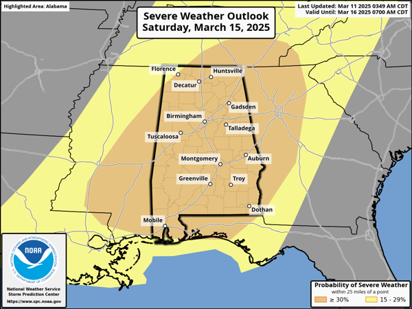
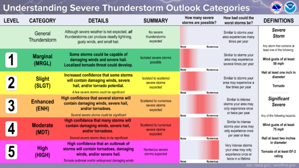
The Storm Prediction Center (SPC) has expanded the “enhanced risk” (level 3 of 5) of severe storms to cover almost all of Alabama Saturday. This threat level will likely continue to change in the coming days, the threat level could be increased and expanded more. I would not be surprised to see this risk get increased to a “moderate risk” (level 4 of 5) as we get closer to the weekend. Here is a reminder of what each risk category means and its the potential threats.
Click image to enlarge.
Confidence is high the synoptic scale pattern (large scale) will be very supportive of severe weather. Model data is suggesting the mesoscale features (small scale) will be supportive for severe weather as well. Over the next few days, we will continue to get a better idea and have a better understanding of the magnitude and impacts of the event. We will also get a better timing of the event in the coming days.
GRADIENT WINDS: Ahead of the storm system, Friday night and Saturday strong southerly winds will be howling north into the system. Much like the last system, these winds are likely to cause power issues.
THREATS: All modes/types of severe weather will be possible with each round of severe storms, with the greatest threat of severe storms coming Saturday and Saturday night. Large hail, damaging winds, and tornadoes are expected; a few strong strong tornadoes will be possible (EF-2 or higher by definition).
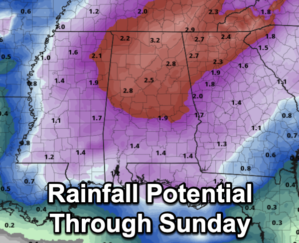
RAINFALL: Rain amounts of 2-3 inches are possible, and some flooding issues could develop.
CALL TO ACTION: With any severe weather event, be ready to act immediately…Have multiple, reliable ways to receive severe weather alerts, NEVER, ever, ever rely on a outdoor siren. Every Alabama home and business needs a NOAA Weather Radio (the most popular model is the Midland WR-120, which is sold in most local big box retailers). The other way is your phone…be sure emergency alerts are enabled (look under settings, and notifications), and install the free ABC 33/40 Weather app.
Know the safe place in your house, and in that safe place have helmets for everyone. Bicycle helmets and batting helmets work well. We also recommend portable air horns and hard soled shoes for everyone. If you live in an apartment complex, you can’t be above the first level. Shelter with a friend on the ground level, or ask management if they can open the clubhouse during a tornado warning.
If you live in a mobile home, you cannot stay there during a tornado warning, they offer little to know protection from severe storms. Know the location of the nearest shelter, or business that is open 24/7. Know how to get there quickly.
BE A HERO: You can help us. Tell your friends, neighbors, and relatives about the threat, and what they need to do to get ready. And, if they fall in a tornado warning polygon, call them or text them to let them know about the threat. You are our most valuable resource in spreading the word!
Again, this is the core of our severe weather season in Alabama, so events like this are not uncommon. Many of you have anxiety about severe weather, especially those that have gone through tornadoes or other kinds of violent weather. Have comfort knowing that even on the biggest severe weather days, odds of any one home being hit by a tornado are very low. But, you have to pay attention and be prepared. We will get through the event together.
AFTER THE STORMS: Dry air returns Sunday; highs over the weekend will be in the 70s. The first half of the following week looks dry and mild; rain and storms are likely to return by Thursday or Friday. Typically, this time of year, you will get into a 5-7 day storm cycle, meaning for the next several weeks, you can expect the threat of rain and storms at least once a week.
WORLD TEMPERATURE EXTREMES: Over the last 24 hours, the highest observation outside the U.S. was 111.2F at Birni-N’Konni, Niger. The lowest observation was -80.1F at Vostok, Antarctica.
CONTIGUOUS TEMPERATURE EXTREMES: Over the last 24 hours, the highest observation was 91F at Hollywood, Fort Lauderdale, and Miami-Opa Locka, FL. The lowest observation was -12F at Peter Sinks, UT.
Category: Alabama's Weather, ALL POSTS, Severe Weather, Social Media
About the Author (Author Profile)
Macon, Georgia Television Chief Meteorologist, Birmingham native, and long time Contributor on AlabamaWX. Stormchaser. I did not choose Weather, it chose Me. College Football Fanatic. @Ryan_StinnetSubscribe
If you enjoyed this article, subscribe to receive more just like it.


