Midday Nowcast: Sunny Today; Freeze Warning and Frost Advisory Tonight
SPLENDID SPRING WEATHER: Sunshine, blue sky, and refreshing temperatures are the forecast today and the next few days across Alabama. Highs this afternoon are in the 60s, tomorrow will feature highs in the upper 60s, while low 70s return Thursday. Nights will be cold, with 20s and 30s tonight, followed by upper 30s and lower 40s the rest of this week.
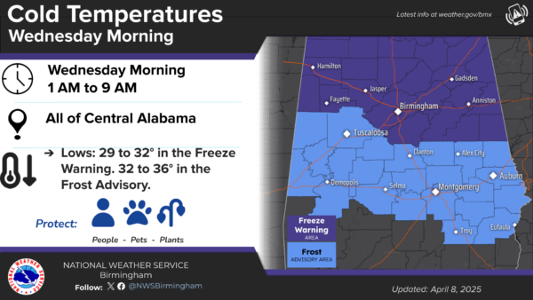
FREEZE WARNING/FROST ADVISORY: Protect sensitive vegetation tonight as temperatures slide into the upper 20s and lower 30s across North and Central Alabama tonight. A freeze warning is in effect for areas from the Birmingham Metro north and east. A frost advisory is in effect for the rest of Central Alabama and extends as far south as Troy and Eufaula. Frost will be widespread in these ares tomorrow morning.
BIRMINGHAM ALMANAC: For April 8th, the average high for Birmingham is 73° and the average low is 50°. The record high is 87° set in 1967, while the record low is 29° set in 1990. We average 0.18” of precipitation on this date and the record value is 2.86” set in 2023.
OUR NEXT WEATHER MAKER: A cold front will bring some scattered showers and thunderstorms to the state late Thursday and Thursday night. The Storm Prediction Center has defined a very low end “marginal risk” (level 1 of 5) of severe thunderstorms for areas along and north of Intestate 20.
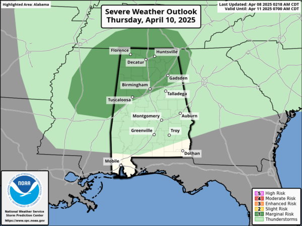
Moisture levels will be limited, add in weak wind fields and low instability, and we just aren’t very concerned about any severe weather threat at this point. Rain amounts will be less than one-half inch in areas where storms develop, but again, these will be rather scattered in nature and we expect many spots to remain dry.
FRIDAY AND THE WEEKEND: Cooler air moves into the state Friday behind the front. The day will feature a gradually clearing sky with highs in the 60s. The weekend will be cool and dry across the Deep South. Lows will be mostly in the 40s, with highs in the 60s Saturday and 70s Sunday.
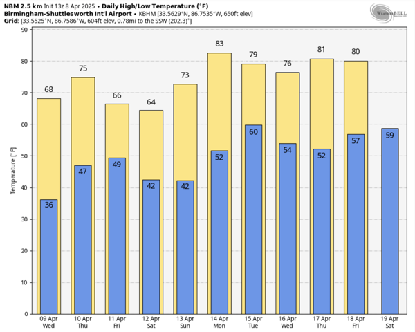
INTO NEXT WEEK: The calm weather pattern continues; much of the week will be dry. We will mention some risk of showers Tuesday with a cold front, but we see no risk of any heavy rain or severe storms. As another upper ridge builds in, we are likely to see highs return to the 80s.
WORLD TEMPERATURE EXTREMES: Over the last 24 hours, the highest observation outside the U.S. was 115.5F at Barmer, India. The lowest observation was -98.7F at Vostok, Antarctica.
CONTIGUOUS TEMPERATURE EXTREMES: Over the last 24 hours, the highest observation was 95F at Ogilby, CA. The lowest observation was -6F at Grand Marais, MN.
Category: Alabama's Weather, ALL POSTS, Social Media
About the Author (Author Profile)
Macon, Georgia Television Chief Meteorologist, Birmingham native, and long time Contributor on AlabamaWX. Stormchaser. I did not choose Weather, it chose Me. College Football Fanatic. @Ryan_StinnetSubscribe
If you enjoyed this article, subscribe to receive more just like it.


