Midday Nowcast: Sunshine and Blue Sky Today; Highs in the 80s through Easter Weekend
OH SO NICE: After a chilly morning across Alabama, we are warming up nicely this afternoon with highs in the 70s. High pressure is centered over the Lower Mississippi Valley today and will keep our winds blowing out of the northwest today and sets the stage for another chilly night with upper 40s and lower 50s. The high slides east in the coming day and switches our flow out of the south, bringing a warming trend through the weekend. Expect generally sunny, dry days with highs returning to the 80s tomorrow, with mid 80s likely Friday and Saturday.
BIRMINGHAM ALMANAC: For April 16th, the average high for Birmingham is 75° and the average low is 52°. The record high is 89° set in 1977, while the record low is 32° set in 2014. We average 0.17” of precipitation on this date and the record value is 4.18” set in 1900.
EASTER SUNDAY: For those sunrise services Sunday morning, expect temperatures generally in the low to mid 60s. Then during the day, our winds will increase out of the south, and we will see a mix of sun and clouds with highs in the 80s. It looks like rain will return to the state late Sunday night as a cold front approaches.
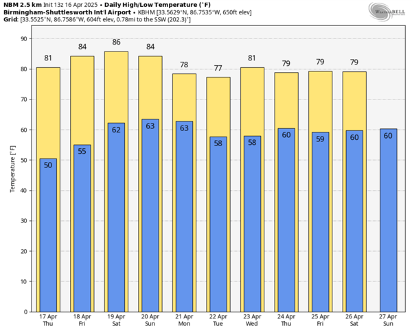
NEXT WEEK: The front looks to stall across the northern portions of the state early next week. The air will be warm and unstable, allowing for showers and thunderstorms Monday and Tuesday. For now the severe weather threat remains low with the main dynamics being well north of Alabama. Highs next week will remain in the 80s.
WORLD TEMPERATURE EXTREMES: Over the last 24 hours, the highest observation outside the U.S. was 116.6F at Nawabshah, Pakistan. The lowest observation was -99.4F at Concordia, Antarctica.
CONTIGUOUS TEMPERATURE EXTREMES: Over the last 24 hours, the highest observation was 99F at Death Valley, CA. The lowest observation was 9F at Peter Sinks, UT.
Category: Alabama's Weather, ALL POSTS, Social Media
About the Author (Author Profile)
Macon, Georgia Television Chief Meteorologist, Birmingham native, and long time Contributor on AlabamaWX. Stormchaser. I did not choose Weather, it chose Me. College Football Fanatic. @Ryan_StinnetSubscribe
If you enjoyed this article, subscribe to receive more just like it.


