Midday Nowcast: Muggy Spring Days with Scattered Showers and Storms
Click image to enlarge.
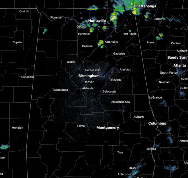
AIR YOU CAN WEAR: It remains warm and muggy across Alabama today and we continue to see more clouds than sunshine. Highs today are ranging from the upper 70s to low and mid 80s. As in recent days, the radar is active again across Alabama with scattered showers and storms. All storms will be producing frequent lightning and very heavy rainfall, which could lead to some localized flash flooding. An isolated severe storm is not out of the question as a storm or two could produce gusty winds and/or marginally severe hail. At the writing of this forecast, there wasn’t a lot of activity on the radar, but that will change through the afternoon and evening hours.
BIRMINGHAM ALMANAC: For April 24th, the average high for Birmingham is 77° and the average low is 55°. The record high is 90° set in 1925, while the record low is 35° set in 1986. We average 0.16” of precipitation on this date and the record value is 3.08” set in 2010.
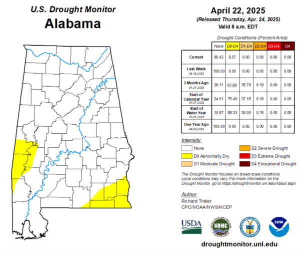
DROUGHT MONITOR: It is Thursday, meaning the latest drought monitor has been released. Some changes in Alabama and the state is no longer drought free. Abnormally Dry conditions have return to 9.57% of the state. This includes areas of Southwest Alabama including portions of Sumter, Choctaw, Washington, Clarke, Marengo, and Greene Counties. In Southeast Alabama, the Wiregrass Region, portions of Covington, Geneva, Coffee, Dale, Henry, and Houston counties are experiencing the conditions as well.
Click image to enlarge.
THROUGH THE WEEKEND: Showers and storms will be common tomorrow, but will become fewer in number and more isolated in nature for the weekend, as the upper level temperatures warm, meaning lower instability. The chance of any spot seeing rain will be in the 30-40% range, and most of the storms will occur during the afternoon and evening hours, however, rain will be possible at anytime. Despite the lower rain chances, the air mass will not change, as the days will feature a mix of sun and clouds, with highs in the 80s and lows in the 60s.
RACE WEEKEND: The weather will be warm and muggy, and though some showers and storms will remain a threat, most of the weekend should be dry at Talladega through Sunday. The chance of an afternoon shower/storm is a bit higher, 30-40% range; highs will remain in the 80s.
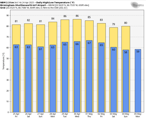
NEXT WEEK: Little change in the forecast with isolated showers and storms remaining a possibility for the first half of the week; highs will remain in the 80s. A front is expected over the second half of the week, and higher rain chances are expected by Thursday and Friday. Too early to tell if severe storms will be a threat, but tis the season. The front look to bring a late season cool snap for the first weekend of May as highs slip back down into the 70s with lows in the 50s.
WORLD TEMPERATURE EXTREMES: Over the last 24 hours, the highest observation outside the U.S. was 114.8F at Sibi, Pakistan. The lowest observation was -96.0F at Vostok, Antarctica.
CONTIGUOUS TEMPERATURE EXTREMES: Over the last 24 hours, the highest observation was 97F at Death Valley, CA. The lowest observation was 9F at Verdi, CA.
Category: Alabama's Weather, ALL POSTS, Social Media
About the Author (Author Profile)
Macon, Georgia Television Chief Meteorologist, Birmingham native, and long time Contributor on AlabamaWX. Stormchaser. I did not choose Weather, it chose Me. College Football Fanatic. @Ryan_StinnetSubscribe
If you enjoyed this article, subscribe to receive more just like it.


