Midday Nowcast: Quiet End to April, Storms Return Tomorrow; Plus a Birdcast
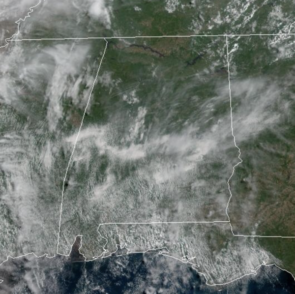
SO LONG APRIL: We are in the final hours of April, and the weather is very warm and pretty calm across Alabama. We are seeing a mix of sun and clouds, with only isolated afternoon/evening showers and storms. Temperatures are above average for this time of year, as mid to upper 80s are widespread this afternoon.
BIRMINGHAM ALMANAC: For April 30th, the average high for Birmingham is 78° and the average low is 56°. The record high is 91° set in 1943, while the record low is 36° set in 1969. We average 0.16” of precipitation on this date and the record value is 2.13” set in 1929.

BIRDCAST: You read that right, have you ever heard of it? The Birdcast is a bird migration forecasts. The Cornell Lab of Ornithology has unveiled real-time analysis maps that illustrate the intensity of nocturnal bird migration across the United States. It is updated every six hours, predicts nocturnal migration occurring three hours after local sunset. These forecasts are based on models trained on 23 years of bird movement data detected by the U.S. NEXRAD weather surveillance radar network. The models utilize the Global Forecasting System (GFS) to predict suitable conditions for migration.
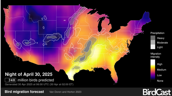
Areas depicted in lighter/brighter colors experienced more intense bird migration. The maps also display migration traffic rates (MTR), which measure the number of birds per hour crossing a one-kilometer line perpendicular to their flight path, expressed in birds per kilometer per hour. Tonight, some 348 million birds are expected to be migrating northward through the U.S. with the highest numbers across South Texas and in the Mid-Mississippi Valley.
USA BRIEF: Heavy to excessive rainfall may produce additional flash flooding today across parts of the southern Plains where the greatest risk is along the Red River Valley into western Arkansas. Scattered severe thunderstorms are possible today from north central Texas into the ArkLaTex Region. Large to very large hail, damaging winds, and tornadoes are all possible, with some strong-tornado potential.
STORMS TO START MAY: A cold front will move towards Alabama tomorrow and the chance of showers and thunderstorms will increase. Most of tomorrow will be dry, but showers and storms should become widespread late tomorrow afternoon, tomorrow night, and into Friday. The Storm Prediction Center continues a “marginal risk” of severe thunderstorms for much of Alabama tomorrow evening and night.
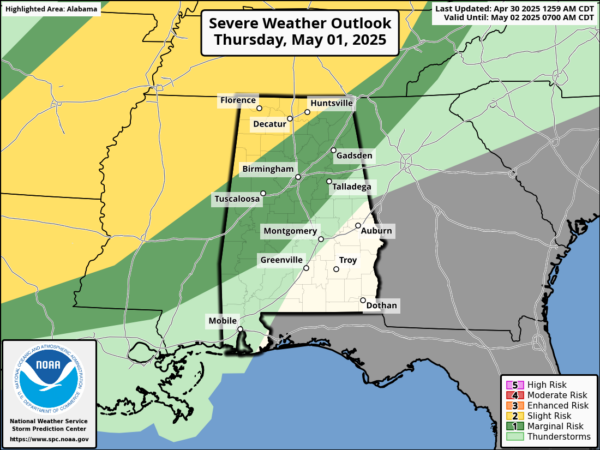
They have increased the severe weather threat to a “slight risk” (level 2 of 5) for Northwest Alabama, north and west of a line from Sulligent to Double Springs to Huntsville. Wind fields will be relatively week, and instability values will not be overly impressive for early May, so the this is not a major threat, but some storms will be strong to locally severe and could produce marginal severe hail and gusty winds.
FRIDAY AND THE WEEKEND: The cold front will slowly drift south through the state, and we will have to mention showers and storms in the forecast Friday and into Saturday. It won’t rain everywhere or all the time, but expect occasional rain and storms at times. The severe weather threat is very low, but a few stronger storms could produce gusty winds and small hail. Rain amounts will be in the 1/2 to 1 inch range for most of the state. Highs Friday and Saturday will be in the upper 70s and lower 80s.
Cooler, drier air will roll into the state late Saturday night, setting up a beautiful Sunday. Temperatures drop into the 50s over much of Alabama early Sunday morning and highs will be in the 70s with lower humidity. By Monday morning, widespread 40s are likely for much of North and Central Alabama.
NEXT WEEK: Much of the week look fairly dry with highs will be in the 80s, lows will be in the 50s and 60s.
WORLD TEMPERATURE EXTREMES: Over the last 24 hours, the highest observation outside the U.S. was 117.3F at Nawabshah, Pakistan. The lowest observation was -83.7F at Dome A, Antarctica.
CONTIGUOUS TEMPERATURE EXTREMES: Over the last 24 hours, the highest observation was 107F at Rio Grande Village, TX. The lowest observation was 14F at Covington, MI.
Category: Alabama's Weather, ALL POSTS, Social Media
About the Author (Author Profile)
Macon, Georgia Television Chief Meteorologist, Birmingham native, and long time Contributor on AlabamaWX. Stormchaser. I did not choose Weather, it chose Me. College Football Fanatic. @Ryan_StinnetSubscribe
If you enjoyed this article, subscribe to receive more just like it.


