Severe Storm Targeting Western Franklin and Colbert Counties, Strong Storm Over Marion, Another Moving into Colbert/Franklin
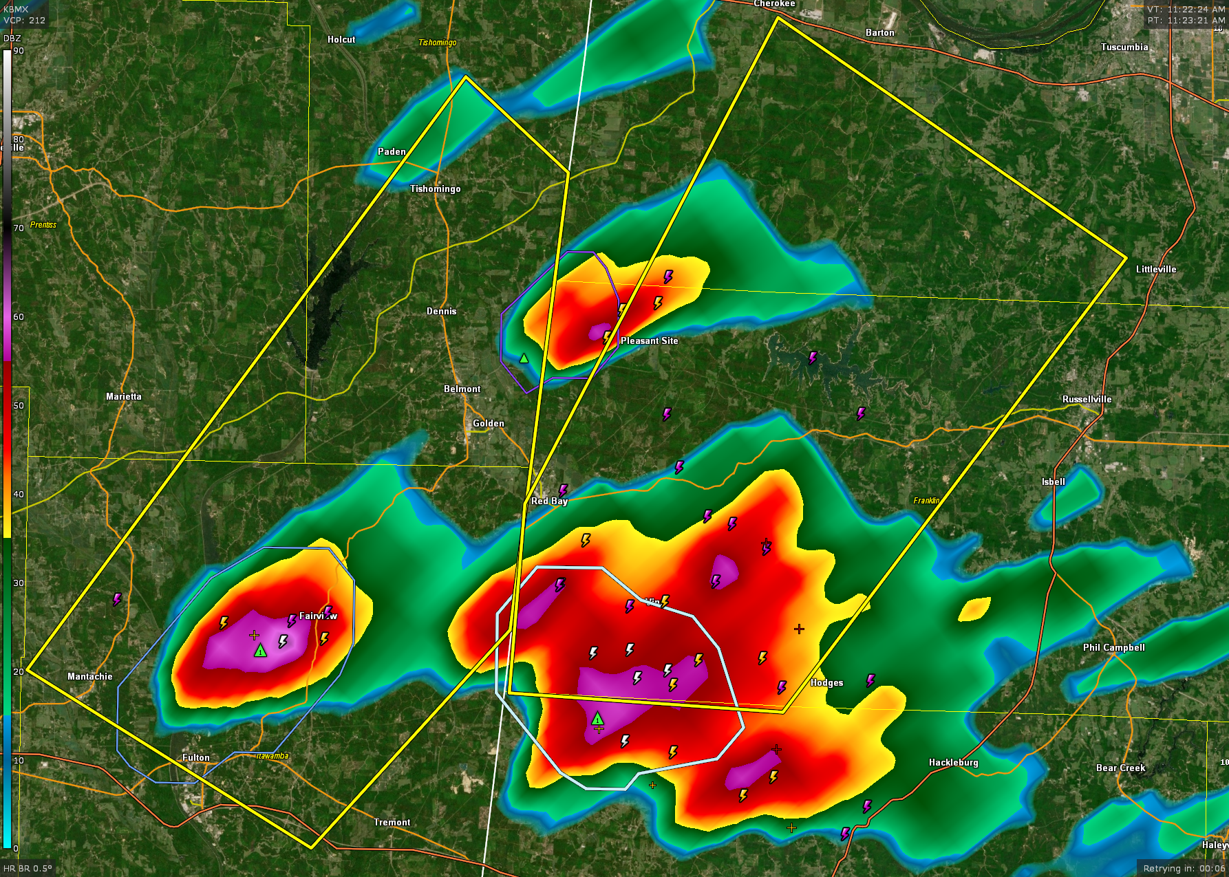
A severe thunderstorm warning is in effect until 12:15 PM for southwestern Colbert and western Franklin counties in northwest Alabama. At 11:15 AM, the storm was located 7 miles south of Red Bay and moving northeast at 30 mph.
Radar indicates the potential for quarter-size hail and wind gusts up to 60 mph. The storm may cause damage to roofs, trees, siding, and vehicles. Dangerous cloud-to-ground lightning is also occurring.
Locations in the path include Red Bay, Vina, Belgreen, Cedar Creek Reservoir, Atwood, and Pleasant Site. Residents should move to an interior room on the lowest floor of a sturdy building and stay there until the storm passes.
A strong thunderstorm near Weston, just west of Hamilton, is moving northeast at 20 mph and will affect northwestern Marion County through 12:15 PM. The storm is producing wind gusts up to 40 mph and penny-size hail, with potential to knock down tree limbs and cause minor hail damage to vegetation. Torrential rain and frequent lightning accompany the storm, with impacts expected in communities like Pigeye, Shottsville, Bexar, and around Rankin Fite Airport.
A severe thunderstorm continues to move northeast at 20 mph across northern Itawamba, southern Tishomingo, and southeastern Prentiss counties in northeast Mississippi, with radar indicating quarter-size hail and wind gusts up to 60 mph. The storm, near Fulton at 11:15 AM, is capable of damaging trees, roofs, and vehicles, with locations like Belmont, Mantachie, Golden, and Tishomingo State Park in its path.
This storm will impact western Colbert and northwestern Franklin counties through 12:15 PM. The NWS in Huntsville chose to issue a significant weather advisory, stopping short of a severe thunderstorm warning on it for now. The storm is producing wind gusts up to 50 mph and nickel-size hail, which may result in minor damage to vegetation and unsecured objects. Communities in the path include Cherokee, Malone, New Bethel, Barton, and Posey Loop. A Severe Thunderstorm Watch remains in effect for the area until 5:00 PM.
Category: Alabama's Weather, ALL POSTS, Severe Weather, Social Media
About the Author (Author Profile)
Bill Murray is the President of The Weather Factory. He is the site's official weather historian and a weekend forecaster. He also anchors the site's severe weather coverage. Bill Murray is the proud holder of National Weather Association Digital Seal #0001 @wxhistorianSubscribe
If you enjoyed this article, subscribe to receive more just like it.


