Mesoscale Discussion: Damaging Winds Possible as Squall Line Moves East Across Alabama
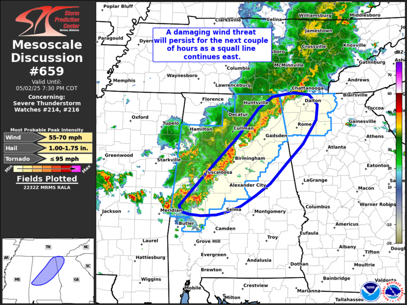
A line of strong to severe storms continues to push east across central and northern Alabama into far northwest Georgia this evening. This squall line is packing a punch with damaging wind gusts the primary threat as it moves through the area.
Radar shows a fairly solid line from northeast to central Alabama. Some parts of the line are a bit disorganized due to weaker wind shear in the low and mid-levels of the atmosphere, but other sections are showing strong winds just above the surface—anywhere from 35 to 50 mph, based on radar velocity and surface observations. The environment ahead of this line is still primed for severe weather, with steep lapse rates and moderate instability supporting strong winds reaching the ground.
As long as sections of the line can maintain their structure, we’ll continue to see the threat for damaging winds. However, after sunset, we may see the storms start to weaken a bit as the atmosphere becomes less supportive of severe development.
If you’re ahead of this line in eastern Alabama or west Georgia, stay weather aware and be ready to take shelter if warnings are issued.
Category: Alabama's Weather, ALL POSTS, Severe Weather, Social Media
About the Author (Author Profile)
Scott Martin is an operational meteorologist, professional graphic artist, musician, husband, and father. Not only is Scott a member of the National Weather Association, but he is also the Central Alabama Chapter of the NWA president. Scott is also the co-founder of Racecast Weather, which provides forecasts for many racing series across the USA. He also supplies forecasts for the BassMaster Elite Series events including the BassMaster Classic.Subscribe
If you enjoyed this article, subscribe to receive more just like it.


